Loading...

🎆 50% off 4th of July sale on Supporter Accounts — now through July 6! Learn More.

Fall Run Hidden Waterfalls

Directions
Map
Pictures
Send to App
Distance:
0.4 Miles / 0.6 km
Type:
Out-and-Back
Difficulty:
Hard
Time to Hike:
~12 minutes
Features:
Surface Type:
Dirt
Park:
Fall Run Park
Town:
Glenshaw, Pennsylvania
Directions:
40.530309, -79.948118
Added:
February 25, 2018
Updated:
March 20, 2019
Copy Trail Link Hiking this trail? Send a friend or family member a link to this trail guide for your own safety. Hike at your own risk (disclaimer)
Loading...
Loading...
136'

Total Change
132'

Ascent
132'

Descent

Download the Trail Route for Offline Use

Supporters get exclusive access to download trail routes to the MyHikes app for offline use. Stay prepared on your adventure, even without an internet connection! Become a Supporter today to unlock this feature and hike with confidence.

Send to App

Fall Run Hidden Waterfalls

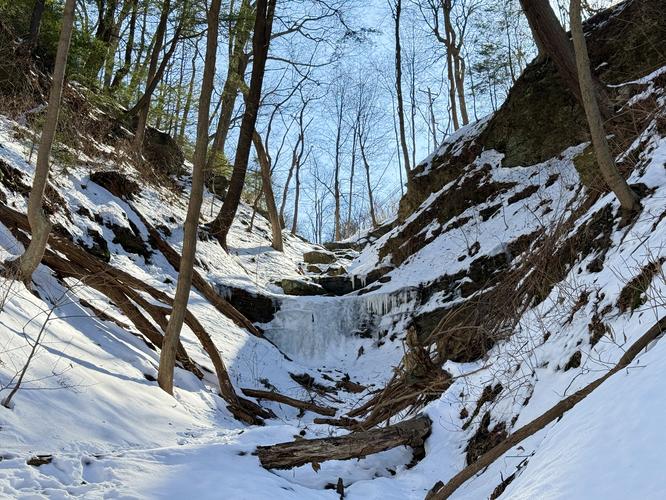
The Hidden Waterfalls Trail at Fall Run Park in Glenshaw, Pennsylvania is a difficult 0.4 mile out-and-back trail that leads up a steep hillside to a lookout point with two tall and tucked-away waterfalls with heights of over 50 feet.

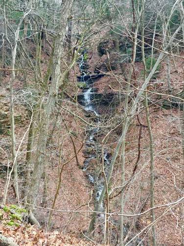
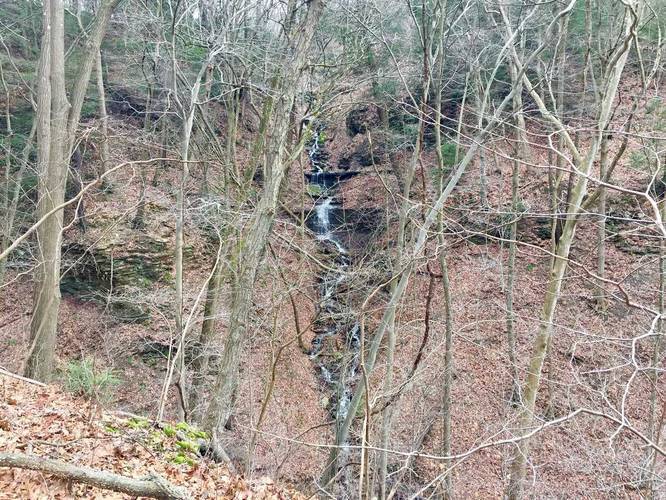
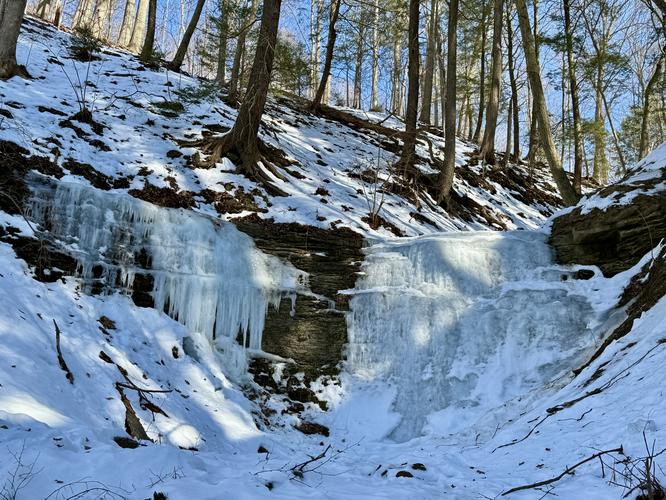
The two waterfalls are multi-tiered and cascade down the hillside before merging together in the creek below. The creek then runs west to feed into Fall Run Creek - to where yet another waterfall can be found (viewed from the Fall Run Trail).

The trail is very narrow and climbs a steep rocky slope, which is why the trail is labeled as hard or difficult. Once the trail levels out, you'll notice there's a small spur trail leading downhill to a platform overlooking the waterfall to the south - this is the best view of either of the falls that you'll get. Both waterfalls run heavier in the winter and Spring, so it's possible that these falls are dried up by the Summer.

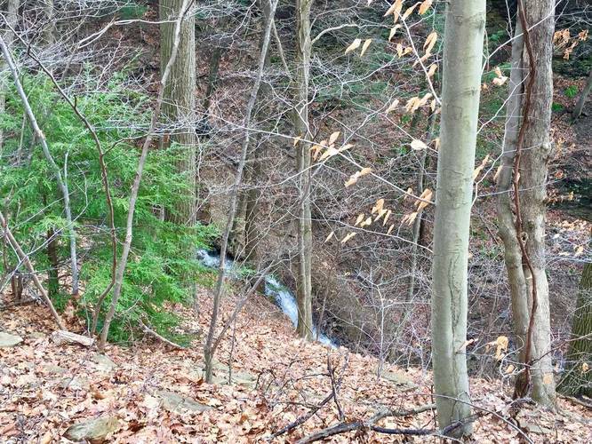
You can also see the base of the northeast waterfall from the main Fall Run Trail; however you cannot see the southern waterfall from the main trail at all.

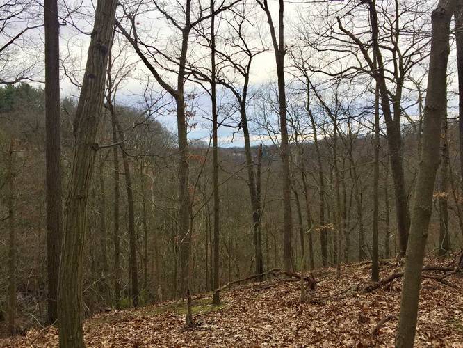
At the top of the hill, the trail just ends, but it's possible that you can access Laurelwood Drive if you keep hiking through the woods. When the leaves are not on the trees, you can also get a small glimpse of nearby neighborhoods on the hillsides.

Note: The northeast waterfall is not as easy to see from this trail and the lookout point, which is disappointing, but you can get glimpses of it.
Explore 220 trails near Glenshaw, PA
  1. Parking

    40.530309, -79.948118
  2. Main Trailhead

    40.533422, -79.945745
  3. View of the southern falls

    40.532742, -79.945206
    View of the southern falls
  4. View of the northern Falls

    40.532823, -79.944769
    View of the northern Falls
  5. View of the southern falls

    40.532742, -79.945206
    View of the southern falls
  6. Obstructed view from the top of the hill

    40.53305, -79.944681
    Obstructed view from the top of the hill
No community routes found. To add your own hike as a Community Route for this Trail guide, leave a Trip Report with an attached GPX file.

Hazards

Ticks - Lyme Disease More Info (CDC)
Rockfalls / Ledges / or Scrambles

Seasons

All

Photo Albums

Trip Reports

Trail Guide By:
Admin user profile picture
0.4 miles / 0.6 km
0.4 miles / 0.6 km
February 25, 2018
Hiking

Weather Forecast

In Glenshaw, PA

Explore Hiking Trails

You May Also Like

Colorado's Million Dollar Highway - Plan a day's drive adventure along the iconic Million Dollar Highway in Colorado. Explore the best short trails, roadside stops, waterfalls, vistas, ghost towns, and hot springs within a ~6 hour road trip.
Explore

Colorado's Million Dollar Highway

Plan a day's drive adventure along the iconic Million Dollar Highway in Colorado. Explore the best short trails, roadside stops, waterfalls, vistas, ghost towns, and hot springs within a ~6 hour road trip.

Read
New York's Best Waterfalls - Whether you're planning a day hike, roadside stop, or a leisurely short walk, this guide provides hikers, travelers, and locals alike with 63 different locations to over 100 scenic waterfalls to help plan your next adventure!
Explore

New York's Best Waterfalls

Whether you're planning a day hike, roadside stop, or a leisurely short walk, this guide provides hikers, travelers, and locals alike with 63 different locations to over 100 scenic waterfalls to help plan your next adventure!

Read

Before you boogie...

Find our trail guides useful? Consider becoming a Supporter to unlock perks!

MyHikes is an indie platform that makes exploring public trails easier for everyone. The platform has no investors, no ads, and is owned and operated by one person, Dave Miller. Dave has personally mapped and written over 1,800 trail guides on MyHikes for the public to explore. MyHikes has helped millions outdoor enthusiasts plan their next adventure.

But it takes a lot of time 🕦, money 💰, work, and espresso shots ☕ to run MyHikes, including hiking , mapping , writing , and publishing new trails with high-quality (accurate) information... along with software engineering (coding) the platform like building new features, website and mobile app development (iOS and Android), site maintainance . and much much more.

Supporters unlock website and mobile app perks with an annual one-time payment of $25 (you renew) 😎👍. Or you can simply make a Donation of your choice. Otherwise, you can support us by telling your friends about MyHikes - both quick and free 🎉

Admin user profile picture

Dave Miller
MyHikes Founder