Fall Run Falls at Tioga State Forest near Cedar Run, Pennsylvania is a moderate 1.5-mile out-and-back creek bushwhack hike that leads to the ultra-secluded 25-foot tall waterfall, Fall Run Falls.
Bushwhack & Creek Hiking
Note that this hike does not follow any trails and does not have a trailhead, so anyone attempting to explore Fall Run Falls should have plenty of previous bushwhacking, creek hiking, and land navigation experience. This hike is not for the inexperienced hiker but rather the experienced creek-walker and bushwhacker. Also note that the GPS track on the map does not follow the creek exactly; however, you will follow the creek - the data is just slightly off based on the approximations of where the creek is.
Hike Description
This hike beings along Leetonia Road near the coordinates provided and hikers will start off by heading down a very steep hillside that leads to Cedar Run creek. Once at Cedar Run, hikers will follow the creek upstream until you reach Fall Run creek.
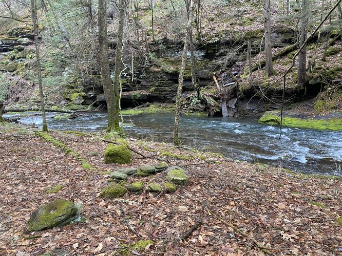
The hike up Cedar Run isn't much to write about; however, hikers will pass some massive cliffs (approximately 50-feet tall) where water trickles down, plenty of moss-covered rocks, some swimming holes along the way, and if you're lucky you'll get some neat fog that hovers over the water.
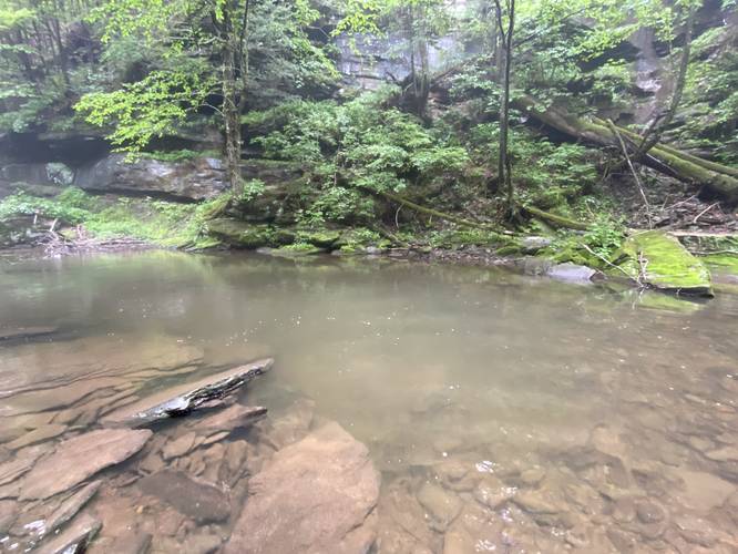
Swimming Hole - Mile 0.62
Around mile 0.62, hikers will find a deep swimming hole in Cedar Run, surrounding by steep cliffs.
Fall Run Creek - Mile 0.7
At mile 0.7, hikers will reach Fall Run creek, located on the west side of Cedar Run. Hike up this creek to reach Fall Run Falls.
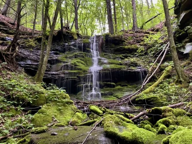
Fall Run Falls (25-feet tall) - Mile 0.73
Around mile 0.73, hikers will reach the base of Fall Run Falls. Fall Run Falls cascades down about 25 vertical feet over moss-covered shale bedrock. The rock ledge is covered in moss along with the rocks and boulders below that the stream flows through to reach Cedar Run. Fall Run Falls is also surrounded by some rock cliffs on either side, which makes for really beautiful and secluded scenery. During our July hike here, the moss, nettles, and greenery of the trees really made for a lush and remote landscape to enjoy.
After visiting Fall Run Falls, the hike back is identical but opposite to the hike in. By the time you reach the car, you will have hiked approximately 1.45-miles and most of that is over slick, slippery, and tricky footing in the creek. Hikers should go slow, take their time, and use their trekking poles to ensure the best footing while traversing Cedar Run.
Parking
Hikers will find no parking lot or real parking turnout for this hike; however, there's enough room on the side of the road to fit a vehicle to park. Just watch out for the super-steep hillside when pulling off the road.
Camping & Backpacking
Primitive / dispersed / backcountry camping is allowed per state forest rules and regulations. Please follow all state forest rules and regulations if planning to camp.
Time to Hike
Hikers should plan for about 2-hours to do this hike as the traverse up and down Cedar Run is very slow at best.
Warnings
No cell service: This hike has no cell service at all, which can be scary if you get hurt while out in the woods. Once you're down in the steep gorge-like terrain of Cedar Run, it'd be hard to call for help if you got injured.
Slippery creek rocks: This hike follows Cedar Run creek for 90% of the walk, which is filled with slick, slippery rocks. Watch your step and bring trekking poles to aid in the traverse.
Fast water / deep holes: Cedar Run has some fast-moving water and deep holes (even for swimming); however, hikers should be aware of these things to stay clear of them where necessary.
Timber Rattlesnakes: This area is home to the Timber Rattlesnake who tends to sunbathe in tall creek-side grasses or hunt along streams and creeks. Be on the lookout for any and give any rattlesnakes you find plenty of space.
Special Thanks
Special thanks to my wife, Nina, who spotted this waterfall while on a waterfall scouting drive in early 2023. Fall Run Falls, being as remote as it is, is seldomly visited and rightfully so. If you pull the trigger to check this waterfall out, I hope you enjoy it as much as I did on my first trip.
Bushwhack & Creek Hiking
Note that this hike does not follow any trails and does not have a trailhead, so anyone attempting to explore Fall Run Falls should have plenty of previous bushwhacking, creek hiking, and land navigation experience. This hike is not for the inexperienced hiker but rather the experienced creek-walker and bushwhacker. Also note that the GPS track on the map does not follow the creek exactly; however, you will follow the creek - the data is just slightly off based on the approximations of where the creek is.
Hike Description
This hike beings along Leetonia Road near the coordinates provided and hikers will start off by heading down a very steep hillside that leads to Cedar Run creek. Once at Cedar Run, hikers will follow the creek upstream until you reach Fall Run creek.
The hike up Cedar Run isn't much to write about; however, hikers will pass some massive cliffs (approximately 50-feet tall) where water trickles down, plenty of moss-covered rocks, some swimming holes along the way, and if you're lucky you'll get some neat fog that hovers over the water.
Swimming Hole - Mile 0.62
Around mile 0.62, hikers will find a deep swimming hole in Cedar Run, surrounding by steep cliffs.
Fall Run Creek - Mile 0.7
At mile 0.7, hikers will reach Fall Run creek, located on the west side of Cedar Run. Hike up this creek to reach Fall Run Falls.
Fall Run Falls (25-feet tall) - Mile 0.73
Around mile 0.73, hikers will reach the base of Fall Run Falls. Fall Run Falls cascades down about 25 vertical feet over moss-covered shale bedrock. The rock ledge is covered in moss along with the rocks and boulders below that the stream flows through to reach Cedar Run. Fall Run Falls is also surrounded by some rock cliffs on either side, which makes for really beautiful and secluded scenery. During our July hike here, the moss, nettles, and greenery of the trees really made for a lush and remote landscape to enjoy.
After visiting Fall Run Falls, the hike back is identical but opposite to the hike in. By the time you reach the car, you will have hiked approximately 1.45-miles and most of that is over slick, slippery, and tricky footing in the creek. Hikers should go slow, take their time, and use their trekking poles to ensure the best footing while traversing Cedar Run.
Parking
Hikers will find no parking lot or real parking turnout for this hike; however, there's enough room on the side of the road to fit a vehicle to park. Just watch out for the super-steep hillside when pulling off the road.
Camping & Backpacking
Primitive / dispersed / backcountry camping is allowed per state forest rules and regulations. Please follow all state forest rules and regulations if planning to camp.
Time to Hike
Hikers should plan for about 2-hours to do this hike as the traverse up and down Cedar Run is very slow at best.
Warnings
No cell service: This hike has no cell service at all, which can be scary if you get hurt while out in the woods. Once you're down in the steep gorge-like terrain of Cedar Run, it'd be hard to call for help if you got injured.
Slippery creek rocks: This hike follows Cedar Run creek for 90% of the walk, which is filled with slick, slippery rocks. Watch your step and bring trekking poles to aid in the traverse.
Fast water / deep holes: Cedar Run has some fast-moving water and deep holes (even for swimming); however, hikers should be aware of these things to stay clear of them where necessary.
Timber Rattlesnakes: This area is home to the Timber Rattlesnake who tends to sunbathe in tall creek-side grasses or hunt along streams and creeks. Be on the lookout for any and give any rattlesnakes you find plenty of space.
Special Thanks
Special thanks to my wife, Nina, who spotted this waterfall while on a waterfall scouting drive in early 2023. Fall Run Falls, being as remote as it is, is seldomly visited and rightfully so. If you pull the trigger to check this waterfall out, I hope you enjoy it as much as I did on my first trip.