The Escalante Petrified Wood Loop at Escalante Petrified Forest State Park in Escalante, Utah is a moderate 1.5-mile loop (lollipop) hike that features rocks of ancient petrified trees.
Do Not Collect
This trail exists so visitors can appreciate the natural beauty in the petrified forest. Do not collect or disturb the petrified wood so that future visitors can enjoy it as well.
Trails
This hike follows the Petrified Wood Trail.
Hike Description
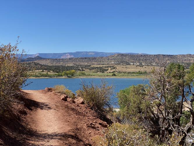
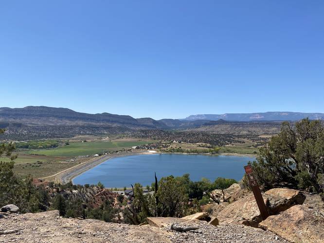
This hike begins at the parking lot for the petrified forest and main trail system at the park and heads uphill along the moderate grade of the main trail. The main trail that leads into the petrified forest is mostly open, with very-little shade, but also provides beautiful views as the hiker ascends (and descends) of the greater Escalante area including the Wide Hollow Reservoir just below your feet.
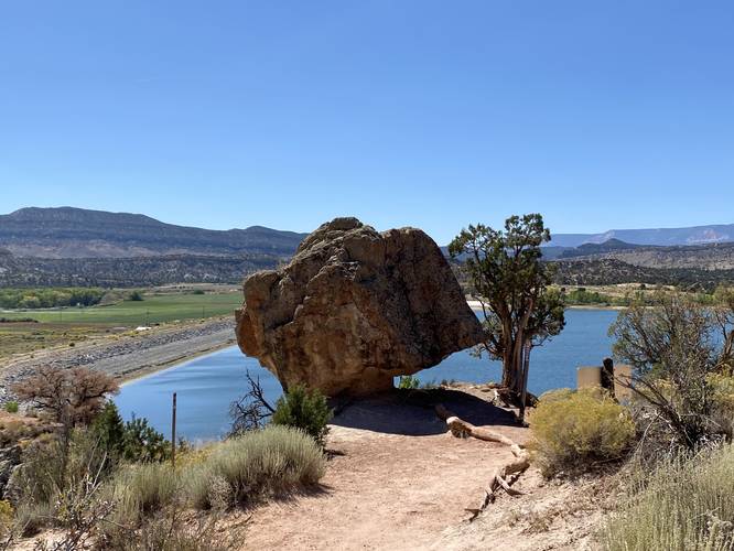
Balanced Rock - Mile 0.1
Around mile 0.1, just uphill from the switchbacks, is a rock called "Balanced Rock" -- you can see why if you hike past it and turn around toward the reservoir. The rock appears to teeter on one corner, like a balancing act.
Loop Junction, Keep Right - Mile 0.4
At mile 0.4, hikers will finally reach the flat plateau where the petrified forest is located. This hike will bring visitors along the shorter route, which includes pieces of trees (hence the Petrified Wood Trail name). You may not notice the petrified wood at first, but once you see a couple of pieces of it, you'll start to find more and more as you walk the trail.
Escalante View - Mile 0.45
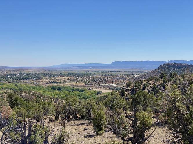
At mile 0.45, hikers will get a nice view into the town of Escalante, Utah.
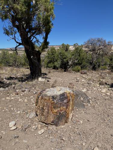
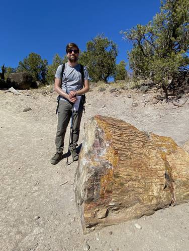
Petrified Forest Section #1 - Mile 0.55
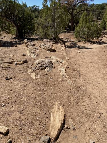
Around mile 0.55, hikers will reach the first section of petrified forest. You may almost miss the petrified wood as it's tan-ish and brown color blends into the trail's surface. Hikers may notice the fragmented rock, in the small outcropping that lines the trail for ~30-feet, broken into sections. This is an ancient tree, petrified into stone. I believe it's one tree that is semi-exposed, but I could be wrong -- hikers will notice near the "base" (closer to the bushes) that the structure is wider and becomes more and more narrow as it extends, which leads me to believe that it's simply one very-wide ancient tree. Regardless of one or many petrified trees, this is a neat sight but not the last section of petrified forest along the trail.
Trail of Sleeping Rainbows Junction - Mile 0.6
At mile 0.6, hikers will pass the Trail of Sleeping Rainbows to continue straight. If you have enough time, apparently the Trail of Sleeping Rainbows has free-standing petrified trees that hikers get to walk in between. We didn't have enough time that day, so we skipped that loop.
Eagle View Trail Junction - Mile 0.65
Around mile 0.65, hikers will pass the other end of the free-standing Petrified Forest loop by passing the Eagle View Trail -- continue straight.
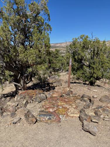
Petrified Forest Section #2 - Mile 0.8 to 0.9
Around mile 0.8, hikers will come across a "stump" of petrified wood, which appears to be a cross-cut section of an ancient tree-turned to stone. From mile 0.8 to 0.9 hikers will find a plethora of petrified wood scattered right along the trail.
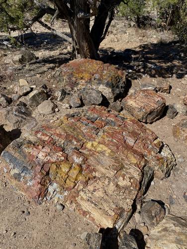
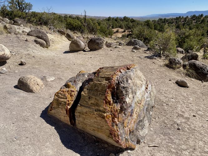
Petrified Forest Section #3 - Mile 1
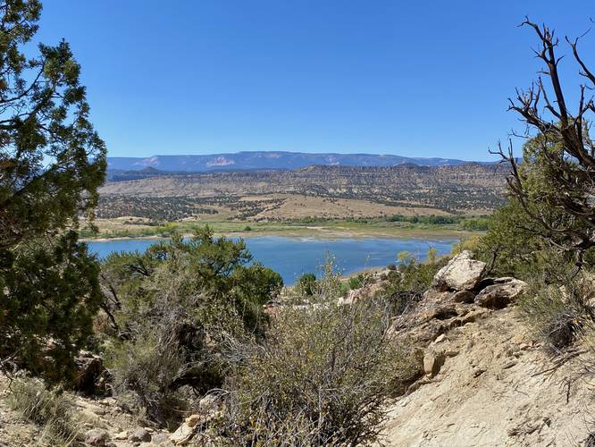
The best part of the hike and the most-impressive petrified wood that hikers will find along this loop is located around mile 1 and is best saved for last. At mile 1, hikers will find not only a beautiful vista of the Wide Hollow Reservoir, but they'll also find the largest and most-defined cross-cut of petrified wood. This massive cross-cut of ancient tree displays features like bark and fully-defined tree rings. The bark is unlike any other piece of petrified wood along the hike as it appears to be "untouched" as it transformed into stone. The stone is also multi-colored with shows the different parts of the tree, like the tree rings. This piece of petrified wood/forest is about 2.5-feet tall and 4-feet long.
After completing the loop, hikers will head down the moderate-grade of the main trail that they hiked on the way in, which leads back to parking to complete this 1.5-mile loop.
Parking
Hikers will find a small parking lot at the coordinates provided, located just behind the entrance building to the park. The lot is large enough to fit about a dozen vehicles as of September 2023.
Pets
Dogs are not allowed on this trail.
Fees
There's a $10 day use fee per vehicle as of September 2023.
Warnings
Sun exposure: This trail has very little shade and no water sources. Pack-in all water and wear sun screen and a hat to protect against sun exposure. It's smart to hike either in the early morning or late afternoon to avoid the intense desert sun.
No water: This trail has no water sources so you must pack-in all water. A general rule of thumb in the desert is 1 gallon of water per person per day.
Rattlesnakes: This is rattlesnake territory, so be on the lookout and give any rattlers you find plenty of space.
Do Not Collect
This trail exists so visitors can appreciate the natural beauty in the petrified forest. Do not collect or disturb the petrified wood so that future visitors can enjoy it as well.
Trails
This hike follows the Petrified Wood Trail.
Hike Description
This hike begins at the parking lot for the petrified forest and main trail system at the park and heads uphill along the moderate grade of the main trail. The main trail that leads into the petrified forest is mostly open, with very-little shade, but also provides beautiful views as the hiker ascends (and descends) of the greater Escalante area including the Wide Hollow Reservoir just below your feet.
Balanced Rock - Mile 0.1
Around mile 0.1, just uphill from the switchbacks, is a rock called "Balanced Rock" -- you can see why if you hike past it and turn around toward the reservoir. The rock appears to teeter on one corner, like a balancing act.
Loop Junction, Keep Right - Mile 0.4
At mile 0.4, hikers will finally reach the flat plateau where the petrified forest is located. This hike will bring visitors along the shorter route, which includes pieces of trees (hence the Petrified Wood Trail name). You may not notice the petrified wood at first, but once you see a couple of pieces of it, you'll start to find more and more as you walk the trail.
Escalante View - Mile 0.45
At mile 0.45, hikers will get a nice view into the town of Escalante, Utah.
Petrified Forest Section #1 - Mile 0.55
Around mile 0.55, hikers will reach the first section of petrified forest. You may almost miss the petrified wood as it's tan-ish and brown color blends into the trail's surface. Hikers may notice the fragmented rock, in the small outcropping that lines the trail for ~30-feet, broken into sections. This is an ancient tree, petrified into stone. I believe it's one tree that is semi-exposed, but I could be wrong -- hikers will notice near the "base" (closer to the bushes) that the structure is wider and becomes more and more narrow as it extends, which leads me to believe that it's simply one very-wide ancient tree. Regardless of one or many petrified trees, this is a neat sight but not the last section of petrified forest along the trail.
Trail of Sleeping Rainbows Junction - Mile 0.6
At mile 0.6, hikers will pass the Trail of Sleeping Rainbows to continue straight. If you have enough time, apparently the Trail of Sleeping Rainbows has free-standing petrified trees that hikers get to walk in between. We didn't have enough time that day, so we skipped that loop.
Eagle View Trail Junction - Mile 0.65
Around mile 0.65, hikers will pass the other end of the free-standing Petrified Forest loop by passing the Eagle View Trail -- continue straight.
Petrified Forest Section #2 - Mile 0.8 to 0.9
Around mile 0.8, hikers will come across a "stump" of petrified wood, which appears to be a cross-cut section of an ancient tree-turned to stone. From mile 0.8 to 0.9 hikers will find a plethora of petrified wood scattered right along the trail.
Petrified Forest Section #3 - Mile 1
The best part of the hike and the most-impressive petrified wood that hikers will find along this loop is located around mile 1 and is best saved for last. At mile 1, hikers will find not only a beautiful vista of the Wide Hollow Reservoir, but they'll also find the largest and most-defined cross-cut of petrified wood. This massive cross-cut of ancient tree displays features like bark and fully-defined tree rings. The bark is unlike any other piece of petrified wood along the hike as it appears to be "untouched" as it transformed into stone. The stone is also multi-colored with shows the different parts of the tree, like the tree rings. This piece of petrified wood/forest is about 2.5-feet tall and 4-feet long.
After completing the loop, hikers will head down the moderate-grade of the main trail that they hiked on the way in, which leads back to parking to complete this 1.5-mile loop.
Parking
Hikers will find a small parking lot at the coordinates provided, located just behind the entrance building to the park. The lot is large enough to fit about a dozen vehicles as of September 2023.
Pets
Dogs are not allowed on this trail.
Fees
There's a $10 day use fee per vehicle as of September 2023.
Warnings
Sun exposure: This trail has very little shade and no water sources. Pack-in all water and wear sun screen and a hat to protect against sun exposure. It's smart to hike either in the early morning or late afternoon to avoid the intense desert sun.
No water: This trail has no water sources so you must pack-in all water. A general rule of thumb in the desert is 1 gallon of water per person per day.
Rattlesnakes: This is rattlesnake territory, so be on the lookout and give any rattlers you find plenty of space.