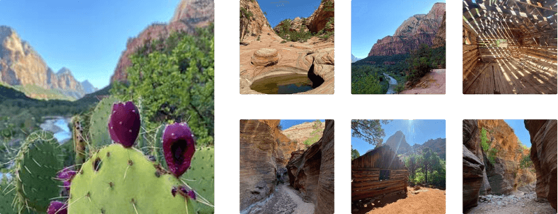
Emerald Pools via Kayenta Trail at Zion National Park near Springdale, Utah is a moderate 2.4-mile out-and-back hike that leads to desert pools and waterfalls and features stunning views of Zion Canyon and Zion Valley.
Parking Important note: Trailhead parking is only available during off-season months. For most seasons of the year, hikers must park outside of the Zion Canyon Scenic Drive, located along the road at a limited-number of parking spots located near (37.217472, -112.973270) and then you can hike to the trailhead or hop on a shuttle bus. Or hikers must park at the visitors center on the south side of the park, located (37.197994, -112.986847) and hop on a shuttle bus. Please refer to the Zion National Park website for all up-to-date information on when the shuttle service is running.
Hike Description
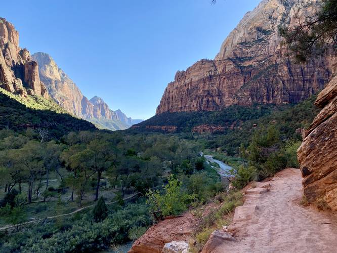
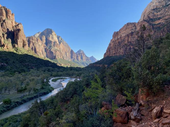
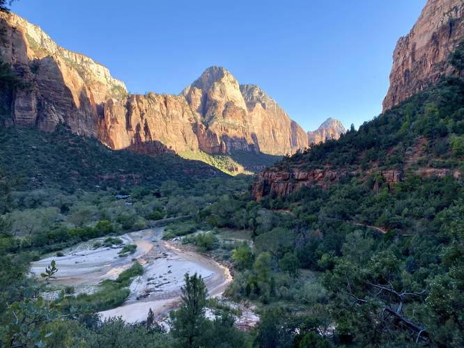
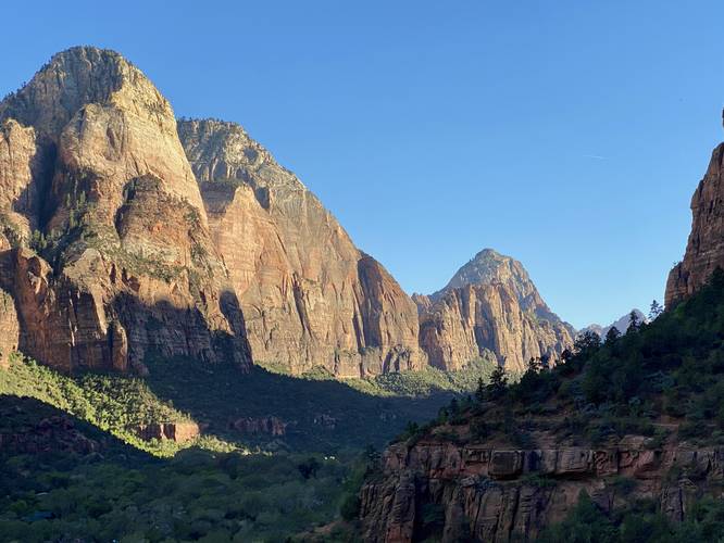
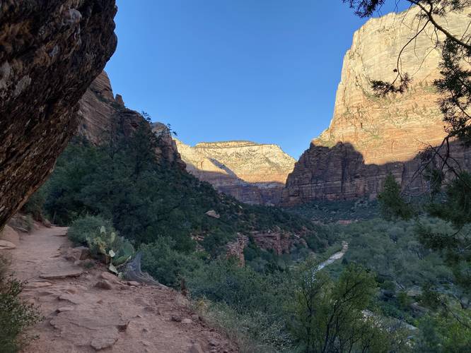
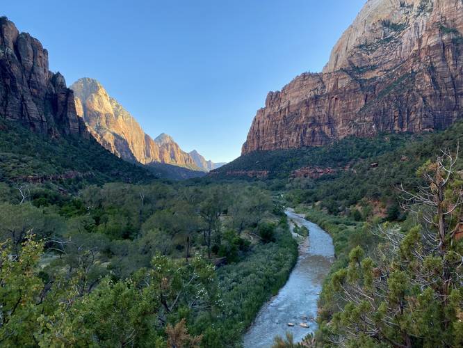
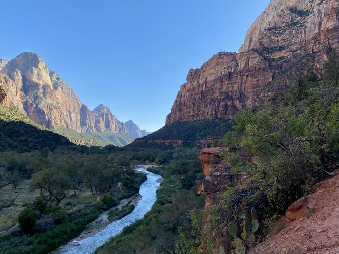
This hike begins at the Grotto shuttle stop and heads in on the main trailhead for the West Rim Trail and the Kayenta Trail. Hikers will cross the bridge spanning the Virgin River, which provides amazing views of the river and Zion Valley, before taking a left-hand turn to begin hiking on the Kayenta Trail. Once on the Kayenta Trail, hikers will head south through Zion Canyon, hiking along steep cliffs with sheer drop-offs. Along the way, hikers will find stunning views of Zion Valley and Zion Canyon without having to put in much physical effort. The trail itself is fairly wide, with some exceptions near cliffs, and due to its popularity is usually pretty crowded. During our hike here, we showed up late in the day - closer to sunset, so the trail was actually fairly quiet (thankfully).
12-foot Waterfall - Mile 0.8
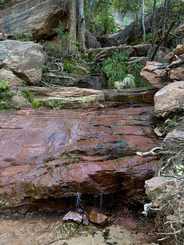
At mile 0.8, hikers will find a ~12-foot tall multi-tiered waterfall cascading down Zion Canyon, located essentially on-trail. This waterfall was mostly dried up during our hike here in late September 2023; however, after heavy rains or during periods of snow melt this waterfall is likely a lot more spectacular.
Turn to Lower Emerald Pools / Seasonal Waterfalls - Mile 0.85
Around mile 0.85, after hiking down a staircase that cuts through two massive rockfall boulders, hikers will find a left-hand turn that leads to the Lower Emerald Pools and large waterfalls. Note that this GPS track does not descend the 2nd set of stairs to reach Lower Emerald Pools (as we skipped that section on this hike), but it would add about 0.5-miles total to the distance to hike out-and-back. Note that during late September, 2023, there were no waterfalls cascading over the Middle Emerald Pools cliff, so the Lower Emerald Pools area was less attractive at the time. After periods of heavy rain or snow melt, those cliff waterfalls, that spill into Lower Emerald Pools, are well-worth hiking to.
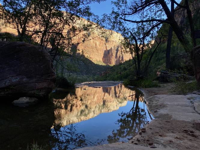
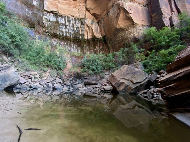
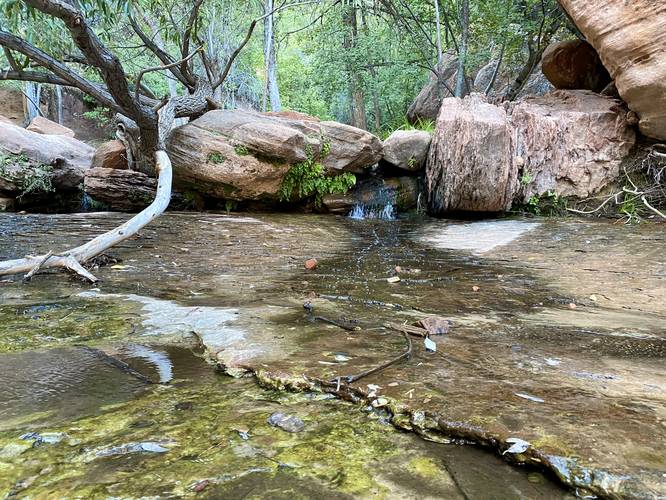
Middle Emerald Pools - Mile 0.9
Skipping Lower Emerald Pools, hikers will reach Middle Emerald Pools around mile 0.9. Here, you'll find a reflection pool sitting at the edge of the cliff in addition to a desert creek that flows down the hill behind you. There's a very small ~2-foot waterfall/cascade that spills down the bedrock and connects two pools. Above the small waterfall is a hidden Emerald Pool -- by far the greenest pool of water we found on our hike. Most hikers didn't even know this Emerald Pool existed as very few people, if any, found interest in poking around upstream.
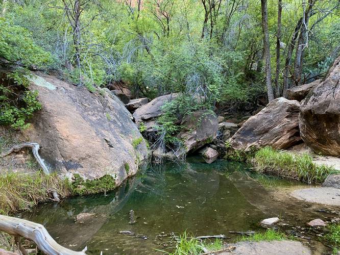
Upper Emerald Pool - Mile 1.2
After visiting Middle Emerald Pools, hikers will follow the trail heading southwest to reach a right-hand turn that follows a spur trail leading uphill to reach Upper Emerald Pools. This trail is by far the hardest part of the hike as the elevation grade becomes steeper than the trail that led in; however, it's not more difficult than moderate. Hikers will reach the Upper Emerald Pool around mile 1.2. The pool of water had a green tint to it and appeared to be fairly deep (at least 5 feet or so in the back). Upper Emerald Pool is the last stop for this hike, so the hike out begins here.
Hiking Out - Mile 1.2 to 2.4
The hike out follows the same path as the hike in. On your way out don't forget to take in the views of Zion Canyon, Zion Valley, the Virgin River, and some potential wildlife like tarantulas that you might find along the trail.
Pets
Dogs are not allowed on this trail.
Fees
Zion National Park has a $35/week entry fee as of September 2023. Visitors are highly encouraged to purchase an annual National Parks pass before their trip to reduce entry fees (especially if you're passing through multiple parks) and to also speed-up the insanely-long line that leads into the park.
Warnings
Rockfalls / cliffs: Note that this trail follows steep cliffs with sheer drop-offs. Additionally, Zion Canyon is full of active rockfalls that can happen at any time without warning. While rockfalls along the Kayenta Trail might be rare, they are not out of the possibility of happening.
No swimming: The Emerald Pools are considered sacred places and thus swimming is not allowed. Do not enter, walk into, swim, or wade in the Emerald Pools.
Sun exposure: This trail has some shade, but not a lot. Hikers should come prepared with sun protection.
Lack of water: Despite there being a desert creek and pools of water, hikers should not drink or filter from these and instead pack-in all water for your hike. Plan to bring plenty of water, especially 1 gallon per hiker per day if planning to hike for long periods of time.
Parking Important note: Trailhead parking is only available during off-season months. For most seasons of the year, hikers must park outside of the Zion Canyon Scenic Drive, located along the road at a limited-number of parking spots located near (37.217472, -112.973270) and then you can hike to the trailhead or hop on a shuttle bus. Or hikers must park at the visitors center on the south side of the park, located (37.197994, -112.986847) and hop on a shuttle bus. Please refer to the Zion National Park website for all up-to-date information on when the shuttle service is running.
Hike Description
This hike begins at the Grotto shuttle stop and heads in on the main trailhead for the West Rim Trail and the Kayenta Trail. Hikers will cross the bridge spanning the Virgin River, which provides amazing views of the river and Zion Valley, before taking a left-hand turn to begin hiking on the Kayenta Trail. Once on the Kayenta Trail, hikers will head south through Zion Canyon, hiking along steep cliffs with sheer drop-offs. Along the way, hikers will find stunning views of Zion Valley and Zion Canyon without having to put in much physical effort. The trail itself is fairly wide, with some exceptions near cliffs, and due to its popularity is usually pretty crowded. During our hike here, we showed up late in the day - closer to sunset, so the trail was actually fairly quiet (thankfully).
12-foot Waterfall - Mile 0.8
At mile 0.8, hikers will find a ~12-foot tall multi-tiered waterfall cascading down Zion Canyon, located essentially on-trail. This waterfall was mostly dried up during our hike here in late September 2023; however, after heavy rains or during periods of snow melt this waterfall is likely a lot more spectacular.
Turn to Lower Emerald Pools / Seasonal Waterfalls - Mile 0.85
Around mile 0.85, after hiking down a staircase that cuts through two massive rockfall boulders, hikers will find a left-hand turn that leads to the Lower Emerald Pools and large waterfalls. Note that this GPS track does not descend the 2nd set of stairs to reach Lower Emerald Pools (as we skipped that section on this hike), but it would add about 0.5-miles total to the distance to hike out-and-back. Note that during late September, 2023, there were no waterfalls cascading over the Middle Emerald Pools cliff, so the Lower Emerald Pools area was less attractive at the time. After periods of heavy rain or snow melt, those cliff waterfalls, that spill into Lower Emerald Pools, are well-worth hiking to.
Middle Emerald Pools - Mile 0.9
Skipping Lower Emerald Pools, hikers will reach Middle Emerald Pools around mile 0.9. Here, you'll find a reflection pool sitting at the edge of the cliff in addition to a desert creek that flows down the hill behind you. There's a very small ~2-foot waterfall/cascade that spills down the bedrock and connects two pools. Above the small waterfall is a hidden Emerald Pool -- by far the greenest pool of water we found on our hike. Most hikers didn't even know this Emerald Pool existed as very few people, if any, found interest in poking around upstream.
Upper Emerald Pool - Mile 1.2
After visiting Middle Emerald Pools, hikers will follow the trail heading southwest to reach a right-hand turn that follows a spur trail leading uphill to reach Upper Emerald Pools. This trail is by far the hardest part of the hike as the elevation grade becomes steeper than the trail that led in; however, it's not more difficult than moderate. Hikers will reach the Upper Emerald Pool around mile 1.2. The pool of water had a green tint to it and appeared to be fairly deep (at least 5 feet or so in the back). Upper Emerald Pool is the last stop for this hike, so the hike out begins here.
Hiking Out - Mile 1.2 to 2.4
The hike out follows the same path as the hike in. On your way out don't forget to take in the views of Zion Canyon, Zion Valley, the Virgin River, and some potential wildlife like tarantulas that you might find along the trail.
Pets
Dogs are not allowed on this trail.
Fees
Zion National Park has a $35/week entry fee as of September 2023. Visitors are highly encouraged to purchase an annual National Parks pass before their trip to reduce entry fees (especially if you're passing through multiple parks) and to also speed-up the insanely-long line that leads into the park.
Warnings
Rockfalls / cliffs: Note that this trail follows steep cliffs with sheer drop-offs. Additionally, Zion Canyon is full of active rockfalls that can happen at any time without warning. While rockfalls along the Kayenta Trail might be rare, they are not out of the possibility of happening.
No swimming: The Emerald Pools are considered sacred places and thus swimming is not allowed. Do not enter, walk into, swim, or wade in the Emerald Pools.
Sun exposure: This trail has some shade, but not a lot. Hikers should come prepared with sun protection.
Lack of water: Despite there being a desert creek and pools of water, hikers should not drink or filter from these and instead pack-in all water for your hike. Plan to bring plenty of water, especially 1 gallon per hiker per day if planning to hike for long periods of time.