Loading...

๐ŸŽ† 50% off 4th of July sale on Supporter Accounts โ€” now through July 6! Learn More.

Edwards Lake Cliffs & Pocket Falls

Directions
Map
Pictures
Send to App
Distance:
1.8 Miles / 2.9 km
Type:
Loop
Difficulty:
Easy
Time to Hike:
~54 minutes
Features:
Surface Type:
Dirt
Park:
Edwards Lake Cliffs Preserve
Town:
Ithaca, New York
Directions:
42.521062, -76.516356
Added:
November 03, 2024
Updated:
December 19, 2024
Copy Trail Link Hiking this trail? Send a friend or family member a link to this trail guide for your own safety. Hike at your own risk (disclaimer)
Loading...
Loading...
216'

Total Change
284'

Ascent
291'

Descent

Download the Trail Route for Offline Use

Supporters get exclusive access to download trail routes to the MyHikes app for offline use. Stay prepared on your adventure, even without an internet connection! Become a Supporter today to unlock this feature and hike with confidence.

Send to App

Edwards Lake Cliffs & Pocket Falls

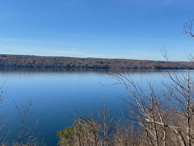
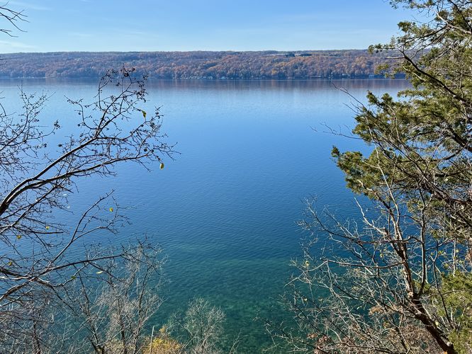
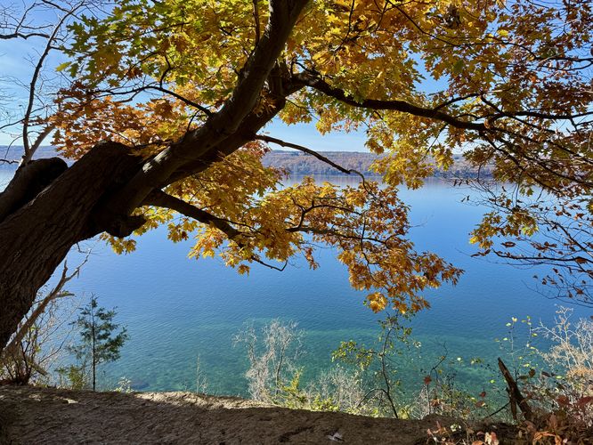
Edwards Lake Cliffs & Pocket Falls at Edwards Lake Cliffs Preserve in Ithaca, New York is an easy 1.8-mile loop hike that leads to the top of a 60-foot tall gorge waterfall, Pocket Falls, and leads to cliff views high above Cayuga Lake from Edwards Lake Cliffs.

Trails

This hike follows several named trails in the following order: Main Trail (red blazes), Pocket Falls Trail (blue blazes), Lake View Trail (yellow blazes).

Hiking Edwards Lake Cliffs Loop

This hike begins at the main parking area for Edwards Lake Cliffs Natural Area where the main trail lead into an open meadow where hikers will find an information kiosk with a trail map. This route heads to Pocket Falls first by following the Main Trail (red blazes) as it leads northward.

The Main Trail is easy to follow north as it passes through a "tunnel" of low-growing bushes before popping out to another open field. At the 2nd open field sits the trailhead for the Pocket Falls Trail (blue blazes). The route takes this right-hand turn to head toward Pocket Falls

Hiking to Pocket Falls - Mile 0.25 to 0.5

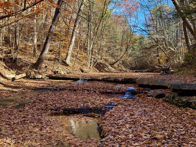
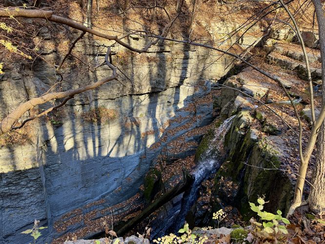
Around mile 0.25, hikers will take the right-hand turn onto the Pocket Falls Trail as it heads through the forest leading downhill. The trail winds north before cutting west and "ends" along Gulf Creek around mile 0.5. At Gulf Creek, hikers will find an unofficial trail that runs along the top of the 60-foot deep rocky gorge within the creek and out to a view of Pocket Falls. Pocket Falls plummets into this very deep rock gorge at about 60-feet tall in total, with a couple of tiers of cascades below the very-top. It's difficult to get a good view of the waterfall due to bushes and the extreme danger of being next to this massive gorge cliff, so watch your step and stay back from the edge at all times for your own safety. Before leaving Pocket Falls, you may notice some very small cascades located in the bedrock in Gulf Creek upstream from the big waterfall -- while these small cascades are nothing compared to the 60-foot Pocket Falls, they add to the scenery.

Hiking to Edwards Lake Cliffs from Pocket Falls - Mile 0.5 to 1.27

The hike to Edwards Lake Cliffs from Pocket Falls is fairly simple -- head back up the Pocket Falls Trail to reach the Main Trail once again. Once on the Main Trail, hike west until you reach a junction with yellow blazes. The yellow blazes indicate that you've located the Lake View Trail -- take this trail and keep-right as you navigate the forest to head downhill toward Cayuga Lake. Eventually, the trail will reach a dry run (seasonal waterfall below) around mile 1.25 -- here, you'll also find a nice view of Cayuga Lake from the top of the bedrock where the seasonal waterfall would normally flow into the lake. Here, you've reached Edwards Lake Cliffs. There are a couple of views of Cayuga Lake from Edwards Lake Cliffs -- some of which include turquoise-colored water just below your feet. During autumn, the color combination of turning foliage and the waters of Cayuga Lake make for a stunning sight. At the end of the trail you'll find a fence that separates public from private property along with a very large tree that sits on the edge of Edwards Lake Cliffs. View from here are great as well.

Edwards Lake Cliffs to Parking - Mile 1.27 to 1.8

The hike back to parking is simple -- hike east along the Lake View Trail to reach the red blazes of the Main Trail. Once on the Main Trail, complete the loop by hiking southeast where you'll reach the info kiosk and finally the trailhead around mile 1.8.

Parking

Hikers will find a small parking turnout at the coordinates provided, located along the western corner of Teeter Road in Ithaca. The turnout is large enough to fit about 6 vehicles as of November 2024.

Pets

Dogs are allowed only if leashed and must be cleaned up after.

Warning

Steep cliffs: This hike leads to steep terrain (cliffs) along Cayuga Lake. Watch your step and hike at your own risk.
Explore 43 trails near Ithaca, NY
  1. Parking

    42.521062, -76.516356
  2. Main Trailhead

    42.521062, -76.516356
  3. Small cascades within Gulf Creek

    42.524511, -76.515794
    Small cascades within Gulf Creek
  4. Pocket Falls (approx. 60-feet tall)

    42.524361, -76.516356
    Pocket Falls (approx. 60-feet tall)
  5. View of Cayuga Lake from Edwards Lake Cliffs

    42.520153, -76.521636
    View of Cayuga Lake from Edwards Lake Cliffs
  6. View of Cayuga Lake with turquoise waters below from Edwards Lake Cliffs

    42.519936, -76.521478
    View of Cayuga Lake with turquoise waters below from Edwards Lake Cliffs
  7. View of Cayuga Lake with turquoise waters below from Edwards Lake Cliffs

    42.519806, -76.521361
    View of Cayuga Lake with turquoise waters below from Edwards Lake Cliffs
No community routes found. To add your own hike as a Community Route for this Trail guide, leave a Trip Report with an attached GPX file.

Hazards

Ticks - Lyme Disease More Info (CDC)
Poison Ivy/Oak
Rockfalls / Ledges / or Scrambles

Seasons

All

Blaze Color

Red

Trip Reports

Trail Guide By:
Admin user profile picture
1.8 miles / 2.9 km
1.8 miles / 2.9 km
November 03, 2024
The waterfall and lake cliffs were cooler than anticipated especially the turquoise-tinted water in Cayuga Lake
Dogs Hiking

Weather Forecast

In Ithaca, NY

Explore Hiking Trails

You May Also Like

Colorado's Million Dollar Highway - Plan a day's drive adventure along the iconic Million Dollar Highway in Colorado. Explore the best short trails, roadside stops, waterfalls, vistas, ghost towns, and hot springs within a ~6 hour road trip.
Explore

Colorado's Million Dollar Highway

Plan a day's drive adventure along the iconic Million Dollar Highway in Colorado. Explore the best short trails, roadside stops, waterfalls, vistas, ghost towns, and hot springs within a ~6 hour road trip.

Read
Glacier's Going-to-the-Sun Road - Discover the breathtaking beauty of Glacier National Park along the iconic Going-to-the-Sun Road. From stunning roadside stops to picturesque waterfalls and vistas, this engineering marvel offers endless opportunities for exploration.
Explore

Glacier's Going-to-the-Sun Road

Discover the breathtaking beauty of Glacier National Park along the iconic Going-to-the-Sun Road. From stunning roadside stops to picturesque waterfalls and vistas, this engineering marvel offers endless opportunities for exploration.

Read
New York's Best Waterfalls - Whether you're planning a day hike, roadside stop, or a leisurely short walk, this guide provides hikers, travelers, and locals alike with 63 different locations to over 100 scenic waterfalls to help plan your next adventure!
Explore

New York's Best Waterfalls

Whether you're planning a day hike, roadside stop, or a leisurely short walk, this guide provides hikers, travelers, and locals alike with 63 different locations to over 100 scenic waterfalls to help plan your next adventure!

Read

Before you boogie...

Find our trail guides useful? Consider becoming a Supporter to unlock perks!

MyHikes is an indie platform that makes exploring public trails easier for everyone. The platform has no investors, no ads, and is owned and operated by one person, Dave Miller. Dave has personally mapped and written over 1,800 trail guides on MyHikes for the public to explore. MyHikes has helped millions outdoor enthusiasts plan their next adventure.

But it takes a lot of time ๐Ÿ•ฆ, money ๐Ÿ’ฐ, work, and espresso shots โ˜• to run MyHikes, including hiking , mapping , writing , and publishing new trails with high-quality (accurate) information... along with software engineering (coding) the platform like building new features, website and mobile app development (iOS and Android), site maintainance . and much much more.

Supporters unlock website and mobile app perks with an annual one-time payment of $25 (you renew) ๐Ÿ˜Ž๐Ÿ‘. Or you can simply make a Donation of your choice. Otherwise, you can support us by telling your friends about MyHikes - both quick and free ๐ŸŽ‰

Admin user profile picture

Dave Miller
MyHikes Founder