Loading...

Distance:
0.1 Miles / 0.2 km
Type:
Loop
Difficulty:
Easy
Time to Hike:
~5 minutes
Features:
Surface Type:
Dirt
Town:
Eastham, Massachusetts
Directions:
41.830207, -69.975292
Added:
April 07, 2023
Updated:
April 07, 2023
Loading...
Loading...
1 '

Total Change
1 '

Ascent
1 '

Descent

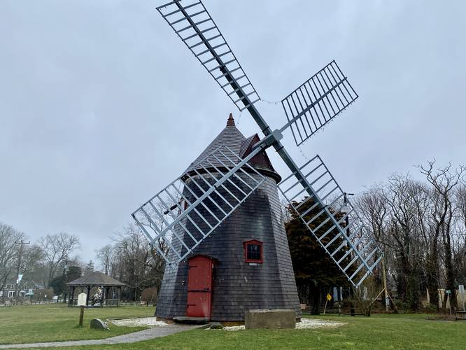
The Eastham Windmill in Eastham, Massachusetts is an easy 0.1-mile loop walk that leads through the Windmill Green common and features views of the historical windmill.

This is not a hike, but rather a very short flat walk that features the Eastham Windmill. The windmill has several unique features around each side, so it's worth checking out from all angles. Some historical information can be found on-site along with an old stone horse trough.

History
The Eastham Windmill is Cape Cod's oldest windmill - built in Plymouth, MA 1680 by Thomas Paine of Eastham. Moved to Truro in 1770. Moved to Eastham in 1793. Moved to this location in 1808.

Parking
Visitors will find parking along Samoset Road near the coordinates provided. There are enough parking turnouts for about 10 vehicles, or a bit less.

Pets
Dogs are allowed only if leashed and cleaned up after.

Explore 39 trails near Eastham, MA
  1. Parking

    41.830207, -69.975292
  2. Main Trailhead

    41.830239, -69.975221
  3. Eastham Windmill (built 1680)

    41.830478, -69.974494
    Eastham Windmill (built 1680)
No community routes found. To add your own hike as a Community Route for this Trail guide, leave a Trip Report with an attached GPX file.

Hazards

Ticks - Lyme Disease More Info (CDC)

Seasons

All

Photo Albums

1 Trip Report

No Star-Ratings
Write-up by:
Admin user profile picture
0.1 miles / 0.2 km
Trail added
April 07, 2023
Hiked on
April 01, 2023
Updated on
April 07, 2023

Weather Forecast

In Eastham, MA

Explore Hiking Trails

New Hikes

Larry's Creek Trail
3.6 Miles
5.8 km
Moderate
Out-and-Back
Cottonwood Falls Loop
1.2 Miles
1.9 km
Moderate
Loop
Tibwin Plantation Trail
1.9 Miles
3.1 km
Easy
Out-and-Back
Weston Lake Loop
3.2 Miles
5.1 km
Easy
Loop

Before you leave...

MyHikes is an indie web platform aimed to make exploring public trails easier for everyone. The site has no investors and is owned and operated by one person, Dave Miller (Founder & Admin). As the Founder, main contributor, and doer-of-all-things for MyHikes, I share my trips with over-detailed write-ups for fun on a volunteer basis and I believe that public trail information should be available to everyone.

It takes a lot of time 🕦, money 💰, and effort (including espresso shots ☕) to run MyHikes, including hiking , mapping , writing , and publishing new trails with high-quality content... along with building new features, moderating, site maintainance, and app development for iOS and Android . I simply ask that if you find MyHikes' trail guides helpful to please consider becoming a Supporter to help keep the site, iOS, and Android apps available to everyone.

Supporters unlock website and in-app perks with a one-time payment of $25 (you renew) 😎👍. Or you can simply make a Donation of your choice without a MyHikes user account. Otherwise, telling your friends about MyHikes is the next-best thing - both quick and free 🎉

Thanks for visiting MyHikes and have a great hike!️

Admin user profile picture

Dave Miller
MyHikes Founder & Admin