East Royce Mountain at the White Mountain National Forest near Gilead, Maine is a difficult 3-mile out-and-back hike that leads to a stunning summit vista at the top of the mountain and features about four waterfalls (likely from seasonal snow-melt) which are located both on and off-trail.
Trails
This hike follows one named trail: East Royce Trail (yellow blazes).
Hike Description
This hike begins at the main parking lot for the East Royce Trail at the parking coordinates provided. As of late April 2022, the trailhead kiosk map did not include the summit portion of the trail that leads to the vista and ultimately summit; however, it's listed on most open source maps.
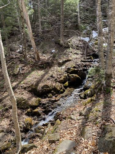
The trail immediately starts by crossing Evans Notch, which ultimately means crossing the small brook - Evans Brook. After crossing Evans Brook, the climb up East Royce Mountain begins along a moderate grade. Note that Evans Brook is just the first of about four creek crossings in total. After crossing Evans Brook, any creek/brook crossings from here on out are along the Cold River or Cold River tributary brooks. There are several waterfalls that feed the Cold River and some of them - Cold River Falls and East Royce Falls - are located off-trail and require bushwhacking. Also note that some of these cascades might be seasonal, mostly found in the Spring as the snow melts off of East Royce Mountain.
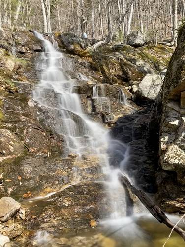
Cold River Falls - 45-foot Waterfall (bushwhack)
Just after crossing Evans Brook, hikers will pass a 45-foot tall waterfall. There wasn't any signage and I couldn't find much information on this waterfall, so I've decided to simply name it "Cold River Falls" since it's the largest waterfall along the named brook, Cold River. Just below this waterfall is where the Cold River joins Evans Brook before it flows south through Evans Notch. I bushwhacked to the base of the waterfall for a better view, before heading back to the trail.
Hikers will have to cross Cold River at the top of Cold River Falls, but even during the Spring's rushing snow-melt, it was not very difficult. The trail will continue climbing the eastern hollow of East Royce Mountain at a moderate grade and another off-trail waterfall can be found along the way.
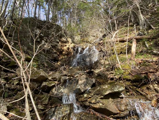
East Royce Falls - 60-foot Waterfall (bushwhack)
Around mile 0.25, hikers may notice the large multi-tiered waterfall cascading down the side of East Royce Mountain located in a rocky gorge behind the trees about 300 feet off-trail. Here, I bushwhacked over to what I decided to name "East Royce Falls". The waterfall has multiple tiers of cascades as it splashes down into a rocky gorge. Hikers may notice the unstable rock ledges where massive rocks have tumbled down in the past. The waterfall's view from the base is smaller than the 60-feet (or possibly more) that the waterfall reaches in height, since the rocky gorge bends to the right-hand side.
Rock Slide Falls - 10-foot Waterfall
Around mile 0.3 is yet another brook crossing at a tributary to the Cold River. Another small and skinny waterfall can be found here. There's a ~5-foot cascade that feeds into another ~5-foot tall and 10-foot long bedrock slide waterfall, which makes up "Rock Slide Falls".
Moss Slide Falls - 10-foot Waterfall
Around mile 0.4 is yet another creek crossing at another tributary that feeds Cold River. Here lies yet another waterfall which I decided to name "Moss Slide Falls". The cascade is approximately 10-feet tall and 15-feet wide that spills down a mossy granite rock. During late April 2022, the snow-melt along this tributary wasn't strong enough to splash over the entire rock face of the waterfall, but yet the bedrock ended up splitting the water into two paths - which makes for a scenic stop along the trail.
On-Trail (Seasonal) Vista - Mile 0.75
Around mile 0.75. hikers will pass a vista point that faces east with a stunning view of Haystack Mountain in the distance. Haystack Mountain's steep southeastern slopes make for a dramatic valley landscape - known as Haystack Notch. This vista may be slightly overgrown during the warmer months.
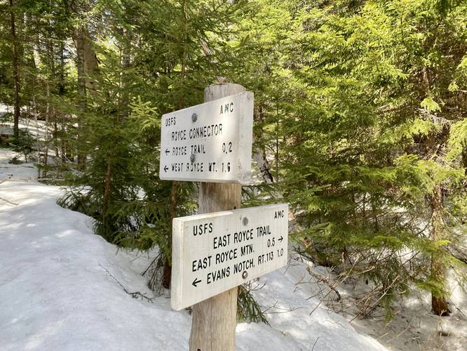
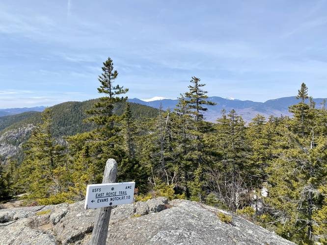
Junction to East Royce Mountain - Mile 1.1
Around mile 1.1, hikers will reach the junction for the East Royce Mountain summit. Take a right-hand turn here to continue up the mountain toward the vistas. Along the way, hikers will enter a mostly-evergreen forest which appeared to be filled with hemlock and spruce varieties, a rooty and rocky terrain, and moss-covered slabs of granite bedrock.
Bedrock Vista - Mile 1.25
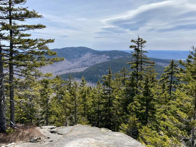
Around mile 1.25, hikers will reach the first year-round vista, located on granite bedrock, that features views of Spruce Hill and Speckled Mountain in the foreground. This is a great place to take a small break, especially if hikers are slowly descending the granite rock up the trail.
Light Rock Scrambling - Mile 1.3 to 1.4
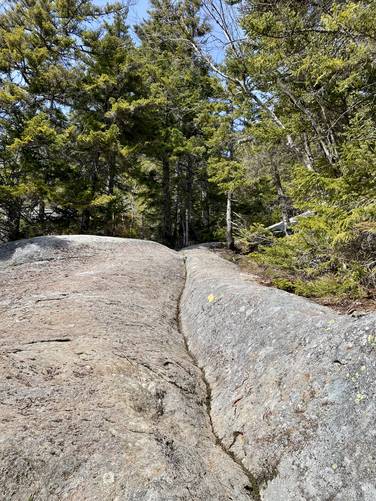
Just beyond the first bedrock vista lies some light rock scrambling to follow the trail. None of it is very difficult or dangerous, though it's worth noting. These rock scrambles are scattered between miles 1.3 and 1.4.
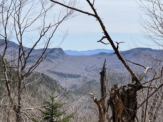
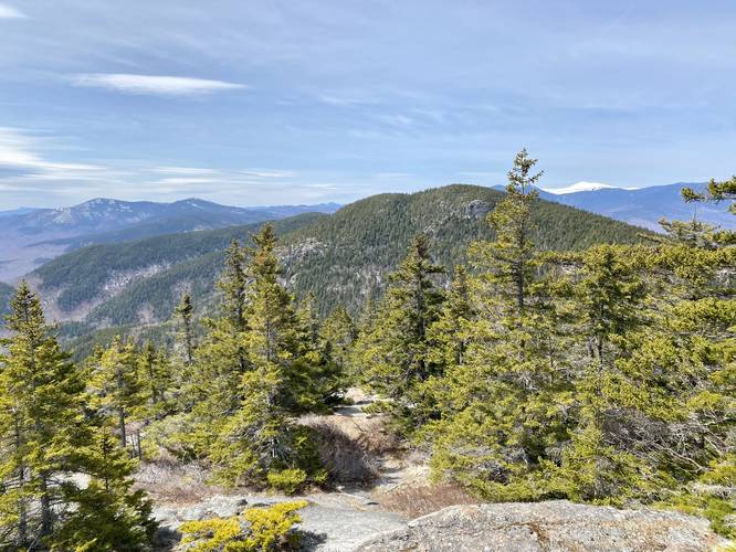
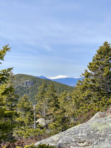
East Royce Mountain Summit Vista - Mile 1.45 to 1.5
Finally, hikers will reach the "summit" vistas along East Royce Mountain between miles 1.45 and 1.5, with the best views located at the end of the trail. The most open view area at the end of the trail peers toward West Royce Mountain with South Bald Face Mountain located in the background. If hikers look directly west, they'll find Mt. Washington in the distance. During the Spring and late Fall, Mt. Washington may be snow-capped, thus stands out like a sore thumb and makes it easy to find.
Unmaintained Trail to Official USGS Summit
Note that the trail technically continues to the official USGS summit of East Royce Mountain, where another vista apparently can be found. The bedrock (where this GPS recording ends) is a bit tall - maybe 15-feet tall - and slopes downward into an evergreen forest where this unmaintained trail continues. After dragging my wife up this mountain, post-holing into 2+ foot snowpack, we decided to turn back and not bushwhack to the summit.
Parking
Hikers will find a large parking lot at the coordinates provided on the north side of ME-113. The lot is large enough to fit about 12 vehicles.
Pets
Dogs are allowed if leashed and their waste should be carried out by the hiker.
Early Spring Hiking - Waterfalls and Post-holing
During the Spring, East Royce Mountain is generally very quiet. We hiked this mountain in late April, 2022 and the trail had snowpack which started just over half-way up the mountain. The snowpack was not difficult, but did slow us down quite a bit for various reasons. We opt'd out of carrying snowshoes up the mountain but found out that we needed them; however, after post-holing into 2-foot deep snow, with some pockets of space/rocks below (undermining), we realized we wished we carried snowshoes up the mountain. The snowpack actually can be dangerous if you make the wrong step and post-hole through deep snow / rock pockets potentially twisting or breaking an ankle. So if hiking in late the early Spring, you might want to bring snowshoes. Additionally, the trail is much easier to hike in the early Spring with ice spikes (or even hiking crampons especially in very-early Spring) since there's plenty of steep terrain with icy spots along the way. Last, it's hard to tell how much water flows off of East Royce Mountain during the Summer - since the National Forest guide does not mention waterfalls - however, these waterfall listed in this guide may only be seasonal. Two waterfalls are located off-trail to view their base - both Cold River Falls (closest to parking) and East Royce Falls (off-trail gorge waterfall) require some light bushwhacking.
Winter Access
This section of road is closed off with a gate during the winter - likely to keep snowmobiles and overzealous visitors from driving down the road. For this reason, this particular trail is essentially closed during winter months unless you have a snowmobile to reach the gate and then hike in to the trailhead. Please contact the national forest for seasonal road closure details.
Trails
This hike follows one named trail: East Royce Trail (yellow blazes).
Hike Description
This hike begins at the main parking lot for the East Royce Trail at the parking coordinates provided. As of late April 2022, the trailhead kiosk map did not include the summit portion of the trail that leads to the vista and ultimately summit; however, it's listed on most open source maps.
The trail immediately starts by crossing Evans Notch, which ultimately means crossing the small brook - Evans Brook. After crossing Evans Brook, the climb up East Royce Mountain begins along a moderate grade. Note that Evans Brook is just the first of about four creek crossings in total. After crossing Evans Brook, any creek/brook crossings from here on out are along the Cold River or Cold River tributary brooks. There are several waterfalls that feed the Cold River and some of them - Cold River Falls and East Royce Falls - are located off-trail and require bushwhacking. Also note that some of these cascades might be seasonal, mostly found in the Spring as the snow melts off of East Royce Mountain.
Cold River Falls - 45-foot Waterfall (bushwhack)
Just after crossing Evans Brook, hikers will pass a 45-foot tall waterfall. There wasn't any signage and I couldn't find much information on this waterfall, so I've decided to simply name it "Cold River Falls" since it's the largest waterfall along the named brook, Cold River. Just below this waterfall is where the Cold River joins Evans Brook before it flows south through Evans Notch. I bushwhacked to the base of the waterfall for a better view, before heading back to the trail.
Hikers will have to cross Cold River at the top of Cold River Falls, but even during the Spring's rushing snow-melt, it was not very difficult. The trail will continue climbing the eastern hollow of East Royce Mountain at a moderate grade and another off-trail waterfall can be found along the way.
East Royce Falls - 60-foot Waterfall (bushwhack)
Around mile 0.25, hikers may notice the large multi-tiered waterfall cascading down the side of East Royce Mountain located in a rocky gorge behind the trees about 300 feet off-trail. Here, I bushwhacked over to what I decided to name "East Royce Falls". The waterfall has multiple tiers of cascades as it splashes down into a rocky gorge. Hikers may notice the unstable rock ledges where massive rocks have tumbled down in the past. The waterfall's view from the base is smaller than the 60-feet (or possibly more) that the waterfall reaches in height, since the rocky gorge bends to the right-hand side.
Rock Slide Falls - 10-foot Waterfall
Around mile 0.3 is yet another brook crossing at a tributary to the Cold River. Another small and skinny waterfall can be found here. There's a ~5-foot cascade that feeds into another ~5-foot tall and 10-foot long bedrock slide waterfall, which makes up "Rock Slide Falls".
Moss Slide Falls - 10-foot Waterfall
Around mile 0.4 is yet another creek crossing at another tributary that feeds Cold River. Here lies yet another waterfall which I decided to name "Moss Slide Falls". The cascade is approximately 10-feet tall and 15-feet wide that spills down a mossy granite rock. During late April 2022, the snow-melt along this tributary wasn't strong enough to splash over the entire rock face of the waterfall, but yet the bedrock ended up splitting the water into two paths - which makes for a scenic stop along the trail.
On-Trail (Seasonal) Vista - Mile 0.75
Around mile 0.75. hikers will pass a vista point that faces east with a stunning view of Haystack Mountain in the distance. Haystack Mountain's steep southeastern slopes make for a dramatic valley landscape - known as Haystack Notch. This vista may be slightly overgrown during the warmer months.
Junction to East Royce Mountain - Mile 1.1
Around mile 1.1, hikers will reach the junction for the East Royce Mountain summit. Take a right-hand turn here to continue up the mountain toward the vistas. Along the way, hikers will enter a mostly-evergreen forest which appeared to be filled with hemlock and spruce varieties, a rooty and rocky terrain, and moss-covered slabs of granite bedrock.
Bedrock Vista - Mile 1.25
Around mile 1.25, hikers will reach the first year-round vista, located on granite bedrock, that features views of Spruce Hill and Speckled Mountain in the foreground. This is a great place to take a small break, especially if hikers are slowly descending the granite rock up the trail.
Light Rock Scrambling - Mile 1.3 to 1.4
Just beyond the first bedrock vista lies some light rock scrambling to follow the trail. None of it is very difficult or dangerous, though it's worth noting. These rock scrambles are scattered between miles 1.3 and 1.4.
East Royce Mountain Summit Vista - Mile 1.45 to 1.5
Finally, hikers will reach the "summit" vistas along East Royce Mountain between miles 1.45 and 1.5, with the best views located at the end of the trail. The most open view area at the end of the trail peers toward West Royce Mountain with South Bald Face Mountain located in the background. If hikers look directly west, they'll find Mt. Washington in the distance. During the Spring and late Fall, Mt. Washington may be snow-capped, thus stands out like a sore thumb and makes it easy to find.
Unmaintained Trail to Official USGS Summit
Note that the trail technically continues to the official USGS summit of East Royce Mountain, where another vista apparently can be found. The bedrock (where this GPS recording ends) is a bit tall - maybe 15-feet tall - and slopes downward into an evergreen forest where this unmaintained trail continues. After dragging my wife up this mountain, post-holing into 2+ foot snowpack, we decided to turn back and not bushwhack to the summit.
Parking
Hikers will find a large parking lot at the coordinates provided on the north side of ME-113. The lot is large enough to fit about 12 vehicles.
Pets
Dogs are allowed if leashed and their waste should be carried out by the hiker.
Early Spring Hiking - Waterfalls and Post-holing
During the Spring, East Royce Mountain is generally very quiet. We hiked this mountain in late April, 2022 and the trail had snowpack which started just over half-way up the mountain. The snowpack was not difficult, but did slow us down quite a bit for various reasons. We opt'd out of carrying snowshoes up the mountain but found out that we needed them; however, after post-holing into 2-foot deep snow, with some pockets of space/rocks below (undermining), we realized we wished we carried snowshoes up the mountain. The snowpack actually can be dangerous if you make the wrong step and post-hole through deep snow / rock pockets potentially twisting or breaking an ankle. So if hiking in late the early Spring, you might want to bring snowshoes. Additionally, the trail is much easier to hike in the early Spring with ice spikes (or even hiking crampons especially in very-early Spring) since there's plenty of steep terrain with icy spots along the way. Last, it's hard to tell how much water flows off of East Royce Mountain during the Summer - since the National Forest guide does not mention waterfalls - however, these waterfall listed in this guide may only be seasonal. Two waterfalls are located off-trail to view their base - both Cold River Falls (closest to parking) and East Royce Falls (off-trail gorge waterfall) require some light bushwhacking.
Winter Access
This section of road is closed off with a gate during the winter - likely to keep snowmobiles and overzealous visitors from driving down the road. For this reason, this particular trail is essentially closed during winter months unless you have a snowmobile to reach the gate and then hike in to the trailhead. Please contact the national forest for seasonal road closure details.