Loading...

📌 Love our trails? Set MyHikes as your preferred Google source. Add Now ⛰️

Eagles Crag via Cadillac South Ridge Trail

Trail name(s)

Eagle's Crag Loop Trail via Cadillac South Ridge Trail

Location

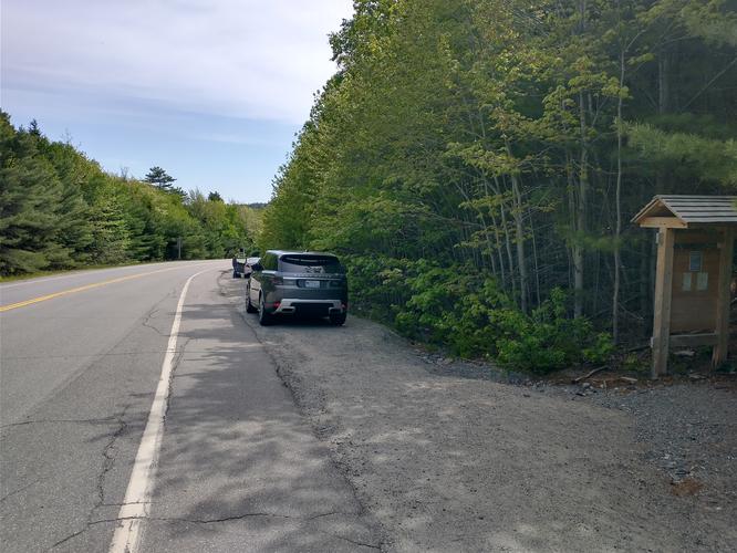
Acadia National Park, Mount Desert Isle, Maine, Route 3 across from Blackwood's Camping Entrance

Permitted uses

Hiking, Virtual Earthcaching, bird watching, nature study

Prohibited uses

No biking, No camping, No fires, No horses, No collecting of plants, rocks or animals, No feeding of wildlife. Do not build or add to any cairns along the trail. No use of drones

Hours

Parts of Acadia National Park are open year round and are open 24 hours a day. However, not all areas are accessible or staffed year round. It's best to check the park’s website and plan ahead for your visit. Follow the link below to find out if the area you want to visit is open during the time you want to visit.

https://www.nps.gov/acad/planyourvisit/hours.htm

Fees and Parking

There is no parking lot for this trailhead. There is a lot of room for street side parking on either side of the road. There is a fee to enter Acadia National Park. The fee schedule can be found at the park’s website or by following this link:

https://www.nps.gov/acad/planyourvisit/fees.htm

Pets

Dogs are allowed on the trails and must be kept on a leash that is not longer than 6 feet. Pets waste must be properly disposed of by the owner.

Accessibility

This hike is not wheelchair accessible and is going to be difficult for anyone with mobility challenges and balance problems.

Hiker amenities

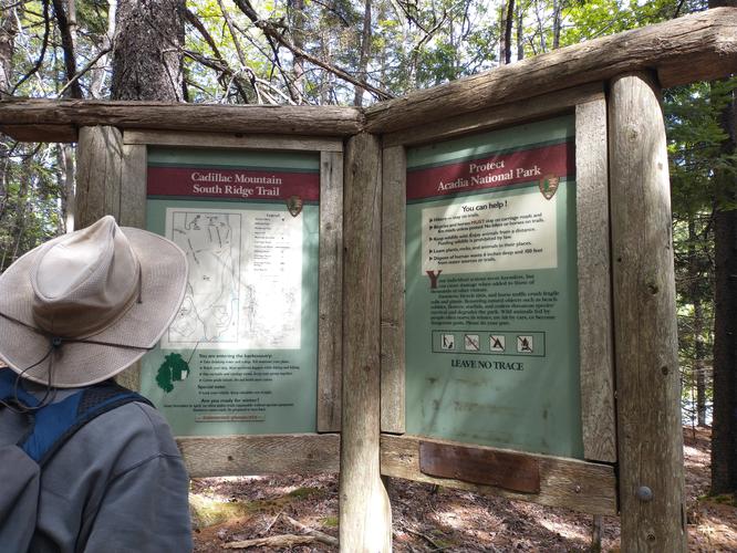
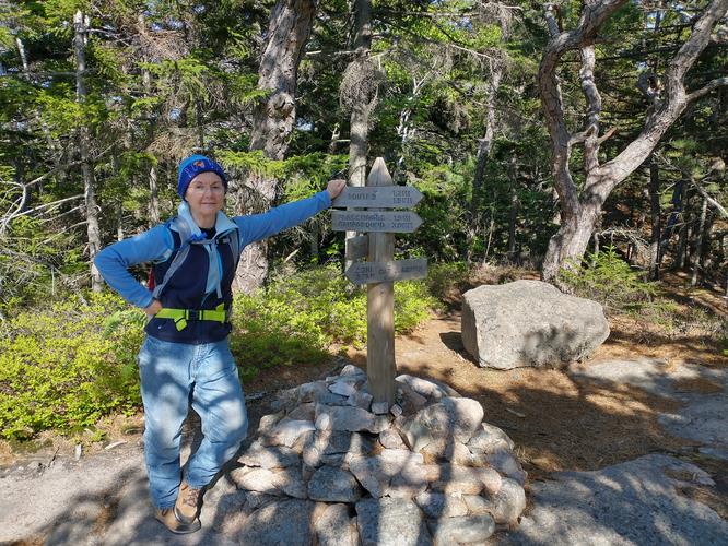
There is an information kiosk at the trailhead with a posted map of the trails. There are no restrooms or trash bins. Since there are no restrooms either at the trailhead or along the trails, human waste must be buried 6 inches deep and 100 feet from the trail or a water source.

Length and Trail information

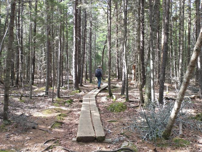
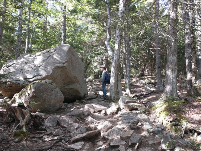
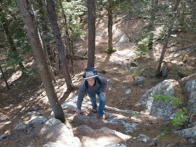
This hike was done as an out and back hike. The hike is 2.4 miles long and is a moderate hike due to the changes in elevation and the length of the hike. There are lots of trip hazards along the trail such as rocks and lots of protruding roots. There are also a couple of rock scrambles and some rocky ledges which were not too difficult and added to the fun and variety of the hike. The trail is marked by a blue blaze.

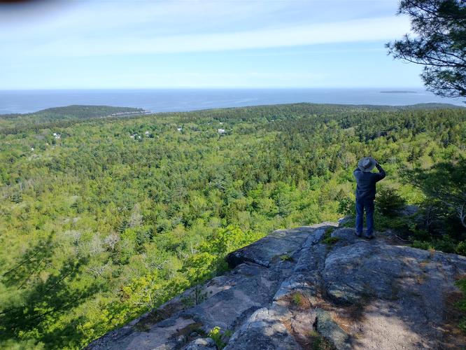
Our goal for this hike was to reach the summit of Eagle’s Crag and check out the views from the 702 foot rocky ledge. We took the Cadillac South Ridge Trail to Eagle’s Crag Loop Trail and after spending some time enjoying the beautiful views we headed back down the Cadillac South Ridge Trail.

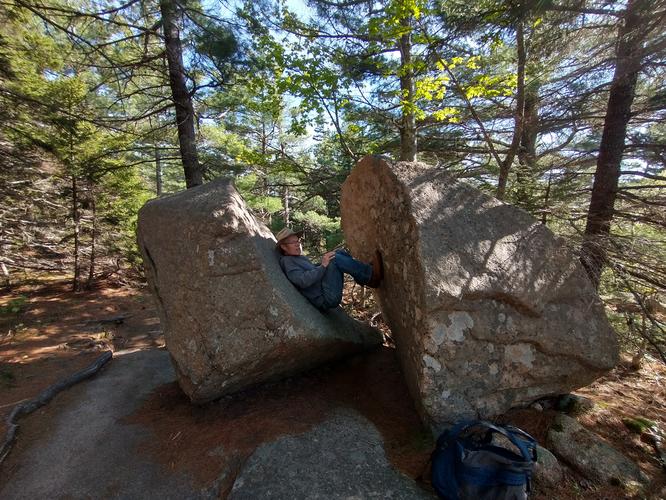
During the hike we enjoyed the challenges and the variety of conditions we encountered. We hiked up granite steps, over large log boardwalks, stony ledges flanked by blueberry bushes, tree roots so thick they reminded us of bulging veins. We encountered large and small glacial erratics, some steep rocky scrambles all nestled in a beautiful mixed dense forest.

Our efforts were rewarded with beautiful views of the valley below and the Atlantic Ocean in the distance.

Explore 21 trails near Bar Harbor, ME

Know Before You Go

  • This 2.4-mile out-and-back hike features moderate elevation changes, rocky ledges, and thick roots. You will encounter fun but steep rock scrambles and granite steps along the blue-blazed path.
  • There is no official parking lot, so you will need to park on the roadside near the Route 3 trailhead. Additionally, there are no restrooms or trash bins available, so pack out your trash and plan accordingly.
  • Dogs are welcome to join you on the trail but must be kept on a leash no longer than 6 feet at all times. Owners are strictly required to properly dispose of all pet waste.
Interactive topographic map for Eagles Crag via Cadillac South Ridge Trail located in Bar Harbor, ME. Click the "View Map" button to load GPS coordinates and trail markers.
Get directions
Distance
2.3 mi
Difficulty
Moderate
Type
Out-and-Back
Est. Time
1.2 hrs
Elev. Gain
539'
Rating
0.0
Added
June 10, 2026
Updated
July 03, 2026

Weather Forecast

Don't let Google decide who you trust.

Loading...
Total Change
522 ft.
159 m
Ascent
539 ft.
164 m
Descent
539 ft.
164 m
Loading...

Download the GPX Data for Offline Use

Supporters get exclusive access to download trail routes to the MyHikes app for offline use. Stay prepared on your adventure, even without an internet connection! Become a Supporter today to unlock this feature and hike with confidence.

Download Eagles Crag via Cadillac South Ridge Trail GPX Data to the MyHikes Mobile App

Features

Vista / Lookout Point
Dogs
Mountain Summit

Points of interest

  1. Parking

    44.312741, -68.214979
  2. Main Trailhead

    44.312774, -68.214885
  3. Roadside parking

    44.312764, -68.214758
    Roadside parking
  4. Information kiosk further along the trail

    44.312901, -68.214958
    Information kiosk further along the trail

Safety information

For your own safety: plan ahead, let someone know where you'll be, and hike at your own risk.

Hazards

Poison Ivy or Poison Oak
Rockfalls, Ledges, or Scrambles

Markers

Blaze Color

Blue

Blaze Dot Color

Blue

Availability

All seasons

Surface type

Dirt

Trip Reports (Reviews)

Your opinion matters! Be the first to rate this trail.

Ready to help fellow hikers? Add a trip report to share your experience!

No community routes found. To add your own hike as a Community Route for this Trail guide, leave a Trip Report with an attached GPX file.

You may also like

Colorado's Million Dollar Highway - Plan a day's drive adventure along the iconic Million Dollar Highway in Colorado. Explore the best short trails, roadside stops, waterfalls, vistas, ghost towns, and hot springs within a ~6 hour road trip.
Explore

Colorado's Million Dollar Highway

Plan a day's drive adventure along the iconic Million Dollar Highway in Colorado. Explore the best short trails, roadside stops, waterfalls, vistas, ghost towns, and hot springs within a ~6 hour road trip.

Read
Glacier's Going-to-the-Sun Road - Discover the breathtaking beauty of Glacier National Park along the iconic Going-to-the-Sun Road. From stunning roadside stops to picturesque waterfalls and vistas, this engineering marvel offers endless opportunities for exploration.
Explore

Glacier's Going-to-the-Sun Road

Discover the breathtaking beauty of Glacier National Park along the iconic Going-to-the-Sun Road. From stunning roadside stops to picturesque waterfalls and vistas, this engineering marvel offers endless opportunities for exploration.

Read
🍪 We use cookies to learn about site usage and to serve map tiles. You may block cookies manually in the browser. By continuing you agree. Learn more