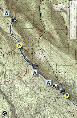
Eagle Rock has some of the best vistas in the Great North Mountain range.
The Tuscarora Trail was re-routed in 2014 to include the Eagle Rock
Trail, and now this spectacular hike can be done as either a 7.2 mile
out-and-back from US48/55, or as a family friendly 2.1 mile hike from
Dry Gap VA609. The longer 7.2 mile version also includes a rolling ridge walk with views of Paddy Gap as well as the gap between Paddy Mountain and Short Mountain.
The Eagle Rock Trail and overlook have never received the high traffic
found on similar hikes such as Big Schloss just to the south.
The Eagle Rock Trail and a portion of the Tuscarora Trail that was re-routed in 2014 pass through the private property of the Capon Springs Hunt Club. Please respect private property, remain on the trail, and practice Leave No Trace hiking etiquette.
- Mile 0.0 - From the parking area along 48/55 carefully cross to the north side of the road. Vehicles crest the ridge here at high speed, so use extreme caution crossing 48/55. In 200 yards arrive at a Y intersection with an old forestry road on the left. Stay right on the blue blazed Tuscarora Trail as it continues to climb the ridge. This section of the Tuscarora Trail from 48/55 to Dry Gap straddles the border of Virginia and West Virginia.
- Mile 0.25 - Arrive at the ridge with a beautiful view to the south of Paddy Mountain and Little Sluice Mountain. The ridge becomes narrow at this point.
- Mile 0.61 - Pass a campsite on the right that has views through the trees of the gap between Short Mountain and Paddy Mountain. There is no water source here, so if you decide to camp you will have to carry it in. From this point the communications tower service road will become more prominent on the left.
- Mile 0.77 - Pass a communications relay tower on the left. The Tuscarora Trail continues on the right side of the ridge.
- Mile 1.40 - Pass a second larger communications tower on the left. This tower is also a cellular station, so you should have excellent mobile coverage for those serviced by this provider. 30 yards past the tower is a power line clear cut that has a good view of the gap between Short Mountain and Paddy Mountain. The blue blazed trail now descends to a saddle on the ridge.
- Mile 1.79 - Arrive at the intersection of the orange blazed connector trail to the Hawk Recreation Area. The orange blazed trail was previously part of the blue blazed Tuscarora Trail before the Tuscarora Trail was re-routed in 2014. Stay straight on the blue blazed Tuscarora Trail as it the leaves George Washington National Forest property on the west side of the ridge. The right side of the trail is private property owned by the Capon Springs Hunt Club. Please respect private property and remain on the trail. After passing another knoll the blue blazed trail descends to the parking area at Dry Gap and VA690/Capon Springs Grade Rd.
- Mile 2.58 - Cross VA609/Capon Springs Grade Rd, then follow the blue blazed Eagle Rock/Tuscarora Trail as it climbs north towards the saddle between Great North Mountain and Spring Mountain. The trail becomes wider here.
- Mile 3.08 - At the saddle and split in the trail stay right, remain on the blue blazed trail which proceeds more steeply uphill. Just before arriving at the ridge pass through a section of Mountain Laurel.
- Mile 3.55 - Arrive at the ridge where the trail turns left. Stay on the trail for another 70 yards to the main Eagle Rock overlook.
- Mile 3.6 - The main Eagle Rock overlook has a concrete bench and is a beautiful spot for lunch. The panoramic view here is one of the best in the Great North Mountain area, with expansive views towards the Massanutten Range and Shenandoah National Park to the east, as well as the Great Great North Mountain massif to the south. This is the turn around for the hike. Retrace your route back to the parking area. From here the Tuscarora Trail continues past a weather station in 0.3 miles, then descends Great North Mountain and continues north.
- Mile 7.1 - Arrive back at US48/55.