Dutters Trail to Old Bark Loop at Loyalsock State Forest near Hillsgrove, Pennsylvania is a 4.5 mile hike that features several waterfalls and cascades and passes one overlook, Mary's View.
Trails:
This hike follows three named trails: Dutters Trail, Loyalsock Trail (yellow blazes), Old Bark Trail.
Parking:
Parking for this hike is on Dry Run Road and can be accessed via Route 87 (nears Hillsgrove). This road does not have winter maintenance and depending on conditions, may not be accessible at times during the winter. There is a small pull off just past Dry Run Falls at the Dutters Trailhead (41.43005, -76.66968), but for this hike I parked at the larger pull-off at Dry Run Falls. An alternate parking and starting point for this loop would be further up Dry Run Road where the Loyalsock Trail crosses the road (41.43815, -76.65450). There is a large pull-off at this point as well.
Hike:
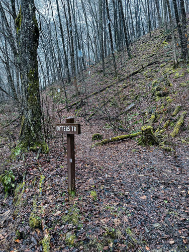
Starting counter-clockwise, there is a trailhead sign for Dutters Trail which is an old logging grade that follows Dutters Run towards the Loyalsock Trail, but the trail stays above the run.
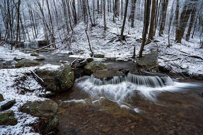
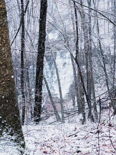
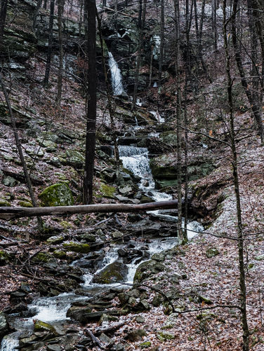
Dutters Run Waterfalls
Dutters Run has a couple beautiful waterfalls and scenic cascades, these can be seen from the trail, but to view them better you could drop down to the run or alternatively hike off-trail directly up the run to Loyalsock Trail.
At about .9 of a mile, the trail intersects with the Loyalsock Trail which descends slightly by a campsite and to Dutters Run. The trail then follows Dutters Run back down with several water crossings for roughly the next 1/2 mile. Expect to get wet feet!
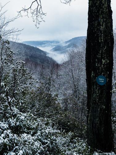
Mary's View - Mile 1.85
The Loyalsock Trail then meanders through the forest and passes Mary's View at about 1.85 and continues and crosses Dry Run Road at about 2.4 miles.
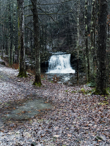
The Loyalsock Trail will meet up with Old Bark Trail at about 3.3 miles. Taking this trail will lead back to Dry Run Road and starts by traversing about .2 of a mile through a marshy area and connects with a wide old grade the rest of the way to the road. Near the bottom of Old Bark Trail, you can venture off the trail towards the run to see a waterfall when there is enough flow. The trail comes out at the road just below Dry Run Falls with the falls and parking area in view.
Camping & Backpacking:
This trail passes by a couple camp spots while on the Loyalsock Trail. Note that backpacking and camping is allowed within state forest rules and regulations.
Trails:
This hike follows three named trails: Dutters Trail, Loyalsock Trail (yellow blazes), Old Bark Trail.
Parking:
Parking for this hike is on Dry Run Road and can be accessed via Route 87 (nears Hillsgrove). This road does not have winter maintenance and depending on conditions, may not be accessible at times during the winter. There is a small pull off just past Dry Run Falls at the Dutters Trailhead (41.43005, -76.66968), but for this hike I parked at the larger pull-off at Dry Run Falls. An alternate parking and starting point for this loop would be further up Dry Run Road where the Loyalsock Trail crosses the road (41.43815, -76.65450). There is a large pull-off at this point as well.
Hike:
Starting counter-clockwise, there is a trailhead sign for Dutters Trail which is an old logging grade that follows Dutters Run towards the Loyalsock Trail, but the trail stays above the run.
Dutters Run Waterfalls
Dutters Run has a couple beautiful waterfalls and scenic cascades, these can be seen from the trail, but to view them better you could drop down to the run or alternatively hike off-trail directly up the run to Loyalsock Trail.
At about .9 of a mile, the trail intersects with the Loyalsock Trail which descends slightly by a campsite and to Dutters Run. The trail then follows Dutters Run back down with several water crossings for roughly the next 1/2 mile. Expect to get wet feet!
Mary's View - Mile 1.85
The Loyalsock Trail then meanders through the forest and passes Mary's View at about 1.85 and continues and crosses Dry Run Road at about 2.4 miles.
The Loyalsock Trail will meet up with Old Bark Trail at about 3.3 miles. Taking this trail will lead back to Dry Run Road and starts by traversing about .2 of a mile through a marshy area and connects with a wide old grade the rest of the way to the road. Near the bottom of Old Bark Trail, you can venture off the trail towards the run to see a waterfall when there is enough flow. The trail comes out at the road just below Dry Run Falls with the falls and parking area in view.
Camping & Backpacking:
This trail passes by a couple camp spots while on the Loyalsock Trail. Note that backpacking and camping is allowed within state forest rules and regulations.