The Dutchman Falls hike at Loyalsock State Forest near Laporte, Pennsylvania is a moderate 0.6-mile out-and-back trail that leads to the 25 to 30-foot tall waterfall named Dutchman Falls.
Trails
This hike follows two named trails: Loyalsock Trail (yellow blazes), Dutchman Falls Trail (blue blazes).
Hike Description
The trail begins at the main eastern parking lot for the Loyalsock Trail located off of PA-220. The trailhead can be found on the north side of the parking lot. The hike begins by heading downhill with a moderate to semi-steep grade while following the yellow blazes of the Loyalsock Trail as it winds its way down toward the first trail junction.
At the first junction, take a right-hand turn, heading east - following the sign that says "Dutchman Falls". About 50-feet down the trail, hikers will reach yet another "Dutchman Falls" sign where the blue blazes of the Dutchman Falls Trail begin. Take a left-hand turn here and follow the blue blazes downhill to reach the first waterfall in the creek - Upper Dutchman Falls, which is free fall waterfall at about 5 to 6-feet tall.
To reach the base of Dutchman Falls, the 25 to 30-foot waterfall, hikers must scale a fairly-steep hillside from Upper Dutchman Falls down to the lower pool. The area adjacent to Dutchman Falls can be a bit tricky because of the steep terrain, especially during the winter, and may require a scramble on the way back.
Dutchman Falls - Mile 0.3
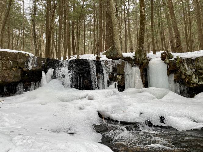
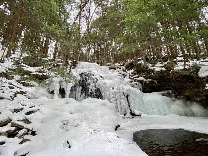
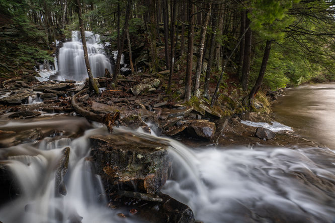
Hikers will finally reach the base of Dutchman Falls at mile 0.3. Dutchman Falls cascades down Dutchman Run creek at approximately 25 to 30-feet tall. During the winter, the waterfall can be found covered in massive chunks of ice while the creek continues to flow behind its ice wall.
Hiking Out
As stated earlier, the hike back up the hillside adjacent to Dutchman Falls may require a scramble (using your hands) to make your way back up.
Parking
Hikers will find parking at a large lot located at the coordinates provided at the Loyalsock Trailhead. The lot is large enough to fit about two-dozen vehicles.
Restrooms
There are restrooms at the parking lot / trailhead.
Pets
Dogs are allowed if leashed and their waste should be carried out by the hiker.
Warnings
Steep terrain: reaching Dutchman Falls follows some steep terrain. It's recommended to use proper hiking footwear and trekking poles, if necessary. During the winter, this hike is likely impossible to do without ice spikes or hiking crampons due to the slick, icy, and steep terrain leading downhill.
Blaze Color
This hike follows yellow blazes until the hiker reaches the first trail junction with the "Dutchman Falls" sign. Thereafter, hikers will follow blue blazes of the Dutchman Falls Trail that leads further downhill to reach the waterfall, hence the blue blazes.
Trails
This hike follows two named trails: Loyalsock Trail (yellow blazes), Dutchman Falls Trail (blue blazes).
Hike Description
The trail begins at the main eastern parking lot for the Loyalsock Trail located off of PA-220. The trailhead can be found on the north side of the parking lot. The hike begins by heading downhill with a moderate to semi-steep grade while following the yellow blazes of the Loyalsock Trail as it winds its way down toward the first trail junction.
At the first junction, take a right-hand turn, heading east - following the sign that says "Dutchman Falls". About 50-feet down the trail, hikers will reach yet another "Dutchman Falls" sign where the blue blazes of the Dutchman Falls Trail begin. Take a left-hand turn here and follow the blue blazes downhill to reach the first waterfall in the creek - Upper Dutchman Falls, which is free fall waterfall at about 5 to 6-feet tall.
To reach the base of Dutchman Falls, the 25 to 30-foot waterfall, hikers must scale a fairly-steep hillside from Upper Dutchman Falls down to the lower pool. The area adjacent to Dutchman Falls can be a bit tricky because of the steep terrain, especially during the winter, and may require a scramble on the way back.
Dutchman Falls - Mile 0.3
Hikers will finally reach the base of Dutchman Falls at mile 0.3. Dutchman Falls cascades down Dutchman Run creek at approximately 25 to 30-feet tall. During the winter, the waterfall can be found covered in massive chunks of ice while the creek continues to flow behind its ice wall.
Hiking Out
As stated earlier, the hike back up the hillside adjacent to Dutchman Falls may require a scramble (using your hands) to make your way back up.
Parking
Hikers will find parking at a large lot located at the coordinates provided at the Loyalsock Trailhead. The lot is large enough to fit about two-dozen vehicles.
Restrooms
There are restrooms at the parking lot / trailhead.
Pets
Dogs are allowed if leashed and their waste should be carried out by the hiker.
Warnings
Steep terrain: reaching Dutchman Falls follows some steep terrain. It's recommended to use proper hiking footwear and trekking poles, if necessary. During the winter, this hike is likely impossible to do without ice spikes or hiking crampons due to the slick, icy, and steep terrain leading downhill.
Blaze Color
This hike follows yellow blazes until the hiker reaches the first trail junction with the "Dutchman Falls" sign. Thereafter, hikers will follow blue blazes of the Dutchman Falls Trail that leads further downhill to reach the waterfall, hence the blue blazes.