This is a great hike for families with young kids due to its relative lack of elevation change and would be easy to push a stroller on. There were also many people walking their dogs. This hike should be considered wheelchair accessible with just a little help in 1 or 2 short areas.
Notes:
- The drive to the Visitor Center parking area will lead you past a county sewage treatment plant and a large Dominion Virginia Power Plant. You will even see the Power Plant on some parts of the trail but do not let this Industrail “beast” deter you from visiting and seeing the “beauty” of this area.
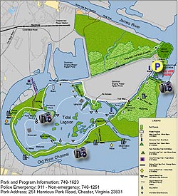
- There are many spur trails (usually out and back) to observation points throughout this hike, we did many of them. The loop back to the Visitor Center is 4.4 miles, doing most of the spur trails will push the mileage close to 6 miles. It was on the very first one where we saw a bald-eagle. To your right on the blue blazed trail beyond the fence is the Dominion Power Flyash Pond. Be sure to keep your eyes open on this hike for all sorts of wildlife. In fact, don’t forget to pack binoculars.
- There have been reports of Vultures at Dutch Gap landing on cars and causing damage. I checked on this at the Visitor Center and it is true but it is at the Dutch Gap Boat Landing about 1 mile from the Visitor Center and has not happened at the Visitor Center parking area.
We started the hike behind the DGCA Visitor Center on the Blue-blazed trail. In 0.3 miles you will come to the Sycamore Spur trail on the left and is only 150 yards to an observation area and small floating fishing pier (there are quite a few of these piers throughout the trail) . Return to the Blue-blazed trail taking a left continuing for 0.3 miles until the Twin Rock Spur trail on the left with a short walk to an observation area/bench.
Continue on the Blue-blazed trail for 0.1 miles until the intersection of the White-blazed main loop. Stay straight at the intersection doing the main loop counter-clockwise. Ignore the next intersection which is just a shortcut to the other side of the main loop. The trail will bear hard to the left in 0.1 miles leading you to the intersection of the Horse Tail Loop in 0.2 miles. We only went to the observation point on this loop and returned back to the main white loop trail. (You could stay on the Teal-blazed Horse Tail Loop and it would meet up again with the main loop). Return to the main loop and in about 60 yards is one of the few sections that someone in a wheelchair might need a hand to go up a short hill. It is this portion of the trail where you will see the power plant straight ahead, but not for long. Just after the hill on the left you will see the Horse Tail Loop meet the trail and soon after that the trail will bear to the left. From this point to the next intersection, Peninsula Point, is 0.6 miles. Peninsula Point has picnic tables and boats for rent in season (check at visitor center prior to the hike). If bypassing Peninsula Point, bear to the right or if returning from Peninsula Point bear to the left and continue on the main loop.
To the Oxbow Point Intersection is about 0.4 miles, there is a nice bench/observation area at the end of this spur trail. On the next portion of the trail we saw a couple of sunken barges inside the lagoon. This section of the trail seemed to be the longest as it is almost 1.3 miles until the Dog Leg Intersection. It was on this not very wide part of the trail that we saw a buck and 7 does. The Dog Leg trail is no longer a Dog Leg trail as it just ends as you come to the Old River Channel of the James. We surprised some duck hunters at this point. The trail that was supposed to be to the left and parallel to the Channel is overgrown and I could not find it.
Back on the main loop it is only 0.1 miles to the bridge from the Dog Leg Intersection. This is the other section of the trail where someone in a wheelchair may need a hand as the ramp up to the bridge is a little steep. This channel is the main supply of water from the James River to the Lagoon. In another 0.2 miles you will come to an Intersection on the left and mentioned earlier as a shortcut, stay straight on the main loop and go 0.1 miles to an observation blind overlooking a marsh. This is to view nesting herons in the Spring time. In about 150 yards you will come to the end of the main loop trail, bear to the right and rejoin the blue blazed trail to return to the parking area in 0.6 miles.