Loading...

📌 Love our trails? Set MyHikes as your preferred Google source. Add Now ⛰️

Dunlop Brook Falls

Exploring Dunlop Brook Falls in Pelham, Massachusetts is an easy 0.4-mile out-and-back hike that leads to the multi-tiered 25-foot tall waterfall, Dunlop Brook Falls.

Hiking to Dunlop Brook Falls

This very short and easy hike begins along the dead-end road, Cook Road, in Pelham. No real designated parking areas are available along Cook Road, however, about half-way down the road is enough space for one or two vehicles to pull off of the road to allow other vehicles to pass-by. Park here and hike north along the road.

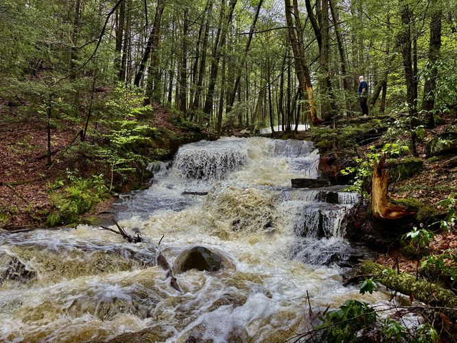
Just before the bridge, visitors will find signs posted by the Pelham Conservation Commission with an adjacent foot path that leads into the forest. Hike up the trail as it passes through a hemlock forest to reach Dunlop Brook. Once you're at the brook, you'll find Lower Dunlop Brook Falls below your feet with bedrock covered in mosses and ferns. Here, the hiking becomes a bit more difficult as the path leads up and down the steep hillside next to Dunlop Brook where you may have to do some light scrambling to get around. Watch your step as you traverse the banks of the brook as there are some steep sections above the water.

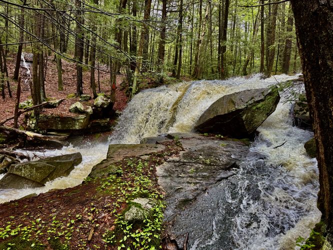
As noted, hikers will find the ~12-foot tall Lower Dunlop Brook Falls within seconds of hopping off of Cook Road. You can choose to hike to the base of the waterfall to find the best view. Next, if you head upstream, you'll find Middle Dunlop Brook Falls cascading down the bedrock at about 6-feet tall, surrounded by large boulders.

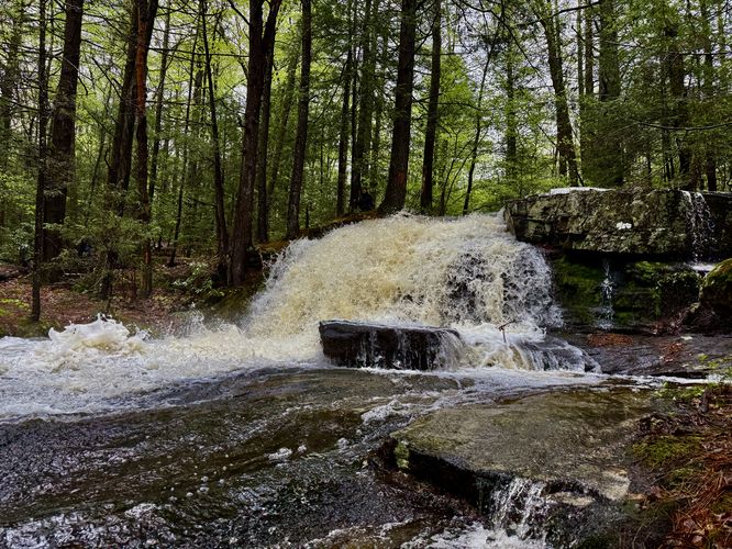
After exploring middle falls, head uphill just a bit further to find Upper Dunlop Brook Falls as it cascades over a bedrock ledge at about 7-feet tall. And while you may think the scenery is over, there's a small ~2-foot cascade located above upper falls you can explore too.

Once you're done exploring the waterfall, the hike back to parking heads back to Cook Road and down the street to reach the small turnout area.

Parking

Visitors will find a very small parking turnout along the east side of Cook Road in Pelham, MA. There's enough room for one or two vehicles (max) to park without blocking road traffic. Do not drive to the end of the road as it's a private residence! Simply do a multi-point turn to leave Cook Road. Do not crowd the road or attempt to park if there's no room. Do no disturb the private land owners at the end of the road.

Private Property

Important note: Cook Road and the land to the east is public, but the very-end of the road (across the bridge over Dunlop Brook) is private land. Please respect land owners and stay on the public road or the conservation commission's land, which is located on either side of Dunlop Brook. The land is maintained by the town of Pelham and the Pelham Conservation Commission as of 2025.

Pets

Dogs are allowed only if leashed and cleaned up after.
Explore 207 trails near Pelham, MA

Know Before You Go

  • Dunlop Brook Falls in Pelham, MA, offers a short, easy 0.4-mile hike to a multi-tiered 25-foot waterfall.
  • Parking is limited to a small turnout on Cook Road, and visitors should respect private property at the end of the road.
  • The trail follows Dunlop Brook, leading to Lower, Middle, and Upper Dunlop Brook Falls, with some light scrambling required along steep banks.
Interactive topographic map for Dunlop Brook Falls located in Pelham, MA. Click the "View Map" button to load GPS coordinates and trail markers.
Get directions
Distance
0.4 mi
Difficulty
Easy
Type
Out-and-Back
Est. Time
12 min
Elev. Gain
56'
Rating
4.0
Added
May 10, 2025
Updated
June 11, 2025

Weather Forecast

Tonight
Low 60°F
Slight Chance Showers And Thunderstorms then Showers And Thunderstorms Likely
Monday
High 79°F
Slight Chance Rain Showers then Mostly Sunny
Monday Night
Low 52°F
Mostly Clear
Tuesday
High 81°F
Sunny
Tuesday Night
Low 54°F
Mostly Clear
Wednesday
High 83°F
Mostly Sunny then Slight Chance Rain Showers
Wednesday Night
Low 56°F
Slight Chance Rain Showers
Thursday
High 83°F
Rain Showers Likely
Thursday Night
Low 61°F
Showers And Thunderstorms Likely
Juneteenth
High 84°F
Slight Chance Rain Showers
Friday Night
Low 57°F
Slight Chance Rain Showers then Partly Cloudy
Saturday
High 82°F
Sunny
Saturday Night
Low 57°F
Mostly Clear
Sunday
High 83°F
Sunny

Don't let Google decide who you trust.

Loading...
Total Change
73 ft.
22 m
Ascent
56 ft.
17 m
Descent
57 ft.
17 m
Loading...

Download the GPX Data for Offline Use

Supporters get exclusive access to download trail routes to the MyHikes app for offline use. Stay prepared on your adventure, even without an internet connection! Become a Supporter today to unlock this feature and hike with confidence.

Download Dunlop Brook Falls GPX Data to the MyHikes Mobile App

Features

Dogs
Waterfalls

Points of interest

  1. Parking

    42.382724, -72.431694
  2. Main Trailhead

    42.382791, -72.431702
  3. Lower Dunlop Brook Falls

    42.384433, -72.431136
    Lower Dunlop Brook Falls
  4. Middle Dunlop Brook Falls

    42.3843, -72.430831
    Middle Dunlop Brook Falls

Safety information

For your own safety: plan ahead, let someone know where you'll be, and hike at your own risk.

Hazards

Poison Ivy or Poison Oak
Rockfalls, Ledges, or Scrambles

Availability

All seasons

Surface type

Dirt

Trip Reports (Reviews)

Rated 4.0 out of 5 based on 1 rating.

Ready to help fellow hikers? Add a trip report to share your experience!

No community routes found. To add your own hike as a Community Route for this Trail guide, leave a Trip Report with an attached GPX file.

You may also like

Colorado's Million Dollar Highway - Plan a day's drive adventure along the iconic Million Dollar Highway in Colorado. Explore the best short trails, roadside stops, waterfalls, vistas, ghost towns, and hot springs within a ~6 hour road trip.
Explore

Colorado's Million Dollar Highway

Plan a day's drive adventure along the iconic Million Dollar Highway in Colorado. Explore the best short trails, roadside stops, waterfalls, vistas, ghost towns, and hot springs within a ~6 hour road trip.

Read
Glacier's Going-to-the-Sun Road - Discover the breathtaking beauty of Glacier National Park along the iconic Going-to-the-Sun Road. From stunning roadside stops to picturesque waterfalls and vistas, this engineering marvel offers endless opportunities for exploration.
Explore

Glacier's Going-to-the-Sun Road

Discover the breathtaking beauty of Glacier National Park along the iconic Going-to-the-Sun Road. From stunning roadside stops to picturesque waterfalls and vistas, this engineering marvel offers endless opportunities for exploration.

Read
🍪 We use cookies to learn about site usage and to serve map tiles. You may block cookies manually in the browser. By continuing you agree. Learn more