The Dune Shacks Trail & Shark Henge at Cape Cod National Seashore in Provincetown, Massachusetts is a difficult 2.8-mile out-and-back hike that features private remote dune shacks and an abandoned concrete building with graffiti known as Shark Henge.
Shark Henge Name
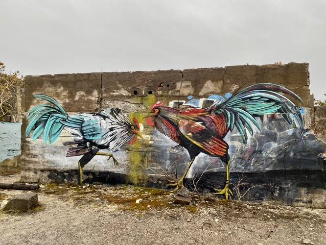
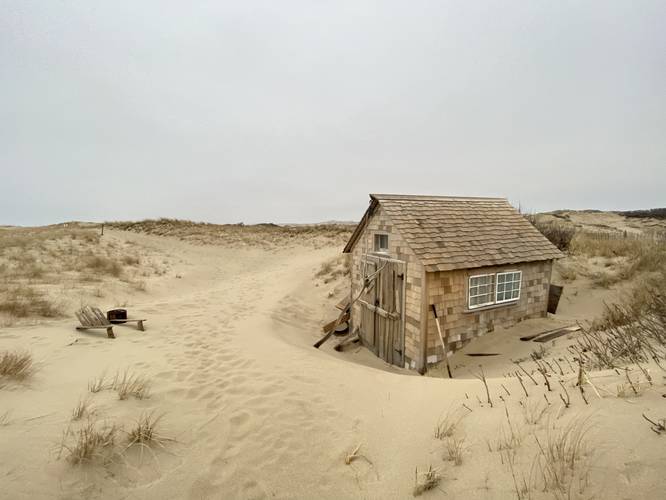
Note that "Shark Henge" was named after the large shark graffiti that once adorned the walls of the abandoned building located on the east part of the loop; however, as of early April, 2023, the shark has been replaced with two roosters. "Rooster Henge" may not be a suitable name, but the shark is no-more.
Hike Description
This hike begins at the main trailhead located near the coordinates provided for parking. The Dune Shacks Trail has critical information at the small kiosk and signage before you get onto the dunes - please read and understand that the shacks have private owners and the national seashore allows the public to walk these trails assuming you give the owners privacy. Please read and understand the warnings before going out too.
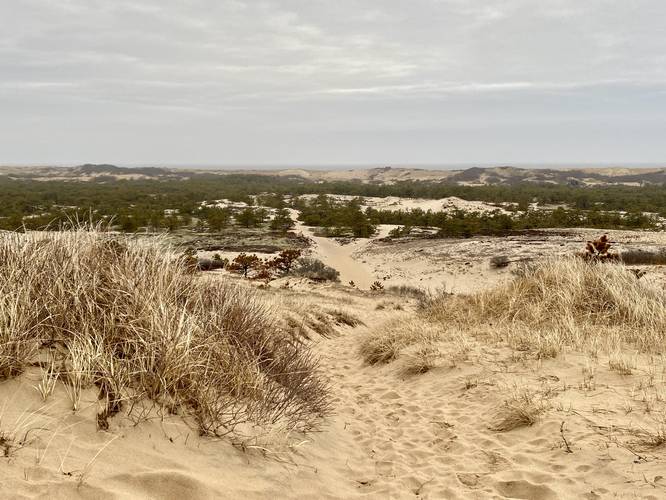
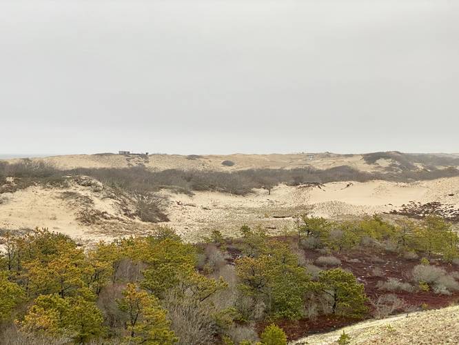
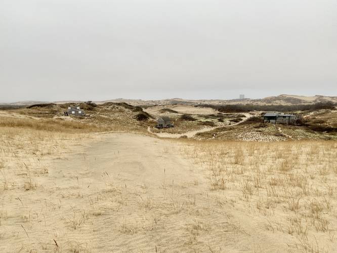
The trail begins by ascending a dune, bringing hikers above the local treeline of where trees stop growing on the dunes. Immediately after cresting the first dune, you'll hike down about 30-feet or more. Off to the side is a small oasis of dune forest - something I did not expect to see growing in the dunes. Next up is a ~60-foot dune climb, which is not easy. Once atop the second dune, it'll undulate a bit before providing hikers with a view of the dune forest below them and more dunes off to the distance - with dune shacks sitting atop the ridge. Hike down once more to reach the flat sandy forest floor. Hike north along the main path - or in this case slightly adjacent to it - to reach a large trail junction.
Optional Left-Hand Turn - Mile 0.7 to 1.6
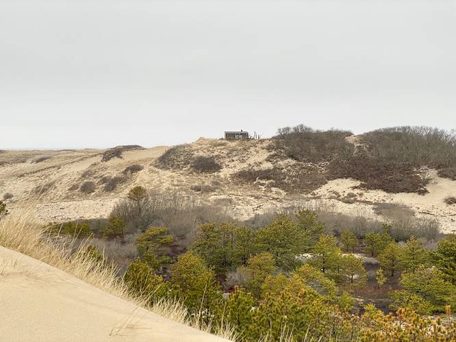
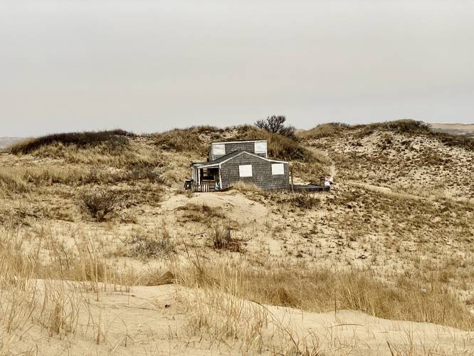
At mile 0.7, if you wish to get an interesting view, you can hike west along the trail. Hike up the first dune and look northeast to find several dune shacks on the ridge of the dune that separates the Atlantic Ocean from the dune forest. Note that the mileage listed includes this left-hand turn offshoot.
Once back at the main junction, or if you skip the left-hand optional walk, the main loop to view dune shacks begins. Hikers will head up the dune and take a right-hand turn, skipping the sign directions for "beach" and instead follow the "no beach access" signs, around mile 1.3.
Dune Shacks - Mile 1.4 to 1.6
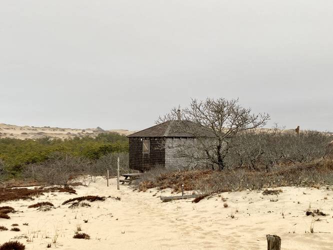
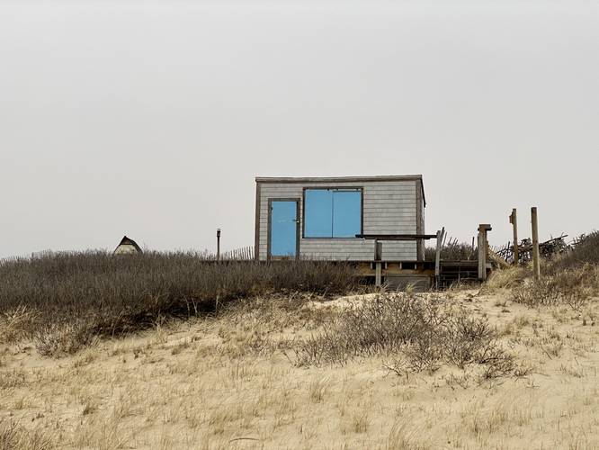
At mile 1.4, hikers will pass a dune shack located 50-feet or so off-trail. Just beyond this is another private dune shack where the trail passes directly in-front of (sorry owner); however, this scenic dune-swept shack is worth walking by during off seasons when no one is around. The trail will head east and then take a bend to head down the dune once more, passing 3 dune shacks along the way - one located 200-feet off-trail and two located about 50-feet off-trail. Again, please do not disturb the shacks or their residents, simply walk past to enjoy them.
"Shark Henge" - Mile 1.75
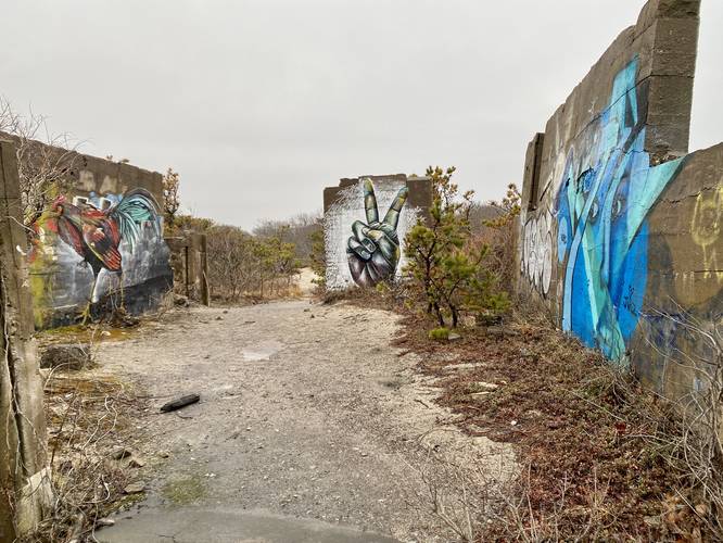
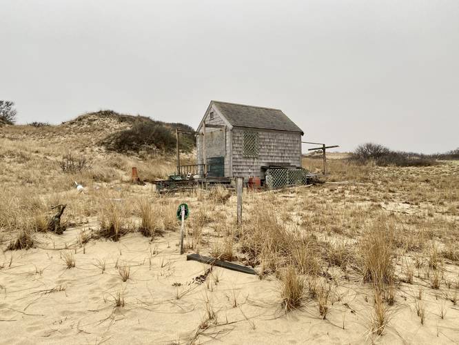
At mile 1.75 hikers will reach a junction in the trail where an abandoned building sits with several different graffiti tags. As of April 1, 2023 the shark that used to decorate the bleak walls of this abandoned building was replaced with two roosters. According to some maps, this abandoned building was the Peaked Hill Bars Life-Saving Station; however, this appears to be wrong as described on this official US Life-Saving Station page where it notes that the Peaked Hill Bars Life-Saving Station was sold to Eugene O'Neill in 1919 but fell into the Ocean off of an eroded bluff in 1931.
Dune Shack - Mile 1.9
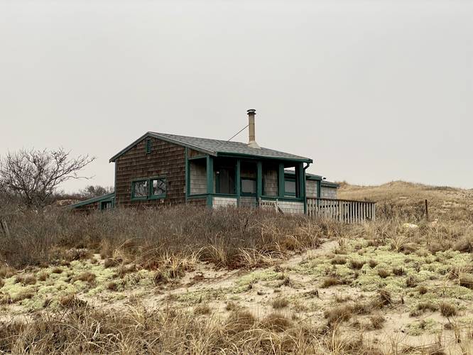
After visiting "Shark Henge" (Rooster Henge?), hikers will head west along the secondary trail where they'll find another dune shack located around mile 1.9, located off-trail.
After checking out the last dune shack, hikers will reach the main trail junction once more where you'll hike out along the same route. The hike back up the dunes is not easy, so take your time.
Difficulty
For the average hiker, this trail should be considered "Hard" or difficult, hence the difficulty rating. Mostly due to the Warnings below - please read before heading out.
Parking
Hikers will find parking at the coordinates provided along MA-6. The trailhead itself has 3 parking spaces but there are large parking turnouts along Route 6.
Pets
Dogs are allowed only if leashed and cleaned up after. This area is very remote and has no trash cans - please clean up after your dog and carry out.
History
This unmarked trail leads through the Dune Shacks of Peaked Hill Bars Historic District and over to the Atlantic Ocean. The earliest shacks were built as temporary dwellings for the families of surfmen who were stationed at the Peaked Hill Bars Life-Saving Station. Some shacks were built by the fishing community to stow gear or provide shelter. Noted American playwright Eugene O'Neill spent time in a shack here in 1919 and later took up residence in the life-saving station after it was decommissioned by the U.S. Coast Guard. Over the decades, artists, writers, and those looking to experience a remote and rustic dune life have been inspired by this landscape and its solitude. Today the shacks are still occupied by private citizens and some are owned by local non-profits.
Warning
Sand hiking / steep dunes: This trail follows sand the entire length, except for about 100-feet from parking to the main trail. This means that for every step of elevation gain, you immediately lose elevation gain. On the 60-foot dune climb, that 60-feet of elevation gain is at about 90-feet considering you lose about 50% of each step in sand. For the total elevation gain (227-feet, assume this is more like 400-feet). This might be one of the hardest hikes on Cape Cod due to the elevation change and sand hiking. If you hike further than this route, it obviously becomes harder.
Lack of cell service: Cell service on this trail (Verizon) is spotty at best and only available at the tops of the dunes. Due to this, downloading offline maps can help you navigate this terrain a lot easier.
No water: This trail has virtually no reliable or potable water sources. I would not attempt to filter any bog water found in the dune forest, so pack in everything you need - at least 2 liters of water especially during warm months.
Sun exposure: Once you're on the trail, you're exposed to the sun almost the entire time you're out hiking the Dune Shacks Trail. Wear sun screen and protect your skin as best you can. Bring extra water during warm or hot months.
Private Shacks: Most of these shacks are private, thus the owners aren't expecting hiking company; however, there's nothing they can do from the public walking nearby. Please do not disturb any occupants of the dune shacks and stay away from them unless the trail passes through. Note that this path passes in front of one private shack, so be mindful - if you're visiting during off-seasons, then no one will be around. During peak seasons, please give the private shack owners their space.
Wild animals: On this hike April 1, 2023, I was the only person on the trail that day due to the excessive rain; however, I ran into a coyote in the early morning as it ran across the trail in front of me. Nothing to be afraid of, but hikers should note that wild animals are out in these dunes looking for food. Do not feed the wild animals.
Stay on-trail: Stay on trails at all times and do not step on the plants to prevent additional erosion.
Shark Henge Name
Note that "Shark Henge" was named after the large shark graffiti that once adorned the walls of the abandoned building located on the east part of the loop; however, as of early April, 2023, the shark has been replaced with two roosters. "Rooster Henge" may not be a suitable name, but the shark is no-more.
Hike Description
This hike begins at the main trailhead located near the coordinates provided for parking. The Dune Shacks Trail has critical information at the small kiosk and signage before you get onto the dunes - please read and understand that the shacks have private owners and the national seashore allows the public to walk these trails assuming you give the owners privacy. Please read and understand the warnings before going out too.
The trail begins by ascending a dune, bringing hikers above the local treeline of where trees stop growing on the dunes. Immediately after cresting the first dune, you'll hike down about 30-feet or more. Off to the side is a small oasis of dune forest - something I did not expect to see growing in the dunes. Next up is a ~60-foot dune climb, which is not easy. Once atop the second dune, it'll undulate a bit before providing hikers with a view of the dune forest below them and more dunes off to the distance - with dune shacks sitting atop the ridge. Hike down once more to reach the flat sandy forest floor. Hike north along the main path - or in this case slightly adjacent to it - to reach a large trail junction.
Optional Left-Hand Turn - Mile 0.7 to 1.6
At mile 0.7, if you wish to get an interesting view, you can hike west along the trail. Hike up the first dune and look northeast to find several dune shacks on the ridge of the dune that separates the Atlantic Ocean from the dune forest. Note that the mileage listed includes this left-hand turn offshoot.
Once back at the main junction, or if you skip the left-hand optional walk, the main loop to view dune shacks begins. Hikers will head up the dune and take a right-hand turn, skipping the sign directions for "beach" and instead follow the "no beach access" signs, around mile 1.3.
Dune Shacks - Mile 1.4 to 1.6
At mile 1.4, hikers will pass a dune shack located 50-feet or so off-trail. Just beyond this is another private dune shack where the trail passes directly in-front of (sorry owner); however, this scenic dune-swept shack is worth walking by during off seasons when no one is around. The trail will head east and then take a bend to head down the dune once more, passing 3 dune shacks along the way - one located 200-feet off-trail and two located about 50-feet off-trail. Again, please do not disturb the shacks or their residents, simply walk past to enjoy them.
"Shark Henge" - Mile 1.75
At mile 1.75 hikers will reach a junction in the trail where an abandoned building sits with several different graffiti tags. As of April 1, 2023 the shark that used to decorate the bleak walls of this abandoned building was replaced with two roosters. According to some maps, this abandoned building was the Peaked Hill Bars Life-Saving Station; however, this appears to be wrong as described on this official US Life-Saving Station page where it notes that the Peaked Hill Bars Life-Saving Station was sold to Eugene O'Neill in 1919 but fell into the Ocean off of an eroded bluff in 1931.
Dune Shack - Mile 1.9
After visiting "Shark Henge" (Rooster Henge?), hikers will head west along the secondary trail where they'll find another dune shack located around mile 1.9, located off-trail.
After checking out the last dune shack, hikers will reach the main trail junction once more where you'll hike out along the same route. The hike back up the dunes is not easy, so take your time.
Difficulty
For the average hiker, this trail should be considered "Hard" or difficult, hence the difficulty rating. Mostly due to the Warnings below - please read before heading out.
Parking
Hikers will find parking at the coordinates provided along MA-6. The trailhead itself has 3 parking spaces but there are large parking turnouts along Route 6.
Pets
Dogs are allowed only if leashed and cleaned up after. This area is very remote and has no trash cans - please clean up after your dog and carry out.
History
This unmarked trail leads through the Dune Shacks of Peaked Hill Bars Historic District and over to the Atlantic Ocean. The earliest shacks were built as temporary dwellings for the families of surfmen who were stationed at the Peaked Hill Bars Life-Saving Station. Some shacks were built by the fishing community to stow gear or provide shelter. Noted American playwright Eugene O'Neill spent time in a shack here in 1919 and later took up residence in the life-saving station after it was decommissioned by the U.S. Coast Guard. Over the decades, artists, writers, and those looking to experience a remote and rustic dune life have been inspired by this landscape and its solitude. Today the shacks are still occupied by private citizens and some are owned by local non-profits.
Warning
Sand hiking / steep dunes: This trail follows sand the entire length, except for about 100-feet from parking to the main trail. This means that for every step of elevation gain, you immediately lose elevation gain. On the 60-foot dune climb, that 60-feet of elevation gain is at about 90-feet considering you lose about 50% of each step in sand. For the total elevation gain (227-feet, assume this is more like 400-feet). This might be one of the hardest hikes on Cape Cod due to the elevation change and sand hiking. If you hike further than this route, it obviously becomes harder.
Lack of cell service: Cell service on this trail (Verizon) is spotty at best and only available at the tops of the dunes. Due to this, downloading offline maps can help you navigate this terrain a lot easier.
No water: This trail has virtually no reliable or potable water sources. I would not attempt to filter any bog water found in the dune forest, so pack in everything you need - at least 2 liters of water especially during warm months.
Sun exposure: Once you're on the trail, you're exposed to the sun almost the entire time you're out hiking the Dune Shacks Trail. Wear sun screen and protect your skin as best you can. Bring extra water during warm or hot months.
Private Shacks: Most of these shacks are private, thus the owners aren't expecting hiking company; however, there's nothing they can do from the public walking nearby. Please do not disturb any occupants of the dune shacks and stay away from them unless the trail passes through. Note that this path passes in front of one private shack, so be mindful - if you're visiting during off-seasons, then no one will be around. During peak seasons, please give the private shack owners their space.
Wild animals: On this hike April 1, 2023, I was the only person on the trail that day due to the excessive rain; however, I ran into a coyote in the early morning as it ran across the trail in front of me. Nothing to be afraid of, but hikers should note that wild animals are out in these dunes looking for food. Do not feed the wild animals.
Stay on-trail: Stay on trails at all times and do not step on the plants to prevent additional erosion.