Dry Run Falls at Loyalsock State Forest near Hillsgrove, Pennsylvania is an easy 0.1-mile out-and-back hike that leads to the scenic 13-foot tall waterfall, Dry Run Falls.
After exploring the base of the waterfall, you can head back uphill to check out the view from the top. This route leads along the creek's top-most bedrock to head out to the very top of Dry Run Falls with a view toward its pool below. During our visit in December 2024, we found spray from the waterfall had frozen to the rocks below, making for a scenic view of contrast from the top of the cascade.
Timber Rattlesnakes: This area is home to the Timber Rattlesnake which can be found roaming the forest between the end of April and October each year. Be on the lookout and give any rattler you find plenty of space.
Exploring Dry Run Falls
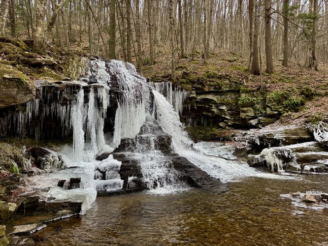
Visitors will find Dry Run Falls cascading down the creek, located right next to the parking area, along Dry Run Road. The waterfall can be enjoyed from various viewpoints, including a downstream view that requires just a couple dozen feet of walking (out-and-back). If you wish to view Dry Run Falls from the base of the waterfall, this short route will bring you there -- simply walk west to reach a downstream view of the waterfall, then locate the root-filled path that leads downhill. Here, you'll find a well-beaten path that leads close to the base of the waterfall, with a couple of spots to take-in the sights from downstream. Dry Run Falls cascades over a bedrock cliff within Dry Run Creek at about 13-feet tall and makes for a splendid sight with such an accessible waterfall.After exploring the base of the waterfall, you can head back uphill to check out the view from the top. This route leads along the creek's top-most bedrock to head out to the very top of Dry Run Falls with a view toward its pool below. During our visit in December 2024, we found spray from the waterfall had frozen to the rocks below, making for a scenic view of contrast from the top of the cascade.
Universal Access
Note that this trail is not tagged as universally accessible, but Dry Run Falls entirely visible from Dry Run Road, which means you do not necessarily need to leave your vehicle to enjoy this waterfall. For that reason, this waterfall should be considered universally-accessible, but the route and trail to reach the views is not.Parking
Visitors will find a small parking turnout located at the coordinates provided, along Dry Run Road. The turnout is large enough to fit less than a dozen vehicles as of December 2024. Note that Dry Run Road is not maintained during the Winter months and thus the road might be impassible or covered in snow and ice during cold months.Pets
Dogs are allowed if leashed and must be cleaned up after.Warning
Ledges: This route leads to the top of Dry Run Falls where you'll find rock ledges. During cold months, the rocks can be covered in a thin layer of ice. Watch your step and explore at your own risk.Timber Rattlesnakes: This area is home to the Timber Rattlesnake which can be found roaming the forest between the end of April and October each year. Be on the lookout and give any rattler you find plenty of space.