Loading...

WINTER SALE! 50% OFF Supporter Accounts — now through January 31st. Learn More.

Drummer Boy Park Trail

The Drummer Boy Park Trail at Drummer Boy Park in Brewster, Massachusetts is an easy 0.4-mile universal access loop trail that encompasses the park and features views of the Quivett Creek Marshes.

Walk Description
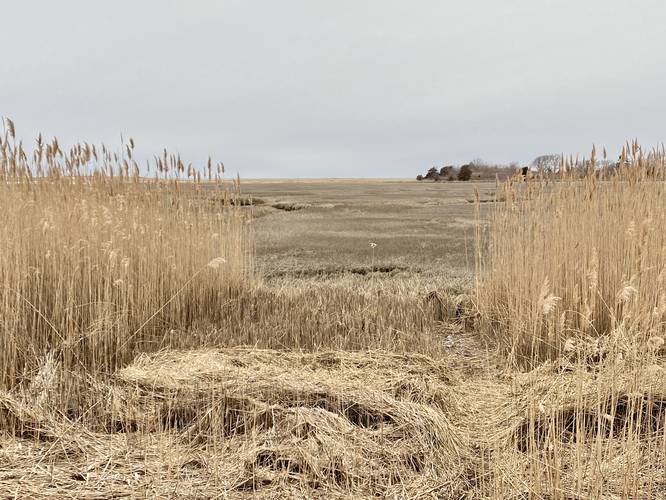
This is not a hike, but rather a short and easy walk along a paved trail. The trailhead can be found at the northeast corner of the large parking circle at Drummer Boy Park. At the north end of the trail is a short out-and-back spur that leads to a viewing point of the Quivett Creek saltwater marshes. Be sure to check out the Brewster Windmill Village before leaving.

Parking
Walkers can find a large parking turnout at the coordinates provided at Drummer Boy Park.

Pets
Dogs are allowed only if leashed and cleaned up after.
Explore 45 trails near Brewster, MA

Know Before You Go

  • Easy, paved 0.4-mile loop trail suitable for all abilities, located within Drummer Boy Park in Brewster, MA.
  • Features scenic views of the Quivett Creek marshes, accessible via a short out-and-back spur.
  • Dog-friendly (leashed and cleaned up after) with convenient parking and the Brewster Windmill Village nearby.
Interactive topographic map for Drummer Boy Park Trail located in Brewster, MA. Click the "View Map" button to load GPS coordinates and trail markers.
Get directions
Distance
0.3 mi
Difficulty
Easy
Type
Loop
Est. Time
9 min
Elev. Gain
27'
Rating
0.0
Added
April 04, 2023
Updated
April 04, 2023

Weather Forecast

Loading...
Total Change
27'
Ascent
27'
Descent
27'
Loading...

Download the GPX Data for Offline Use

Supporters get exclusive access to download trail routes to the MyHikes app for offline use. Stay prepared on your adventure, even without an internet connection! Become a Supporter today to unlock this feature and hike with confidence.

Download Drummer Boy Park Trail GPX Data to the MyHikes Mobile App

Features

Vista / Lookout Point
Dogs

Points of interest

  1. Parking

    41.752462, -70.119389
  2. Main Trailhead

    41.752583, -70.11926

Safety information

For your own safety: plan ahead, let someone know where you'll be, and hike at your own risk.

Availability

All seasons

Surface type

Universal Access

Trip Reports (Reviews)

Your opinion matters! Be the first to rate this trail.

Ready to help fellow hikers? Add a trip report to share your experience and provide valuable insights for other hikers!

No community routes found. To add your own hike as a Community Route for this Trail guide, leave a Trip Report with an attached GPX file.

Popular categories

Scenic mountain view representing vista trails
Vista trails
Scenic gorge of cascades representing waterfall trails
Waterfall hikes
Rugged mountain terrain representing summit trails
Summit trails
Scenic mountain view representing dog-friendly trails
Dog-friendly
Scenic campsite with a view representing camping trails
Camping trails
Appalachian Trail logo representing A.T. hikes
A.T. hikes

You May Also Like

Colorado's Million Dollar Highway - Plan a day's drive adventure along the iconic Million Dollar Highway in Colorado. Explore the best short trails, roadside stops, waterfalls, vistas, ghost towns, and hot springs within a ~6 hour road trip.
Explore

Colorado's Million Dollar Highway

Plan a day's drive adventure along the iconic Million Dollar Highway in Colorado. Explore the best short trails, roadside stops, waterfalls, vistas, ghost towns, and hot springs within a ~6 hour road trip.

Read
Glacier's Going-to-the-Sun Road - Discover the breathtaking beauty of Glacier National Park along the iconic Going-to-the-Sun Road. From stunning roadside stops to picturesque waterfalls and vistas, this engineering marvel offers endless opportunities for exploration.
Explore

Glacier's Going-to-the-Sun Road

Discover the breathtaking beauty of Glacier National Park along the iconic Going-to-the-Sun Road. From stunning roadside stops to picturesque waterfalls and vistas, this engineering marvel offers endless opportunities for exploration.

Read
🍪 We use cookies to learn about site usage and to serve map tiles. You may block cookies manually in the browser. By continuing you agree. Learn more