Double Run to Canyon Vista Loop at Worlds End State Park near Forksville, Pennsylvania is a moderate 3.7-mile loop hike that features views of the Loyalsock Canyon.
Worlds End State Park and the surrounding Loyalsock State Forest offers some great hiking and many options to create loop hikes. I hiked this hike after a fresh snowfall and picked the starting point that I knew would be accessible in winter conditions. The hike includes two vistas and some interesting rock formations.
Parking:
Park at the Double Run Nature Trailhead off of Route 154 within Worlds End State Park. Coordinates are 41.46581, -76.57864. There is space for a couple cars.
Hike:
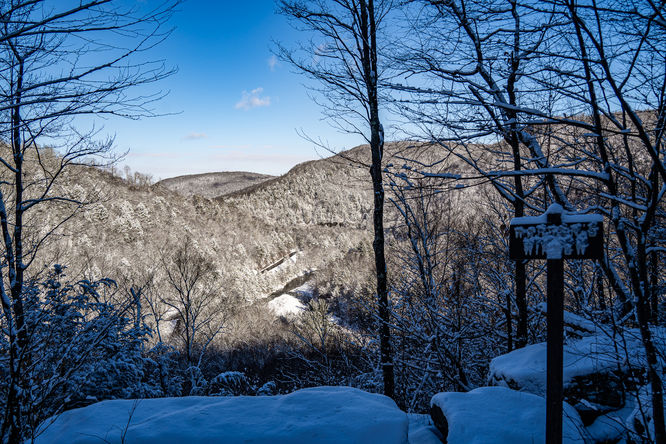
I hiked this loop in a clockwise direction starting at the Double Run Nature Trailhead. Follow Double Run Trail until it connects with the Loyalsock Trail (LT) and the Red X Trail. Turn left onto the Loyalsock Trail. At about 0.5 miles, you may noticed blue blazes up and to the right of the Loyalsock Trail. I took a quick crossover to this trail which is Canyon Vista Trail, but if you follow the LT, it will connect with Canyon Vista Trail. I did this so I could take in the view at Warren's Window. (41.46419, -76.57710).
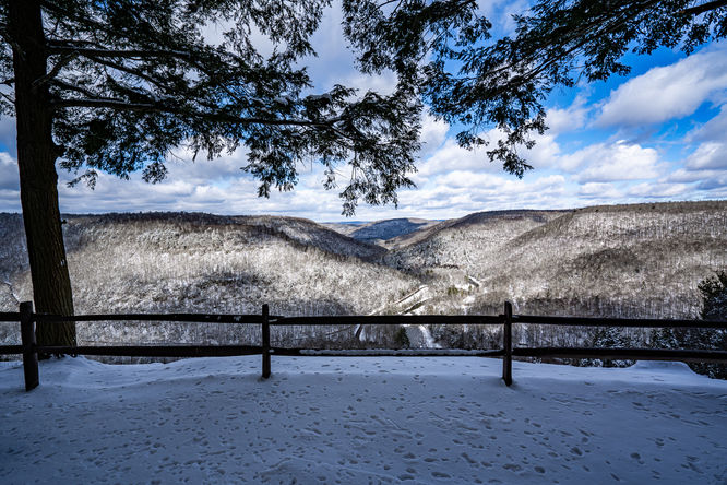
Retrace your steps on Canyon Vista Trail back to the intersection with Loyalsock Trail. At the intersection continue on the Loyalsock Trail. At roughly 1 mile you will come across yet another intersection of Loyalsock Trail and Canyon Vista Trail, at this point I opted to follow the blue blazes of Canyon Vista Trail, but either trail will lead to the same place. The trails will reconnect at some interesting rocks on the opposite of Cold Run Road at about 41.46291, -76.57046. From here the trail will lead you to Canyon Vista. This is a vista that you can drive to, expect others in months that the road is open. There is also a toilet here.
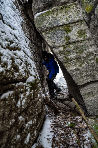
From Canyon Vista I hiked to the Rock Garden and continued into the forest. My initial intention was to follow the trail that goes out back of the Rock Garden, however I did not find trail blazes or an obvious trail in the fresh snow. I did discover an interesting rock formation beyond the Rock Garden that I have visited many times in the past. I decided to explore the various crevices' of these rocks at 41.46029, -76.57265.
Once I was done exploring these rocks, I hiked offtrail crossing over to the Loyalsock Trail and back towards Canyon Vista. I then connected with Red X Trail which I followed back to Double Run.
Worlds End State Park and the surrounding Loyalsock State Forest offers some great hiking and many options to create loop hikes. I hiked this hike after a fresh snowfall and picked the starting point that I knew would be accessible in winter conditions. The hike includes two vistas and some interesting rock formations.
Parking:
Park at the Double Run Nature Trailhead off of Route 154 within Worlds End State Park. Coordinates are 41.46581, -76.57864. There is space for a couple cars.
Hike:
I hiked this loop in a clockwise direction starting at the Double Run Nature Trailhead. Follow Double Run Trail until it connects with the Loyalsock Trail (LT) and the Red X Trail. Turn left onto the Loyalsock Trail. At about 0.5 miles, you may noticed blue blazes up and to the right of the Loyalsock Trail. I took a quick crossover to this trail which is Canyon Vista Trail, but if you follow the LT, it will connect with Canyon Vista Trail. I did this so I could take in the view at Warren's Window. (41.46419, -76.57710).
Retrace your steps on Canyon Vista Trail back to the intersection with Loyalsock Trail. At the intersection continue on the Loyalsock Trail. At roughly 1 mile you will come across yet another intersection of Loyalsock Trail and Canyon Vista Trail, at this point I opted to follow the blue blazes of Canyon Vista Trail, but either trail will lead to the same place. The trails will reconnect at some interesting rocks on the opposite of Cold Run Road at about 41.46291, -76.57046. From here the trail will lead you to Canyon Vista. This is a vista that you can drive to, expect others in months that the road is open. There is also a toilet here.
From Canyon Vista I hiked to the Rock Garden and continued into the forest. My initial intention was to follow the trail that goes out back of the Rock Garden, however I did not find trail blazes or an obvious trail in the fresh snow. I did discover an interesting rock formation beyond the Rock Garden that I have visited many times in the past. I decided to explore the various crevices' of these rocks at 41.46029, -76.57265.
Once I was done exploring these rocks, I hiked offtrail crossing over to the Loyalsock Trail and back towards Canyon Vista. I then connected with Red X Trail which I followed back to Double Run.