Loading...

WINTER SALE! 50% OFF Supporter Accounts — now through January 31st. Learn More.

Dobie Mountain Hike

Dobie Mountain is not as popular as its neighbor, Humpback Rocks, but is a nice hike if you want to get away from the crowds. Less than 1.1 miles into the hike you will reach the Glass Hollow Overlook that has some great views of Rockfish Valley. We had lunch at the Paul C. Wolfe Shelter and then returned via the Albright Loop Trail with a side visit to a visible plane wreck just off the trail.

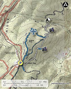
We parked at the Humpback Rocks Parking Area (MP6 on the Blue Ridge Parkway). This hike can be done as a shortened 4.0 mile hike or as a 6.8 mile hike if you choose to go to the shelter for lunch.

The blue-blazed trail begins to the right of the picnic table and directly in front of the first parking spot, do not take the well signed Albright Loop Trail to the left of the picnic table or you will miss the Glass Hollow Overlook. There is no sign for this trail, it is the Old Howardsville Turnpike and will take you to the A.T. intersection in 0.3 miles. At the intersection take a sharp left onto the white blazed A.T. heading north. Continue 0.8 miles to reach the spur trail to the Glass Hollow Overlook. Take a right on the blue-blazed spur trail reaching the overlook in 0.2 miles for some great views of Rockfish Valley.

Return to the A.T. and take a right heading north. In 0.3 miles you will pass the first intersection of the Albright Loop trail, go another 0.1 miles to reach the second intersection of the Albright Loop Trail. If you want to do the short 4.0 mile hike, take a left at this intersection. If going to the shelter, bear right staying on the A.T. going north.

The next 1.4 miles down to the shelter is a fairly gentle series of switchbacks, dropping 700 ft. At the 0.5 mile mark there is an overlook with views of Scott Mountain and Bear Den Mountain in Shenandoah National Park to the north. I-64 will also be visible. Just before the shelter you will cross over Mill Creek and to the right you will see a beautiful granite bench that is a Memorial to John Donovan, a long time Old Dominion Appalachian Trail Club (ODATC) member who died in California while hiking the Pacific Crest Trail. The ODATC maintained shelter is one of the nicest on the A.T. in VA. After lunch, head back south on the A.T. and at the first intersection you arrive at take a right onto the blue-blazed Albright Loop Trail.

Go about 0.7 miles and after the second switchback look uphill to the South for plane wreckage that is visible from the trail. Mr. Henri Weems provided information that it is a Beechcraft that crashed in 1964 and was found a year later by ginseng hunters, no flight plan had been filed. Please respect this site and adhere to the Leave No Trace principle "Leave what you find".

Continue on the Albright Loop trail, passing the intersection of the east portion of the Albright Loop trail, arriving at the Humpback Rocks Parking area in 1.3 miles.

Explore 38 trails near Afton, VA

Know Before You Go

  • Dobie Mountain offers a less crowded alternative to Humpback Rocks with options for a 4.0, 6.3 or 6.8 mile hike.
  • The hike includes the Glass Hollow Overlook with views of Rockfish Valley, and the Paul C. Wolfe Shelter, a well-maintained shelter on the A.T.
  • The Albright Loop Trail portion features a visible plane wreck from 1964, reminding hikers to respect the site and practice Leave No Trace principles.
Interactive topographic map for Dobie Mountain Hike located in Afton, VA. Click the "View Map" button to load GPS coordinates and trail markers.
Get directions
Distance
6.3 mi
Difficulty
Moderate
Type
Loop
Est. Time
3.2 hrs
Elev. Gain
1,260'
Rating
3.9
Added
January 25, 2025
Updated
April 04, 2025

Weather Forecast

Loading...
Total Change
1,110'
Ascent
1,260'
Descent
1,260'
Loading...

Download the GPX Data for Offline Use

Supporters get exclusive access to download trail routes to the MyHikes app for offline use. Stay prepared on your adventure, even without an internet connection! Become a Supporter today to unlock this feature and hike with confidence.

Download Dobie Mountain Hike GPX Data to the MyHikes Mobile App

Features

Vista / Lookout Point
Dogs
Mountain Summit
Camping
Appalachian Trail logo Appalachian Trail hike

Points of interest

  1. Parking

    37.968513, -78.896808
  2. Main Trailhead

    37.968559, -78.896513

Safety information

For your own safety: plan ahead, let someone know where you'll be, and hike at your own risk.

Hazards

Snakes (Rattlesnakes, Copperheads, others)
Poison Ivy or Poison Oak

Availability

All seasons

Surface type

Dirt

Trip Reports (Reviews)

Rated 3.94 out of 5 based on 32 ratings.

Ready to help fellow hikers? Add a trip report to share your experience and provide valuable insights for other hikers!

By: Chris OD
6.3 miles / 10.1 km
November 02, 2019
Crystal clear blue skies and a brisk 35F at 10 AM when I started. The Humpback Rocks parking lot was already overflowing. Thankfully none of them followed me North! Only saw a couple of other hikers as I headed North. Chatted with a through-hiker at the shelter. He was flip flopping and was only 150 miles north of finishing the trail. The loop trail on the way back to the parking lot was a little more challenging that expected. Most turns are not marked on the trail, and with the forest covered in freshly fallen leaves it was not always obvious where the trail was.. I had to stop, look, and think 4 or 5 times to make sure I was still on the trail. Also, it's mostly uphill all the way back to the car. It's never steep, but be warned if 3ish miles uphill is not something you want to do. Did the route as suggested here in 3:15 and stopped at Blue Mountain Brewing for a post hike beer on the way home.
Legacy Review
By: Carly
6.3 miles / 10.1 km
September 29, 2019
This is a great trail that I have come back to a couple times. The shelter is clean and the stream next to it is peaceful. You won't run into too many groups, but you may run into a non-aggressive bear. We had no problems when we ran into said bear, but I would read up on how to safely deal with a bear encounter before doing this hike and keep your dogs leashed for safety. The airplane crash site is awesome and relatively well maintained. It does take a good eye and some time to find the wreck. I would recommend bringing at least 50 oz of water per a person to ensure you don't run out.
Legacy Review
By: Irina Allen
6.3 miles / 10.1 km
July 28, 2019
Hiked today. Followed "hikingupward" directions, made it to the shelter. Nice shelter indeed, with very peaceful stream - saw 2 through hikers refilling water bottles. I did not see any granite bench by the shelter, and I really looked. Now, my real goal was to find plane crash site. So, I turned right to blue trail from AT, walked almost 1.5 mile, did not spot any plane crash site. Maybe it's overgrowth, or just me - I don't know. After 1.5 mile blue trail started to go steeply up. I was tired, and figured, just forget it, came back to AT and retraced my steps to parking lot. Surprisingly - although humpback mountain parking lot was full at 0915 am, I hiked all the way to the shelter by myself.
Legacy Review
No community routes found. To add your own hike as a Community Route for this Trail guide, leave a Trip Report with an attached GPX file.

Popular categories

Scenic mountain view representing vista trails
Vista trails
Scenic gorge of cascades representing waterfall trails
Waterfall hikes
Rugged mountain terrain representing summit trails
Summit trails
Scenic mountain view representing dog-friendly trails
Dog-friendly
Scenic campsite with a view representing camping trails
Camping trails
Appalachian Trail logo representing A.T. hikes
A.T. hikes

You May Also Like

25 Best Day Hikes in North Carolina - Discover the top 25 best day hikes in North Carolina, from breathtaking waterfalls to mountain peaks. Explore hidden gems, scenic views, and trails suitable for all skill levels, perfect for your next outdoor adventure.
Explore

25 Best Day Hikes in North Carolina

Discover the top 25 best day hikes in North Carolina, from breathtaking waterfalls to mountain peaks. Explore hidden gems, scenic views, and trails suitable for all skill levels, perfect for your next outdoor adventure.

Read
🍪 We use cookies to learn about site usage and to serve map tiles. You may block cookies manually in the browser. By continuing you agree. Learn more