Loading...

WINTER SALE! 50% OFF Supporter Accounts — now through January 31st. Learn More.

Doane's Falls

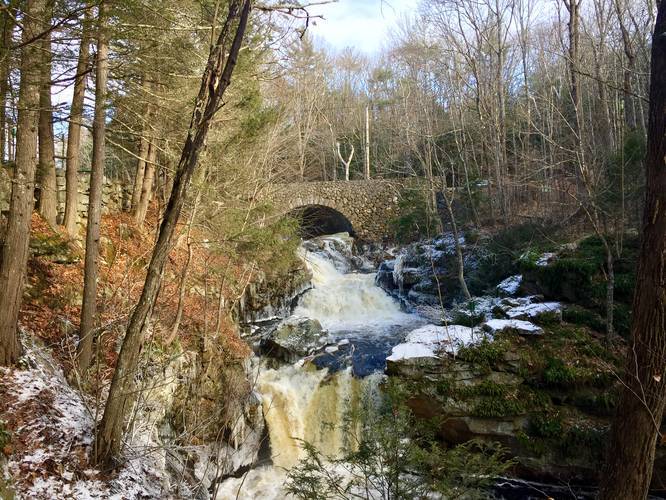
The Doane's Falls Trail in Royalston, Massachusetts is an easy 0.2 mile out-and-back hike to the iconic multi-tiered waterfall, Doane's Falls. Doane's Falls is one of the most scenic waterfalls in western Massachusetts and the best part is, its just a short walk down to views.

This hike technically only spans the Upper and Middle Falls; however, you can continue further downhill along the blue-blazed trail to a lookout to the Lower Falls.

Despite only spanning the Upper and Middle Falls, you'll end up seeing more than two cascades of waterfalls before heading back to parking.

Parking: Parking can be found at the intersection of Doane Hill Rd and Athol Rd in Royalston.

Warning: Due to rapid currents, swimming, wading, and fishing are all prohibited here. Also beware of the steep slopes near the cliffs by the creek.
Explore 166 trails near Royalston, MA

Know Before You Go

  • Doane's Falls Trail is an easy, short (0.2 mile) hike in Royalston, MA, leading to scenic views of Upper and Middle Doane's Falls.
  • The trail offers access to a lookout point for Lower Falls via a blue-blazed trail, providing views of multiple cascades.
  • Swimming, wading, and fishing are prohibited due to dangerous currents, and hikers should be cautious of steep slopes near the creek and cliffs.
Interactive topographic map for Doane's Falls located in Royalston, MA. Click the "View Map" button to load GPS coordinates and trail markers.
Get directions
Distance
0.2 mi
Difficulty
Easy
Type
Out-and-Back
Est. Time
6 min
Elev. Gain
65'
Rating
5.0
Added
December 29, 2018
Updated
February 19, 2019

Weather Forecast

Tonight
Low 17°F
Cloudy then Light Snow Likely
Saturday
High 32°F
Snow
Saturday Night
Low 23°F
Mostly Cloudy
Sunday
High 34°F
Chance Light Snow
Sunday Night
Low 14°F
Chance Light Snow then Mostly Cloudy
M.L. King Jr. Day
High 27°F
Mostly Sunny
Monday Night
Low 7°F
Partly Cloudy
Tuesday
High 14°F
Mostly Sunny
Tuesday Night
Low 2°F
Mostly Clear
Wednesday
High 21°F
Partly Sunny
Wednesday Night
Low 12°F
Slight Chance Snow Showers
Thursday
High 29°F
Chance Snow Showers
Thursday Night
Low 11°F
Chance Snow Showers
Friday
High 23°F
Slight Chance Snow Showers
Loading...
Total Change
37'
Ascent
65'
Descent
65'
Loading...

Download the GPX Data for Offline Use

Supporters get exclusive access to download trail routes to the MyHikes app for offline use. Stay prepared on your adventure, even without an internet connection! Become a Supporter today to unlock this feature and hike with confidence.

Download Doane's Falls GPX Data to the MyHikes Mobile App

Features

Vista / Lookout Point
Dogs
Waterfalls

Points of interest

  1. Parking

    42.649921, -72.200763
  2. Main Trailhead

    42.649859, -72.200893

Safety information

For your own safety: plan ahead, let someone know where you'll be, and hike at your own risk.

Markers

Blaze Color

Blue

Availability

All seasons

Surface type

Dirt

Trip Reports (Reviews)

Rated 5.0 out of 5 based on 1 rating.

Ready to help fellow hikers? Add a trip report to share your experience and provide valuable insights for other hikers!

0.2 miles / 0.3 km
May 16, 2020
This recording is from the lower falls parking lot, up the blue blaze to the top of the falls parking lot and back down the road to the lower lot.
Hiking
0.2 miles / 0.3 km
December 26, 2018
Dogs Hiking

Explore other routes for this Trail guide, added by the MyHikes' community via Trip Reports (Reviews). To add your own hike as a Community Route for this Trail guide, leave a Trip Report and attached your GPX file!

Popular categories

Scenic mountain view representing vista trails
Vista trails
Scenic gorge of cascades representing waterfall trails
Waterfall hikes
Rugged mountain terrain representing summit trails
Summit trails
Scenic mountain view representing dog-friendly trails
Dog-friendly
Scenic campsite with a view representing camping trails
Camping trails
Appalachian Trail logo representing A.T. hikes
A.T. hikes

You May Also Like

Colorado's Million Dollar Highway - Plan a day's drive adventure along the iconic Million Dollar Highway in Colorado. Explore the best short trails, roadside stops, waterfalls, vistas, ghost towns, and hot springs within a ~6 hour road trip.
Explore

Colorado's Million Dollar Highway

Plan a day's drive adventure along the iconic Million Dollar Highway in Colorado. Explore the best short trails, roadside stops, waterfalls, vistas, ghost towns, and hot springs within a ~6 hour road trip.

Read
Glacier's Going-to-the-Sun Road - Discover the breathtaking beauty of Glacier National Park along the iconic Going-to-the-Sun Road. From stunning roadside stops to picturesque waterfalls and vistas, this engineering marvel offers endless opportunities for exploration.
Explore

Glacier's Going-to-the-Sun Road

Discover the breathtaking beauty of Glacier National Park along the iconic Going-to-the-Sun Road. From stunning roadside stops to picturesque waterfalls and vistas, this engineering marvel offers endless opportunities for exploration.

Read
🍪 We use cookies to learn about site usage and to serve map tiles. You may block cookies manually in the browser. By continuing you agree. Learn more