The Discovery Loop Trail at Quail Hollow Ranch County Park near Felton, California is an easy 1-mile hike that features beautiful wildflowers, fragrant old-growth eucalyptus trees, and horses on the ranch.
Trails
This hike follows one named trail - Discovery Loop.
Hike Description
This track first heads towards and around the Park Office to reach the main trailhead which is located due east behind the Park Office. Here, the trail begins following the outline of the ranch's horse fences. Along the way, hikers can often find horses walking around.
Along the hike, generally during the Spring, hikers will find an abundance of wildflowers including the Boony Doon Manzanita, Santa Cruz Wallflower, Ben Lomond Spineflower, Ben Lomond Buckwheat, and wild lupine.
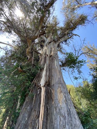
Old-Growth Eucalyptus Trees - Mile 0.8
Around mile 0.8, hikers will encounter two or three very large old-growth eucalyptus trees which fragrance can be smelled down-wind on the trail. Their scent, color, and size make these trees a must-see along the hike.
Finally, hikers will reach the main parking lot to finish the hike, for approximately 1-mile loop.
Warnings
Rattlesnakes: Note that this area is known for rattlesnakes, which can be found on-trail sunning themselves or hiding just off-trail in tall grass. Watch your step and be on the lookout for rattlesnakes.
Sun exposure: This trail does not have a lot of shade, thus the sun exposure level is fairly high.
Prohibited
No dogs on trails, no drones, no fishing, no camping, no collecting minerals/plants/animals, no smoking.
Trails
This hike follows one named trail - Discovery Loop.
Hike Description
This track first heads towards and around the Park Office to reach the main trailhead which is located due east behind the Park Office. Here, the trail begins following the outline of the ranch's horse fences. Along the way, hikers can often find horses walking around.
Along the hike, generally during the Spring, hikers will find an abundance of wildflowers including the Boony Doon Manzanita, Santa Cruz Wallflower, Ben Lomond Spineflower, Ben Lomond Buckwheat, and wild lupine.
Old-Growth Eucalyptus Trees - Mile 0.8
Around mile 0.8, hikers will encounter two or three very large old-growth eucalyptus trees which fragrance can be smelled down-wind on the trail. Their scent, color, and size make these trees a must-see along the hike.
Finally, hikers will reach the main parking lot to finish the hike, for approximately 1-mile loop.
Warnings
Rattlesnakes: Note that this area is known for rattlesnakes, which can be found on-trail sunning themselves or hiding just off-trail in tall grass. Watch your step and be on the lookout for rattlesnakes.
Sun exposure: This trail does not have a lot of shade, thus the sun exposure level is fairly high.
Prohibited
No dogs on trails, no drones, no fishing, no camping, no collecting minerals/plants/animals, no smoking.