Dingmans Falls Trail at Delaware Water Gap National Recreation Area near Dingmans Ferry, Pennsylvania is an easy 0.8-mile out-and-back universally-accessible trail that features two massive waterfalls including Silverthread Falls (80-feet) and Dingmans Falls (130-feet).
Universal Access
This trail is universally accessible from the parking lot all the way to the viewing platform at the base of Dingmans Falls. The trail follows a boardwalk, crushed gravel, and a paved surface.
Popularity
This is one of the most-popular trails at Delaware Water Gap National Recreation Area. You will likely find other hikers while out on the trail, even during a cold quiet weekday.
Hike Description
This hike begins at the main parking lot for Dingmans Falls, located at the very end of Dingmans Falls Road, and follows the main trail from the parking lot as it heads into a rhododendron-filled mountain valley. The trail first heads across Dingmans Creek, following a scenic footbridge that provides views of the creek with its banks full of old rhododendrons.
Silverthread Falls (80-feet tall) - Mile 0.06
Soon into the hike, around mile 0.06 (just a few hundred-feet in), hikers will find the two-tiered 80-foot tall waterfall known as Silverthread Falls. A keen-eyed hiker may notice the flat-cut rock that lines the waterfall's gorge -- these square-cut rocks are not natural, so it shows that the gorge's bedrock was at one point carved out for retail by a mining company. Despite the mix of natural and unnatural rock formations, Silverthread Falls is one of the most-scenic waterfalls within the Delaware Water Gap.
After checking out Silverthread Falls, hikers will follow the boardwalk of the Dingmans Creek Trail as it cuts its way through the fern and moss-filled forest. The trail will cross Dingmans Creek one more time on the way to Dingmans Falls, which provides hikers with another scenic creek view. The trail will then bend around a corner, with a sign labeled "Dingmans Falls".
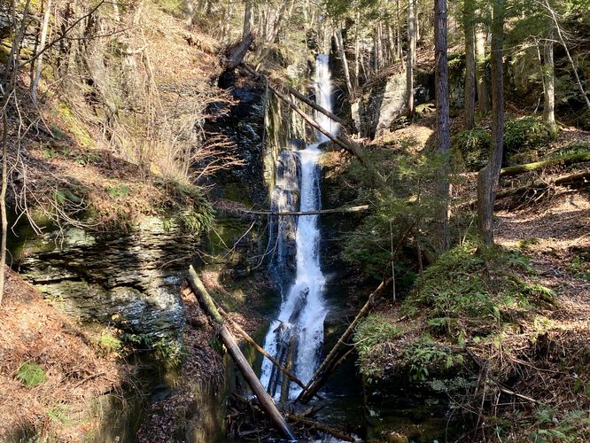
Dingmans Falls - Mile 0.37
Around mile 0.37, hikers will reach the end of the universal access path with a stunning view of the 130-foot tall Dingmans Falls. There's an additional waterfall that spills into Dingmans Creek, located just adjacent to Dingmans Falls, that simply adds to the stunning scenery. Dingmans Falls cascades down several series of bedrock to reach the creek, cascading approximately 130-feet down.
After visiting Dingmans Falls, hikers can choose to head up the staircase nearby to reach the top of Dingmans Falls; however, the best view is by far from its base. If you choose to hike out after visiting Dingmans Falls, you'll complete this easy hike at about 0.8-miles.
Parking
Hikers will find a very large parking lot at the coordinates provided at the end of Dingmans Falls Road. The lot is large enough to fit a few dozen vehicles as of December 2023.
Pets
Dogs are not allowed on this trail unless it's a service dog.
Universal Access
This trail is universally accessible from the parking lot all the way to the viewing platform at the base of Dingmans Falls. The trail follows a boardwalk, crushed gravel, and a paved surface.
Popularity
This is one of the most-popular trails at Delaware Water Gap National Recreation Area. You will likely find other hikers while out on the trail, even during a cold quiet weekday.
Hike Description
This hike begins at the main parking lot for Dingmans Falls, located at the very end of Dingmans Falls Road, and follows the main trail from the parking lot as it heads into a rhododendron-filled mountain valley. The trail first heads across Dingmans Creek, following a scenic footbridge that provides views of the creek with its banks full of old rhododendrons.
Silverthread Falls (80-feet tall) - Mile 0.06
Soon into the hike, around mile 0.06 (just a few hundred-feet in), hikers will find the two-tiered 80-foot tall waterfall known as Silverthread Falls. A keen-eyed hiker may notice the flat-cut rock that lines the waterfall's gorge -- these square-cut rocks are not natural, so it shows that the gorge's bedrock was at one point carved out for retail by a mining company. Despite the mix of natural and unnatural rock formations, Silverthread Falls is one of the most-scenic waterfalls within the Delaware Water Gap.
After checking out Silverthread Falls, hikers will follow the boardwalk of the Dingmans Creek Trail as it cuts its way through the fern and moss-filled forest. The trail will cross Dingmans Creek one more time on the way to Dingmans Falls, which provides hikers with another scenic creek view. The trail will then bend around a corner, with a sign labeled "Dingmans Falls".
Dingmans Falls - Mile 0.37
Around mile 0.37, hikers will reach the end of the universal access path with a stunning view of the 130-foot tall Dingmans Falls. There's an additional waterfall that spills into Dingmans Creek, located just adjacent to Dingmans Falls, that simply adds to the stunning scenery. Dingmans Falls cascades down several series of bedrock to reach the creek, cascading approximately 130-feet down.
After visiting Dingmans Falls, hikers can choose to head up the staircase nearby to reach the top of Dingmans Falls; however, the best view is by far from its base. If you choose to hike out after visiting Dingmans Falls, you'll complete this easy hike at about 0.8-miles.
Parking
Hikers will find a very large parking lot at the coordinates provided at the end of Dingmans Falls Road. The lot is large enough to fit a few dozen vehicles as of December 2023.
Pets
Dogs are not allowed on this trail unless it's a service dog.