Diana's Baths at White Mountain National Forest in Bartlett, New Hampshire is an easy 1.2-mile out-and-back hike that leads to the scenic multi-tiered waterfalls known as Diana's Baths.
Hike
This hike begins at the main trailhead located on the west side of West Side Road in Bartlett, NH. The main trailhead is located on the west side of the parking lot and follows yellow blazes through the forest. Initially the trail heads downhill along a short switchback before heading gradually uphill toward the waterfalls. The trail can be very muddy especially after a recent rain or during snow melt season, so wear the proper footwear depending on the season and conditions.
Diana's Baths - Mile 0.6
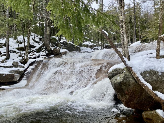
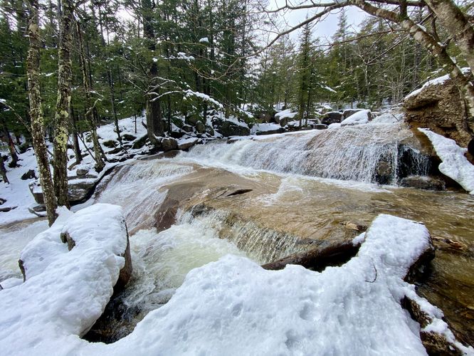
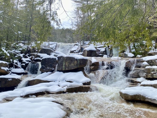
At mile 0.6 hikers will reach the lower waterfalls at Diana's Baths. Here you'll find a ~7-foot tall two-tiered waterfall that cascades down Lucy Brook. Just upstream from the lower waterfall is a view of both tiers of the cascade. Just above lower falls is a concrete enclosure that was once used by the mill that was built on-site here in the late 1860s. Upstream from that is a view of the two upper-tier waterfalls that cascade Lucy Brook's water downstream and are about 4-foot tall.
The hike out follows the same path that you hiked-in on, but is a bit easier as most of the walk is downhill. You'll complete this out-and-back hike for 1.2-miles once you reach the parking lot.
Parking
As of March 2024, there's a $5 parking fee with a pay station at the parking lot. The parking lot size is large enough to fit a couple dozen vehicles and can fill up fairly quickly by late morning.
Pets
Dogs are allowed only if leashed and must be cleaned up after.
History
As translated from the historical information sign: "In 1863 George C. Lucy purchased 5 acres of land on which you're now standing. Seeing the potential to harness the downward plunge of water at this site, he soon after constructed a sawmill. For a century, the Lucy family operated the mill, updating its technology several times. In the 1920's the mill's waterwheel was replaced with a turbine and cement easing, the remnants of which are visible along the shoreline in front of you.
Before the Lucy family built the mill, the waterfalls attracted visitors. The Abenaki tribe called the area "Water Fairies' Spring". By the late 1860's, the name "Diana's Baths" first appeared on maps - referencing the Roman goddess. The Lucy family, recognizing the potential of tourism, built a 3-story boarding house in the 1890s and a souvenir shop in 1910. In 1973, the family sold Diana's Baths and the surrounding land to the U.S. Forest Service."
Hike
This hike begins at the main trailhead located on the west side of West Side Road in Bartlett, NH. The main trailhead is located on the west side of the parking lot and follows yellow blazes through the forest. Initially the trail heads downhill along a short switchback before heading gradually uphill toward the waterfalls. The trail can be very muddy especially after a recent rain or during snow melt season, so wear the proper footwear depending on the season and conditions.
Diana's Baths - Mile 0.6
At mile 0.6 hikers will reach the lower waterfalls at Diana's Baths. Here you'll find a ~7-foot tall two-tiered waterfall that cascades down Lucy Brook. Just upstream from the lower waterfall is a view of both tiers of the cascade. Just above lower falls is a concrete enclosure that was once used by the mill that was built on-site here in the late 1860s. Upstream from that is a view of the two upper-tier waterfalls that cascade Lucy Brook's water downstream and are about 4-foot tall.
The hike out follows the same path that you hiked-in on, but is a bit easier as most of the walk is downhill. You'll complete this out-and-back hike for 1.2-miles once you reach the parking lot.
Parking
As of March 2024, there's a $5 parking fee with a pay station at the parking lot. The parking lot size is large enough to fit a couple dozen vehicles and can fill up fairly quickly by late morning.
Pets
Dogs are allowed only if leashed and must be cleaned up after.
History
As translated from the historical information sign: "In 1863 George C. Lucy purchased 5 acres of land on which you're now standing. Seeing the potential to harness the downward plunge of water at this site, he soon after constructed a sawmill. For a century, the Lucy family operated the mill, updating its technology several times. In the 1920's the mill's waterwheel was replaced with a turbine and cement easing, the remnants of which are visible along the shoreline in front of you.
Before the Lucy family built the mill, the waterfalls attracted visitors. The Abenaki tribe called the area "Water Fairies' Spring". By the late 1860's, the name "Diana's Baths" first appeared on maps - referencing the Roman goddess. The Lucy family, recognizing the potential of tourism, built a 3-story boarding house in the 1890s and a souvenir shop in 1910. In 1973, the family sold Diana's Baths and the surrounding land to the U.S. Forest Service."