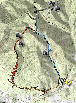
Loading...

🎉 Enjoy a Free 7-Day Supporter Trial and Unlock Exclusive Perks — No Credit Card Required. Learn more.

Devil's Marbleyard Hike

Directions
Map
Pictures
Send to App
Distance:
11.1 Miles / 17.9 km
Type:
Loop
Difficulty:
Hard
Time to Hike:
5 hours, ~33 minutes
Features:
Appalachian Trail hike
Surface Type:
Dirt
Park:
Jefferson National Forest
Town:
Natural Bridge Station, Virginia
Directions:
37.571187, -79.491901
Added:
February 28, 2025
Updated:
April 05, 2025
Copy Trail Link Hiking this trail? Send a friend or family member a link to this trail guide for your own safety. Hike at your own risk (disclaimer)
Loading...
Loading...
1,741'

Total Change
2,638'

Ascent
2,644'

Descent

Download the Trail Route for Offline Use

Supporters get exclusive access to download trail routes to the MyHikes app for offline use. Stay prepared on your adventure, even without an internet connection! Become a Supporter today to unlock this feature and hike with confidence.

Send to App

Devil's Marbleyard Hike

There are two versions of this hike. The first passes the Devil's Marbleyard, a hillside of boulders with some as large as a truck, and continues down the Gunter Ridge Trail. The second version adds a 3.0 mile out and back hike along the Appalachian Trail, which reaches one of the most spectacular 360° panoramas in Virginia.

Both Hikes:
From the parking area cross the footbridge over the east fork of Elk Creek on the blue blazed Belfast Trail. Pass the stone pillars of the old Powhatan summer camp, and in 100 yards cross the intersection of the Glenwood Horse Trail (GHT). Continue straight and in 200 yards there is a large camping area among what's left of the Powhatan Camp building foundations.

The Belfast Trail trail veers left here, crossing a creek, then arriving at another junction of the GHT. Stay right following the blue blazed Belfast Trail. From this point there are no further blazes along the Belfast Trail. The trail will become steeper crossing a stream two more times before reaching the bottom tip of Devil's Marbleyard in 1.0 miles.

The trail stays to the right of Devils' Marbleyard, and in 0.1 miles there is access through the scrub to the main boulder field. If you spend some time rock-hopping make sure to rejoin the Belfast Trail at the same point you entered, as there isn't any trail access higher in the boulder field. Continue up the Belfast Trail as it veers away from Devil's Marbleyard through a ravine, then arrives at the top of the ridge and junction of the Gunter Ridge Trail in 0.9 miles.

For The Additional 3.0 Mile Out/Back Along the AT:
Turn right and in 0.5 miles reach the end of the Belfast Trail and intersection of the Appalachian Trail (AT). Stay right along the ridge on the now white blazed AT as it continues down to the right, through a small saddle, and back up before arriving at a 100 yard clear section of the AT. Just before the open area of the trail reenters the tree line turn left uphill through the underbrush, and in 30 yards reach the ridge. This clearing, along the un-maintained Sulphur Spring Trail, is known as the 'Helicopter Pad', and has one of the most spectacular 360° views in the state of Virginia.

To continue, retrace the route 1.5 miles back to the intersection of the Gunter Ridge Trail you passed earlier.

Both Hikes:
If you are hiking the shorter loop only, turn left on the Gunter Ridge Tail. For the the out/back addition on the AT, now continue straight on the Gunter Ridge Trail.

The Gunter Ridge Trail is not blazed, and is marked on the map here in red. In 0.3 miles pass through a small saddle, then descend along the north side of the mountain before the trail heads back to the ridge line. Once along the ridge there are views in every direction. A fire, caused by lightning, burnt this section of Gunter Ridge in 2002 and almost no large trees remain.

Begin to descend more steeply, and the trail makes 14 switchbacks before leveling out near the valley floor. Pass through a wooden horse gate and follow the trail to the left. Cross Little Hellgate Creek, and in 0.5 miles the Gunter Ridge Trail ends at the Glenwood Horse Trail (GHT). This section of the GHT is an old forestry road.

Turn left on the orange GHT. There aren't any trail markings on the GHT at this point, so don't be concerned if you don't see any. The GHT will wind around the mountain, then in 0.8 miles stay right following the orange diamonds where a side FS road leads uphill. In 0.3 miles pass another FS road that turns back to the left, and 200 yards further make a sharp switchback to the left continuing to follow the orange diamonds. 0.8 miles from here the GHT reaches the intersection of the Belfast Trail you ascended earlier.

Turn right, and in 60 yards stay right again following the orange diamonds. In 240 yards turn left at the arrow and orange diamonds, cross a small stream, and in 300 yards reach the intersection of the Belfast Trail. Turn right on the Belfast Trail for 100 yards re-crossing the east fork of Elk Creek and arrive back at the parking area.

Explore 28 trails near Natural Bridge Station, VA
  1. Parking

    37.571187, -79.491901
  2. Main Trailhead

    37.571147, -79.491556
No community routes found. To add your own hike as a Community Route for this Trail guide, leave a Trip Report with an attached GPX file.

Hazards

Ticks - Lyme Disease More Info (CDC)
Snakes
Poison Ivy/Oak
Rockfalls / Ledges / or Scrambles

Seasons

All

Weather Forecast

In Natural Bridge Station, VA

Explore Hiking Trails

You May Also Like

New York's Best Waterfalls - Whether you're planning a day hike, roadside stop, or a leisurely short walk, this guide provides hikers, travelers, and locals alike with 63 different locations to over 100 scenic waterfalls to help plan your next adventure!
Explore

New York's Best Waterfalls

Whether you're planning a day hike, roadside stop, or a leisurely short walk, this guide provides hikers, travelers, and locals alike with 63 different locations to over 100 scenic waterfalls to help plan your next adventure!

Read
25 Best Day Hikes in North Carolina - Discover the top 25 best day hikes in North Carolina, from breathtaking waterfalls to mountain peaks. Explore hidden gems, scenic views, and trails suitable for all skill levels, perfect for your next outdoor adventure.
Explore

25 Best Day Hikes in North Carolina

Discover the top 25 best day hikes in North Carolina, from breathtaking waterfalls to mountain peaks. Explore hidden gems, scenic views, and trails suitable for all skill levels, perfect for your next outdoor adventure.

Read

Before you boogie...

Find our trail guides useful? Consider becoming a Supporter to unlock perks!

MyHikes is an indie platform that makes exploring public trails easier for everyone. The platform has no investors, no ads, and is owned and operated by one person, Dave Miller. Dave has personally mapped and written over 1,800 trail guides on MyHikes for the public to explore. MyHikes has helped millions outdoor enthusiasts plan their next adventure.

But it takes a lot of time 🕦, money 💰, work, and espresso shots ☕ to run MyHikes, including hiking , mapping , writing , and publishing new trails with high-quality (accurate) information... along with software engineering (coding) the platform like building new features, website and mobile app development (iOS and Android), site maintainance . and much much more.

Supporters unlock website and mobile app perks with an annual one-time payment of $25 (you renew) 😎👍. Or you can simply make a Donation of your choice. Otherwise, you can support us by telling your friends about MyHikes - both quick and free 🎉

Admin user profile picture

Dave Miller
MyHikes Founder