Loading...

🎉 Enjoy a Free 7-Day Supporter Trial and Unlock Exclusive Perks — No Credit Card Required. Learn more.

Devil's Bathtub Hike

Directions
Map
Pictures
Send to App
Distance:
3.2 Miles / 5.1 km
Type:
Out-and-Back
Difficulty:
Easy
Time to Hike:
1 hour, ~36 minutes
Features:
Surface Type:
Dirt
Park:
Jefferson National Forest
Town:
Norton, Virginia
Directions:
36.81866, -82.62674
Added:
February 28, 2025
Updated:
April 12, 2025
Copy Trail Link Hiking this trail? Send a friend or family member a link to this trail guide for your own safety. Hike at your own risk (disclaimer)
Loading...
Loading...
428'

Total Change
523'

Ascent
526'

Descent

Download the Trail Route for Offline Use

Supporters get exclusive access to download trail routes to the MyHikes app for offline use. Stay prepared on your adventure, even without an internet connection! Become a Supporter today to unlock this feature and hike with confidence.

Send to App

Devil's Bathtub Hike

This 3.5 mile hike in southwest Virginia takes you across more than 15 water-crossings to see a series of small waterfalls and swimming holes.  The main scenic draw of this hike is the visit to the Devils Bathtub – a beautiful sandstone formation in the streambed.

This hike is extremely popular and parking is very limited, so consider going on a quieter weekday. Also, this area is fragile, overused, and littered, so please consider bringing an empty trash bag and packing out garbage that other have left behind.

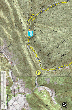
For more detailed information, go to Virginia Trail Guide’s site.

  • Mile 0.0 – From the top end of the parking lot, follow the stairway uphill to meet the trail. Take a left at the top of the stairs.
  • Mile 0.1 – Pass through a locked metal forestry gate. Descend slightly toward the stream.
  • Mile 0.2 – Cross Devils Fork stream for the first of 12-18 times (depending on seasonal water levels)
  • Mile .25 – Arrive at Devils Fork Loop Trail marker. Bear left, following the directional arrow toward the Devils Bathtub. The trail is blazed yellow. The trail will follow the streambed closely, crossing the water multiple times. Look closely for yellow blazes, as flooding has necessitated multiple reroutes.
  • Mile .65 – Look for an old coal cart overgrown with vegetation. The railroad that used to run here was used to transport timber and coal. Continue to follow the yellow blazes and cross the stream numerous times. The fifth crossing is especially tricky to find the blaze as you must look down the stream about 75 yards to find the blaze and it requires you to rock-hop across the stream to get to the blaze.
  • Mile 1.65 – Look through the woods and notice an interesting cliff-side rock formation. The rocks have almost a geometric pattern. At this point, the trail will descend rather steeply along the eroded stream bank. There should be a rope affixed to the uphill side of the trail to assist your descent.
  • Mile 1.7 – Reach a large stream crossing at the base of a small waterfall and swimming hole. Climb steeply up the opposite bank to continue on the trail.
  • Mile 1.8 – Reach a wooden sign marking your arrival at the Devils Bathtub. There are numerous social trails and footpaths cut through the woods in this area. Follow an established trail to the water’s edge. Carefully climb the rocks down to explore the area. The sandstone sinkhole that creates the bathtub will be directly below you. The bathtub is fed by a small waterfall. After you’ve finished exploring, return to the wooden sign at the top of the basin and follow the marked trail back in the way you came.
  • Mile 1.9 –Descend the bank steeply and cross the stream below the small waterfall and swimming hole.
  • Mile 1.95 – Climb the eroded bank with the rope assist uphill. Follow the yellow blazes and cross the stream numerous times.
  • Mile 3.0 – Return to the sign marking the split in the Devils Fork Loop. Be careful to continue on the trail, bearing back toward the first stream crossing.
  • Mile 3.15 – Cross Devils Fork for the final time. Climb slightly uphill, passing once again through the locked forestry gate.
  • Mile 3.2 – Descend the stairs back down to the parking area.
By HikingUpward Contributors: Christine and Adam Anderson
Explore 2 trails near Norton, VA
  1. Parking

    36.81866, -82.62674
  2. Main Trailhead

    36.819541, -82.627852
  3. Devils Bathtub

    36.81321, -82.64993
    Devils Bathtub
No community routes found. To add your own hike as a Community Route for this Trail guide, leave a Trip Report with an attached GPX file.

Hazards

Ticks - Lyme Disease More Info (CDC)
Snakes
Poison Ivy/Oak

Seasons

All

Blaze Color

Yellow

Trip Reports

Trail Guide By:
HikingUpward user profile picture
3.2 miles / 5.1 km

Weather Forecast

In Norton, VA

Explore Hiking Trails

You May Also Like

New York's Best Waterfalls - Whether you're planning a day hike, roadside stop, or a leisurely short walk, this guide provides hikers, travelers, and locals alike with 63 different locations to over 100 scenic waterfalls to help plan your next adventure!
Explore

New York's Best Waterfalls

Whether you're planning a day hike, roadside stop, or a leisurely short walk, this guide provides hikers, travelers, and locals alike with 63 different locations to over 100 scenic waterfalls to help plan your next adventure!

Read
25 Best Day Hikes in North Carolina - Discover the top 25 best day hikes in North Carolina, from breathtaking waterfalls to mountain peaks. Explore hidden gems, scenic views, and trails suitable for all skill levels, perfect for your next outdoor adventure.
Explore

25 Best Day Hikes in North Carolina

Discover the top 25 best day hikes in North Carolina, from breathtaking waterfalls to mountain peaks. Explore hidden gems, scenic views, and trails suitable for all skill levels, perfect for your next outdoor adventure.

Read

Before you boogie...

Find our trail guides useful? Consider becoming a Supporter to unlock perks!

MyHikes is an indie platform that makes exploring public trails easier for everyone. The platform has no investors, no ads, and is owned and operated by one person, Dave Miller. Dave has personally mapped and written over 1,800 trail guides on MyHikes for the public to explore. MyHikes has helped millions outdoor enthusiasts plan their next adventure.

But it takes a lot of time 🕦, money 💰, work, and espresso shots ☕ to run MyHikes, including hiking , mapping , writing , and publishing new trails with high-quality (accurate) information... along with software engineering (coding) the platform like building new features, website and mobile app development (iOS and Android), site maintainance . and much much more.

Supporters unlock website and mobile app perks with an annual one-time payment of $25 (you renew) 😎👍. Or you can simply make a Donation of your choice. Otherwise, you can support us by telling your friends about MyHikes - both quick and free 🎉

Admin user profile picture

Dave Miller
MyHikes Founder