The Denton Hill Lookout Trail at Denton Hill State Park in Ulysses, Pennsylvania is a difficult 2.5-mile out-and-back hike to the top of Denton Hill - an abandoned ski resort.
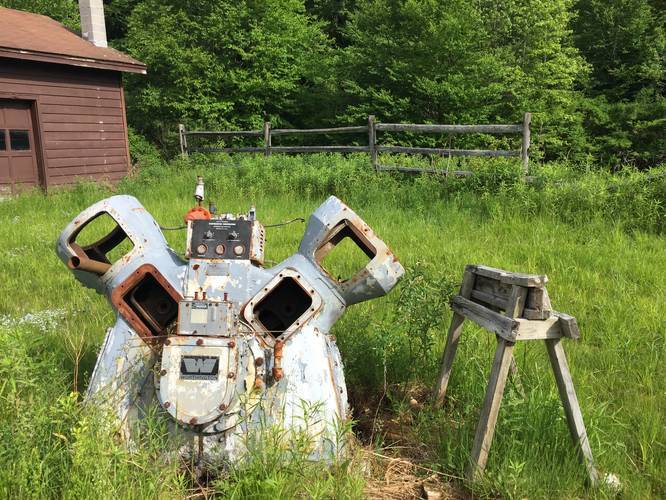
The trail starts at the main parking lot and follows a gravel road southwest toward a pond once used to make snow and a utility garage. Upon hiking toward the utility garage, you'll find old snow making machines and a ski lift station. Right after passing this section of the park, the trail will be visible straight ahead of you as it makes it ascent uphill toward the lookout.
After passing the utility garage and snow-making pond, the trail starts to hit switchbacks as it climbs Denton Hill. The grade is moderate; however, this is a difficult hike nonetheless as the trail does not level out until you reach the top of the hill.
During the late Spring and Summer, tall grass grows throughout the trail and once you reach the top, this trail technically continues along the mountain ridge; however, the grass is even taller at the top of the hill.
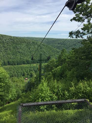
After about five switchbacks, you'll make it to the top of Denton Hill with an amazing view of the valley below and PA Route 6. You can continue hiking along the ridge (included in this GPS data is about 0.1-miles of additional trail, but the grass was very overgrown), or you can hike this back down as we did for an out-and-back hike.
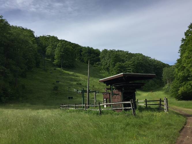
Lookout Point: After approximately 1.2-miles from the parking area, you'll reach the lookout point alongside a ski lift house. You can hike to the ski lift platform for a better view and you can even sit in a ski lift seat that was stopped strategically on the platform -- just facing the opposite direction of the view.
History: Denton Hill was developed as a ski resort in the 1950s and 1960s and was operated until late 2014 when the resort closed for downhill skiing. The state has a master plan for the park; however, it's unclear when the park may reopen for downhill skiiing. Until then, this is an amazing place to take a day hike and explore an abandoned ski resort. For those who are familiar with Western Massachusetts, this park reminded me a bit of the Mount Tom State Reservation that used to have a ski resort as well. Hikers will find plenty of remnants around the old ski slopes like grind pipes, wooden sign boards, and metal pipes leading up the hill that likely provided water for making snow.
Pets: Dogs are allowed only on leash and their waste must be carried out.
The trail starts at the main parking lot and follows a gravel road southwest toward a pond once used to make snow and a utility garage. Upon hiking toward the utility garage, you'll find old snow making machines and a ski lift station. Right after passing this section of the park, the trail will be visible straight ahead of you as it makes it ascent uphill toward the lookout.
After passing the utility garage and snow-making pond, the trail starts to hit switchbacks as it climbs Denton Hill. The grade is moderate; however, this is a difficult hike nonetheless as the trail does not level out until you reach the top of the hill.
During the late Spring and Summer, tall grass grows throughout the trail and once you reach the top, this trail technically continues along the mountain ridge; however, the grass is even taller at the top of the hill.
After about five switchbacks, you'll make it to the top of Denton Hill with an amazing view of the valley below and PA Route 6. You can continue hiking along the ridge (included in this GPS data is about 0.1-miles of additional trail, but the grass was very overgrown), or you can hike this back down as we did for an out-and-back hike.
Lookout Point: After approximately 1.2-miles from the parking area, you'll reach the lookout point alongside a ski lift house. You can hike to the ski lift platform for a better view and you can even sit in a ski lift seat that was stopped strategically on the platform -- just facing the opposite direction of the view.
History: Denton Hill was developed as a ski resort in the 1950s and 1960s and was operated until late 2014 when the resort closed for downhill skiing. The state has a master plan for the park; however, it's unclear when the park may reopen for downhill skiiing. Until then, this is an amazing place to take a day hike and explore an abandoned ski resort. For those who are familiar with Western Massachusetts, this park reminded me a bit of the Mount Tom State Reservation that used to have a ski resort as well. Hikers will find plenty of remnants around the old ski slopes like grind pipes, wooden sign boards, and metal pipes leading up the hill that likely provided water for making snow.
Pets: Dogs are allowed only on leash and their waste must be carried out.