The Denton Hill Cross-Country Ski Trail to Vista hike at Susquehannock State Forest near Coudersport, Pennsylvania is an easy 1.6-mile out-and-back trail that leads hikers out to a little-known lookout point high above PA Route 6.
This little-known trail is a hidden gem at Susquehannock State Forest and is a very small portion of the 26-mile looping Denton Hill Cross-Country Ski Trail (blue blazes).
The hike begins at the trailhead, right on PA Route 6, and follows an overgrown trail for a short distance before the trail crosses a culvert with an old wooden bridge. The trail always follows blue blazes, which can also be confusing at trail junctions.
After the culvert crossing, hikers will continue following the blue blazes for about a quarter-mile until they reach a trail sign with the number 20 on it. This junction marker indicates a fork in the trail - hikers should take a right-hand turn near this sign. Please note that on the map, the sign is located on the trail junction; however, this is not the case in real life - the trail sign is located about 20-feet south of the actual junction. Hikers should look north about 20-feet to find the trail continues to the right-hand side.
After taking a right-hand turn, hikers will continue following blue blazes, passing a large clear-cut field, before taking yet another slight right-hand turn to follow the blue blazes. After the 2nd right-hand turn, hikers will continue along the trail for about a quarter mile or less before reaching a large turn in the trail. At this turn is an old picnic table and behind the picnic table is the vista point, where this GPS track ends.
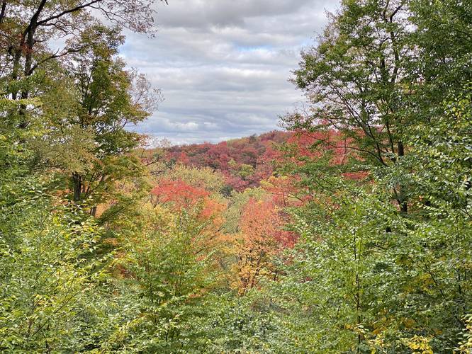
The vista point is not a sweeping vista, but more a clear-cutting tunnel that gives a small view to some mountain ranges across from PA Route 6. During the autumn, the colors here can be full of vibrant reds; however, when we did this hike, we missed the colors entirely and most of the trees here were stripped of their leaves.
The hike back is just as easy as the hike in. Reverse the route and continue following blue blazes to reach PA Route 6 and parking.
Parking
Hikers can find parking at the PA Bureau of Forestry at 3150 2nd St, Coudersport, PA 16915, which is across the street from the trailhead. Hikers will have to walk down the road from the parking area and cross PA Route 6 to reach the trailhead.
Trailhead
This trailhead is not easy to find, but you can spot it easily if you know where to look. The trailhead sits between two metal guardrails along PA Route 6, across the street from the parking area. Hikers should use extreme caution when crossing PA Route 6.
Pets
Dogs are allowed if leashed and their waste must be carried out by the hiker.
This little-known trail is a hidden gem at Susquehannock State Forest and is a very small portion of the 26-mile looping Denton Hill Cross-Country Ski Trail (blue blazes).
The hike begins at the trailhead, right on PA Route 6, and follows an overgrown trail for a short distance before the trail crosses a culvert with an old wooden bridge. The trail always follows blue blazes, which can also be confusing at trail junctions.
After the culvert crossing, hikers will continue following the blue blazes for about a quarter-mile until they reach a trail sign with the number 20 on it. This junction marker indicates a fork in the trail - hikers should take a right-hand turn near this sign. Please note that on the map, the sign is located on the trail junction; however, this is not the case in real life - the trail sign is located about 20-feet south of the actual junction. Hikers should look north about 20-feet to find the trail continues to the right-hand side.
After taking a right-hand turn, hikers will continue following blue blazes, passing a large clear-cut field, before taking yet another slight right-hand turn to follow the blue blazes. After the 2nd right-hand turn, hikers will continue along the trail for about a quarter mile or less before reaching a large turn in the trail. At this turn is an old picnic table and behind the picnic table is the vista point, where this GPS track ends.
The vista point is not a sweeping vista, but more a clear-cutting tunnel that gives a small view to some mountain ranges across from PA Route 6. During the autumn, the colors here can be full of vibrant reds; however, when we did this hike, we missed the colors entirely and most of the trees here were stripped of their leaves.
The hike back is just as easy as the hike in. Reverse the route and continue following blue blazes to reach PA Route 6 and parking.
Parking
Hikers can find parking at the PA Bureau of Forestry at 3150 2nd St, Coudersport, PA 16915, which is across the street from the trailhead. Hikers will have to walk down the road from the parking area and cross PA Route 6 to reach the trailhead.
Trailhead
This trailhead is not easy to find, but you can spot it easily if you know where to look. The trailhead sits between two metal guardrails along PA Route 6, across the street from the parking area. Hikers should use extreme caution when crossing PA Route 6.
Pets
Dogs are allowed if leashed and their waste must be carried out by the hiker.