Loading...

WINTER SALE! 50% OFF Supporter Accounts — now through January 31st. Learn More.

Dennis Pond Trail

This section of the Dennis Pond Trail at Dennis Pond Conservation Area in Yarmouth, Massachusetts is an easy 0.2-mile out-and-back hike that leads to two view points along the pond.

Hike Description
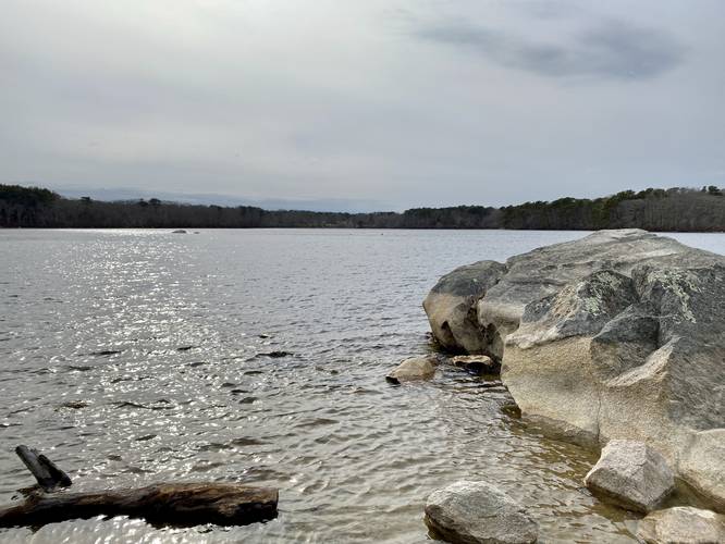
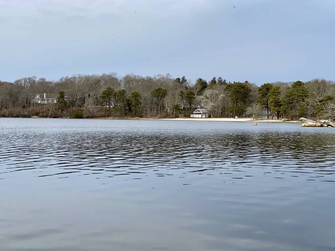
This hike begins along the eastern side of Dennis Pond and follows the red-blazed path in, heading west, toward the pond. The hike heads north to reach an open viewing area of Dennis Pond where a stone bench sits. The bench reads "Quick Dip? RKN (1937 - 2019)". You can also use this section of the pond to hop into the water during warm months. The hike then heads south and west along the edge of Dennis Pond for a very short ways before turning around. There's another view of the pond on the south side, where this GPS track turns around, but the viewing area is not open or nice like the first - it's a bit more overgrown and doesn't appear to be a great place to hop into the pond, if you're looking to swim.

Parking
Hikers will find a small parking turnout at the parking coordinates provided on Summer Street. The turnout is large enough for about 3 vehicles max.

Pets
Dogs are allowed if leashed and must be cleaned up after.

Warning
Buggy: This trail had a lot of black flies even on March 31, 2023. During the late Spring and Summer, these tiny black flies are likely a lot worse.
Explore 46 trails near Yarmouth, MA

Know Before You Go

  • The Dennis Pond Trail in Yarmouth, MA is a short, easy 0.2-mile out-and-back hike with two viewpoints of Dennis Pond.
  • The trail features a northern viewpoint with a stone bench ("Quick Dip? RKN (1937 - 2019)") suitable for swimming and a less-maintained southern viewpoint.
  • Parking is limited to about 3 vehicles, dogs are allowed on leash, and hikers should be aware of potential black fly infestations, especially during warmer months.
Interactive topographic map for Dennis Pond Trail located in Yarmouth, MA. Click the "View Map" button to load GPS coordinates and trail markers.
Get directions
Distance
0.2 mi
Difficulty
Easy
Type
Out-and-Back
Est. Time
6 min
Elev. Gain
21'
Rating
0.0
Added
April 04, 2023
Updated
April 04, 2023

Weather Forecast

Loading...
Total Change
21'
Ascent
21'
Descent
21'
Loading...

Download the GPX Data for Offline Use

Supporters get exclusive access to download trail routes to the MyHikes app for offline use. Stay prepared on your adventure, even without an internet connection! Become a Supporter today to unlock this feature and hike with confidence.

Download Dennis Pond Trail GPX Data to the MyHikes Mobile App

Features

Vista / Lookout Point
Dogs
Water Source

Points of interest

  1. Parking

    41.695978, -70.248501
  2. Main Trailhead

    41.695998, -70.248546

Safety information

For your own safety: plan ahead, let someone know where you'll be, and hike at your own risk.

Hazards

Poison Ivy or Poison Oak

Markers

Blaze Color

Red

Availability

All seasons

Surface type

Dirt

Trip Reports (Reviews)

Your opinion matters! Be the first to rate this trail.

Ready to help fellow hikers? Add a trip report to share your experience and provide valuable insights for other hikers!

No community routes found. To add your own hike as a Community Route for this Trail guide, leave a Trip Report with an attached GPX file.

Popular categories

Scenic mountain view representing vista trails
Vista trails
Scenic gorge of cascades representing waterfall trails
Waterfall hikes
Rugged mountain terrain representing summit trails
Summit trails
Scenic mountain view representing dog-friendly trails
Dog-friendly
Scenic campsite with a view representing camping trails
Camping trails
Appalachian Trail logo representing A.T. hikes
A.T. hikes

You May Also Like

Colorado's Million Dollar Highway - Plan a day's drive adventure along the iconic Million Dollar Highway in Colorado. Explore the best short trails, roadside stops, waterfalls, vistas, ghost towns, and hot springs within a ~6 hour road trip.
Explore

Colorado's Million Dollar Highway

Plan a day's drive adventure along the iconic Million Dollar Highway in Colorado. Explore the best short trails, roadside stops, waterfalls, vistas, ghost towns, and hot springs within a ~6 hour road trip.

Read
Glacier's Going-to-the-Sun Road - Discover the breathtaking beauty of Glacier National Park along the iconic Going-to-the-Sun Road. From stunning roadside stops to picturesque waterfalls and vistas, this engineering marvel offers endless opportunities for exploration.
Explore

Glacier's Going-to-the-Sun Road

Discover the breathtaking beauty of Glacier National Park along the iconic Going-to-the-Sun Road. From stunning roadside stops to picturesque waterfalls and vistas, this engineering marvel offers endless opportunities for exploration.

Read
🍪 We use cookies to learn about site usage and to serve map tiles. You may block cookies manually in the browser. By continuing you agree. Learn more