Loading...

๐ŸŽ† 50% off 4th of July sale on Supporter Accounts โ€” now through July 6! Learn More.

Deer Run Trail to META Trail

Directions
Map
Pictures
Send to App
Distance:
3.0 Miles / 4.8 km
Type:
Out-and-Back
Difficulty:
Moderate
Time to Hike:
1 hour, ~30 minutes
Features:
Surface Type:
Dirt
Park:
Sunrise Park
Town:
Suffield, Connecticut
Directions:
41.99434, -72.725122
Added:
November 20, 2019
Updated:
November 24, 2019
Copy Trail Link Hiking this trail? Send a friend or family member a link to this trail guide for your own safety. Hike at your own risk (disclaimer)
Loading...
Loading...
410'

Total Change
577'

Ascent
599'

Descent

Download the Trail Route for Offline Use

Supporters get exclusive access to download trail routes to the MyHikes app for offline use. Stay prepared on your adventure, even without an internet connection! Become a Supporter today to unlock this feature and hike with confidence.

Send to App

Deer Run Trail to META Trail

The Deer Run Trail to META Trail at Sunrise Park in Suffield, Connecticut is a moderate 3-mile out-and-back hike that features a vista point and includes a hike along the Metacomet Trail.

This hike begins at the main parking lot at Sunrise Park and first follows the Deer Run Trail. The Deer Run Trail is a fairly steep trail that leads up the mountain and connects to the Metacomet Trail. Further down the Metacomet Trail is a beautiful lookout point of the valley. Deer Run follows green blazes up the mountain that connects to the Metacomet Trail (blue blazes). The hike up to the Metacomet Trail is approximately 0.75-miles from the parking lot, but the steep climb may take some hikers longer than expected.

Once at the junction with the Metacomet Trail, take a left-hand turn to follow the blue blazes to the lookout point. When you get to the lookout point there is a logbook with notes from other people who have enjoyed the trail previously - feel free to sign the logbook.

Popularity
This trail is very popular during the summertime due to the vista point, but is open all year.
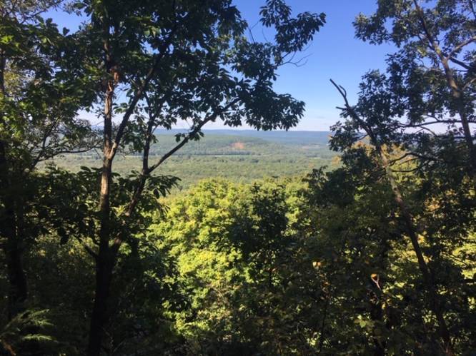
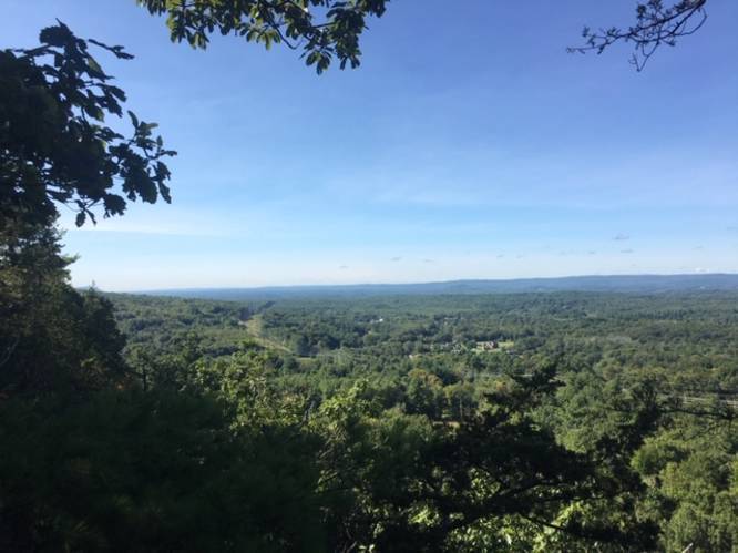
Vista Point
To reach the vista, hikers must plan on a 3-mile out-and-back hike. Please refer to the map to find the lookouts.

Parking
Hikers can find parking at the coordinates provided. The lot is large enough to fit a couple dozen cars.

Pets
Dogs are allowed if leashed and their waste must be carried out by the hiker. Off-leash areas are available, including a spot by the pond where dogs are permitted to swim.

Amenities
Pond, playground, and pavilion.
Explore 169 trails near Suffield, CT
  1. Parking

    41.99434, -72.725122
  2. Main Trailhead

    41.994419, -72.725473
  3. Small view

    41.992717, -72.734756
    Small view
  4. Vista

    41.988364, -72.735603
    Vista
No community routes found. To add your own hike as a Community Route for this Trail guide, leave a Trip Report with an attached GPX file.

Hazards

Ticks - Lyme Disease More Info (CDC)

Seasons

All

Blaze Color

Green

Photo Albums

Trip Reports

Trail Guide By:
emilyzac user profile picture
3.0 miles / 4.8 km

Weather Forecast

In Suffield, CT

Explore Hiking Trails

You May Also Like

Colorado's Million Dollar Highway - Plan a day's drive adventure along the iconic Million Dollar Highway in Colorado. Explore the best short trails, roadside stops, waterfalls, vistas, ghost towns, and hot springs within a ~6 hour road trip.
Explore

Colorado's Million Dollar Highway

Plan a day's drive adventure along the iconic Million Dollar Highway in Colorado. Explore the best short trails, roadside stops, waterfalls, vistas, ghost towns, and hot springs within a ~6 hour road trip.

Read
Glacier's Going-to-the-Sun Road - Discover the breathtaking beauty of Glacier National Park along the iconic Going-to-the-Sun Road. From stunning roadside stops to picturesque waterfalls and vistas, this engineering marvel offers endless opportunities for exploration.
Explore

Glacier's Going-to-the-Sun Road

Discover the breathtaking beauty of Glacier National Park along the iconic Going-to-the-Sun Road. From stunning roadside stops to picturesque waterfalls and vistas, this engineering marvel offers endless opportunities for exploration.

Read
New York's Best Waterfalls - Whether you're planning a day hike, roadside stop, or a leisurely short walk, this guide provides hikers, travelers, and locals alike with 63 different locations to over 100 scenic waterfalls to help plan your next adventure!
Explore

New York's Best Waterfalls

Whether you're planning a day hike, roadside stop, or a leisurely short walk, this guide provides hikers, travelers, and locals alike with 63 different locations to over 100 scenic waterfalls to help plan your next adventure!

Read

Before you boogie...

Find our trail guides useful? Consider becoming a Supporter to unlock perks!

MyHikes is an indie platform that makes exploring public trails easier for everyone. The platform has no investors, no ads, and is owned and operated by one person, Dave Miller. Dave has personally mapped and written over 1,800 trail guides on MyHikes for the public to explore. MyHikes has helped millions outdoor enthusiasts plan their next adventure.

But it takes a lot of time ๐Ÿ•ฆ, money ๐Ÿ’ฐ, work, and espresso shots โ˜• to run MyHikes, including hiking , mapping , writing , and publishing new trails with high-quality (accurate) information... along with software engineering (coding) the platform like building new features, website and mobile app development (iOS and Android), site maintainance . and much much more.

Supporters unlock website and mobile app perks with an annual one-time payment of $25 (you renew) ๐Ÿ˜Ž๐Ÿ‘. Or you can simply make a Donation of your choice. Otherwise, you can support us by telling your friends about MyHikes - both quick and free ๐ŸŽ‰

Admin user profile picture

Dave Miller
MyHikes Founder