Loading...

๐ŸŽ† 50% off 4th of July sale on Supporter Accounts โ€” now through July 6! Learn More.

Deadwood Gulch Cascades

Directions
Map
Pictures
Send to App
Distance:
0.1 Miles / 0.2 km
Type:
Out-and-Back
Difficulty:
Easy
Time to Hike:
~5 minutes
Features:
Surface Type:
Dirt
Park:
San Juan National Forest
Town:
Silverton, Colorado
Directions:
37.785058, -107.673039
Added:
June 03, 2024
Updated:
August 01, 2024
Copy Trail Link Hiking this trail? Send a friend or family member a link to this trail guide for your own safety. Hike at your own risk (disclaimer)
Loading...
Loading...
5'

Total Change
5'

Ascent
5'

Descent

Download the Trail Route for Offline Use

Supporters get exclusive access to download trail routes to the MyHikes app for offline use. Stay prepared on your adventure, even without an internet connection! Become a Supporter today to unlock this feature and hike with confidence.

Send to App

Deadwood Gulch Cascades

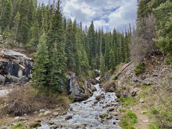
The Deadwood Gulch Cascades at San Juan National Forest near Silverton, Colorado is an easy 0.1-mile out-and-back walk that features small but scenic waterfalls within Deadwood Gulch, located along the Million Dollar Highway.

This is not a hike but rather a short roadside stop to take-in the views of the scenic Deadwood Gulch Cascades. The waterfalls can best be seen from the edge of the creek, which technically can be viewed from the parking area as well - hence this roadside stop is universally accessible and great for anyone looking for a short stop along the Million Dollar Highway. Deadwood Gulch is surrounded by evergreens that tower over the creek's rushing white water that runs down the mountain. During Spring, the freezing creek water makes for quite the scenic stop as the gulch is full to the brim with snow melt running down the mountain.

After enjoying the cascades, the short walk leads back to your car -- and onward to more stops along the Million Dollar Highway.

Parking
Visitors will find a small parking turnout located at the coordinates provided. The turnout is large enough to fit a half-dozen vehicles as of June 2024.

Pets
Dogs are allowed if leashed and should be cleaned up after.
Explore 19 trails near Silverton, CO
  1. Parking

    37.785058, -107.673039
  2. Main Trailhead

    37.785058, -107.673039
  3. Deadwood Gulch Cascades

    37.784772, -107.673128
    Deadwood Gulch Cascades
No community routes found. To add your own hike as a Community Route for this Trail guide, leave a Trip Report with an attached GPX file.

Seasons

All

Photo Albums

Trip Reports

Trail Guide By:
Admin user profile picture
0.1 miles / 0.2 km
0.1 miles / 0.2 km
June 03, 2024
Hiking

Weather Forecast

In Silverton, CO

Explore Hiking Trails

You May Also Like

Colorado's Million Dollar Highway - Plan a day's drive adventure along the iconic Million Dollar Highway in Colorado. Explore the best short trails, roadside stops, waterfalls, vistas, ghost towns, and hot springs within a ~6 hour road trip.
Explore

Colorado's Million Dollar Highway

Plan a day's drive adventure along the iconic Million Dollar Highway in Colorado. Explore the best short trails, roadside stops, waterfalls, vistas, ghost towns, and hot springs within a ~6 hour road trip.

Read
Glacier's Going-to-the-Sun Road - Discover the breathtaking beauty of Glacier National Park along the iconic Going-to-the-Sun Road. From stunning roadside stops to picturesque waterfalls and vistas, this engineering marvel offers endless opportunities for exploration.
Explore

Glacier's Going-to-the-Sun Road

Discover the breathtaking beauty of Glacier National Park along the iconic Going-to-the-Sun Road. From stunning roadside stops to picturesque waterfalls and vistas, this engineering marvel offers endless opportunities for exploration.

Read
New York's Best Waterfalls - Whether you're planning a day hike, roadside stop, or a leisurely short walk, this guide provides hikers, travelers, and locals alike with 63 different locations to over 100 scenic waterfalls to help plan your next adventure!
Explore

New York's Best Waterfalls

Whether you're planning a day hike, roadside stop, or a leisurely short walk, this guide provides hikers, travelers, and locals alike with 63 different locations to over 100 scenic waterfalls to help plan your next adventure!

Read

Before you boogie...

Find our trail guides useful? Consider becoming a Supporter to unlock perks!

MyHikes is an indie platform that makes exploring public trails easier for everyone. The platform has no investors, no ads, and is owned and operated by one person, Dave Miller. Dave has personally mapped and written over 1,800 trail guides on MyHikes for the public to explore. MyHikes has helped millions outdoor enthusiasts plan their next adventure.

But it takes a lot of time ๐Ÿ•ฆ, money ๐Ÿ’ฐ, work, and espresso shots โ˜• to run MyHikes, including hiking , mapping , writing , and publishing new trails with high-quality (accurate) information... along with software engineering (coding) the platform like building new features, website and mobile app development (iOS and Android), site maintainance . and much much more.

Supporters unlock website and mobile app perks with an annual one-time payment of $25 (you renew) ๐Ÿ˜Ž๐Ÿ‘. Or you can simply make a Donation of your choice. Otherwise, you can support us by telling your friends about MyHikes - both quick and free ๐ŸŽ‰

Admin user profile picture

Dave Miller
MyHikes Founder