The Damsite Trail at Yellow Creek State Park in Cherryhill Township, Pennsylvania is an easy-to-moderate 4.7 mile loop hike out to a lookout point above the Yellow Creek Lake dam waterfall.
The recording for this trail data starts off along the moderate half of the trail - which takes about 2.5 miles to reach the damsite. If you want an easier hike, plan to hike this route in the opposite direction by first heading north towards Yellow Creek Lake and then following the Damsite Trail along the shoreline of the lake until you reach the damsite - follow signs labeled 'damsite'.
Starting at the main trailhead for the Damsite Trail, this hike will lead you up and down hills, passing through various ravines cut out by several creeks. Follow the trail sign arrows labeled "Damsite Trail"; however, in the northern section of the trail, closer to the actual damsite, the sign labels get confusing. If you follow the signs, you'll end up hiking to the far northwest corner, then you'll hike south for about 0.5 miles before the trail cuts north again to head back toward the damsite. I believe the park cut off the shortcut trail in the northern section that heads directly to the damsite due to the very steep grade of the hill.
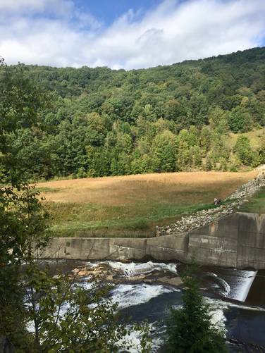
After the trail eventually turns back north, the trail will reach the damsite as you'll hike down a fairly steep grade for only 30 feet or so. From the damsite you can hike further downhill - as shown in the GPS track, but it only leads to the banks of the Yellow Creek with no view of the dam or waterfall.
Heading back is easy and mostly flat - just take the northernmost shoreline trail, which looks like an overgrown service road, back to parking. Follow signs for 'trailhead' to make your way back.
Dogs and biking are both allowed on this trail.
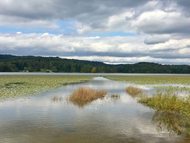
Views: Aside from the damsite, there are plenty of views of Yellow Creek Lake along the shoreline portion of the trail. If you want a quick walk out to a nice view point without a real hike, you can walk to the end of Hoffman Rd where it ends at the lake.
The recording for this trail data starts off along the moderate half of the trail - which takes about 2.5 miles to reach the damsite. If you want an easier hike, plan to hike this route in the opposite direction by first heading north towards Yellow Creek Lake and then following the Damsite Trail along the shoreline of the lake until you reach the damsite - follow signs labeled 'damsite'.
Starting at the main trailhead for the Damsite Trail, this hike will lead you up and down hills, passing through various ravines cut out by several creeks. Follow the trail sign arrows labeled "Damsite Trail"; however, in the northern section of the trail, closer to the actual damsite, the sign labels get confusing. If you follow the signs, you'll end up hiking to the far northwest corner, then you'll hike south for about 0.5 miles before the trail cuts north again to head back toward the damsite. I believe the park cut off the shortcut trail in the northern section that heads directly to the damsite due to the very steep grade of the hill.
After the trail eventually turns back north, the trail will reach the damsite as you'll hike down a fairly steep grade for only 30 feet or so. From the damsite you can hike further downhill - as shown in the GPS track, but it only leads to the banks of the Yellow Creek with no view of the dam or waterfall.
Heading back is easy and mostly flat - just take the northernmost shoreline trail, which looks like an overgrown service road, back to parking. Follow signs for 'trailhead' to make your way back.
Dogs and biking are both allowed on this trail.
Views: Aside from the damsite, there are plenty of views of Yellow Creek Lake along the shoreline portion of the trail. If you want a quick walk out to a nice view point without a real hike, you can walk to the end of Hoffman Rd where it ends at the lake.