Loading...

Distance:
2.5 Miles / 4.0 km
Type:
Loop
Difficulty:
Moderate
Time to Hike:
1 hour, ~15 minutes
Features:
Surface Type:
Dirt
Park:
Cuyahoga Valley National Park
Town:
Peninsula, Ohio
Directions:
41.223433, -81.510155
Added:
May 27, 2017
Updated:
November 19, 2018
Loading...
Loading...
119 '

Total Change
217 '

Ascent
315 '

Descent

The Ledges Trail at Cuyahoga Valley National Park is a 2.5 mile loop hike that brings you along massive rock bluffs (ledges), up to an amazing lookout point, and over to Ice Box Cave.

The loop itself is about 2 miles long, but you'll need to hike in along connector trails for a total of about 0.5 extra miles - hence, 2.5 miles total. Alternatively, you can shorten the hike by heading south from parking and hitting the trail near the lookout point first.

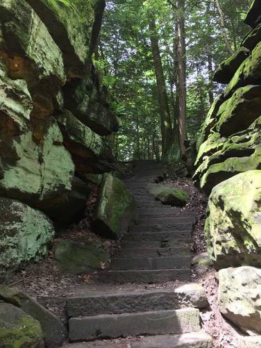
This is a must-see loop hike at Cuyahoga Valley National Park as the trail brings you along numerous impressive rock ledges. Dogs are allowed here, but biking is not. This is a very popular trail in the park as well, so prepare for a crowd near Ice Box Cave as well as the southern lookout point.

Parking: To get to the parking lot for the trailhead, drive to the coordinates provided and turn onto the street at with the sign labeled "Ledges". Follow that road all the way to the end to a large parking lot.

Explore 8 trails near Peninsula, OH
  1. Parking

    41.223433, -81.510155
  2. Main Trailhead

    41.223552, -81.510263
  3. Ledges overlook

    41.220365, -81.512125
    Ledges overlook
  4. Point-of-Interest

    41.22833, -81.510163
    Point-of-Interest
No community routes found. To add your own hike as a Community Route for this Trail guide, leave a Trip Report with an attached GPX file.

Seasons

All

Photo Albums

4 Trip Reports

No Star-Ratings
Write-up by:
Admin user profile picture
2.5 miles / 4.0 km
Trail added
May 27, 2017
Hiked on
May 27, 2017
Updated on
November 19, 2018
2.5 miles / 4.0 km
June 16, 2018
Hiking
2.5 miles / 4.0 km
March 09, 2018
Hiking
2.5 miles / 4.0 km
May 28, 2017
Hiking

Weather Forecast

In Peninsula, OH

Explore Hiking Trails

New Hikes

Cottonwood Falls Loop
1.2 Miles
1.9 km
Moderate
Loop
Sugar Hill Fire Tower Hike
0.7 Miles
1.1 km
Easy
Out-and-Back
Congaree Boardwalk Loop
2.5 Miles
4 km
Easy
Loop
Spencer Pond Loop
0.3 Miles
0.5 km
Easy
Loop

Before you leave...

MyHikes is an indie web platform aimed to make exploring public trails easier for everyone. The site has no investors and is owned and operated by one person, Dave Miller (Founder & Admin). As the Founder, main contributor, and doer-of-all-things for MyHikes, I share my trips with over-detailed write-ups for fun on a volunteer basis and I believe that public trail information should be available to everyone.

It takes a lot of time 🕦, money 💰, and effort (including espresso shots ☕) to run MyHikes, including hiking , mapping , writing , and publishing new trails with high-quality content... along with building new features, moderating, site maintainance, and app development for iOS and Android . I simply ask that if you find MyHikes' trail guides helpful to please consider becoming a Supporter to help keep the site, iOS, and Android apps available to everyone.

Supporters unlock website and in-app perks with a one-time payment of $25 (you renew) 😎👍. Or you can simply make a Donation of your choice without a MyHikes user account. Otherwise, telling your friends about MyHikes is the next-best thing - both quick and free 🎉

Thanks for visiting MyHikes and have a great hike!️

Admin user profile picture

Dave Miller
MyHikes Founder & Admin