Loading...

WINTER SALE! 50% OFF Supporter Accounts — now through January 31st. Learn More.

Crystal Lake (Hayden Trailhead)

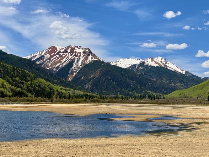
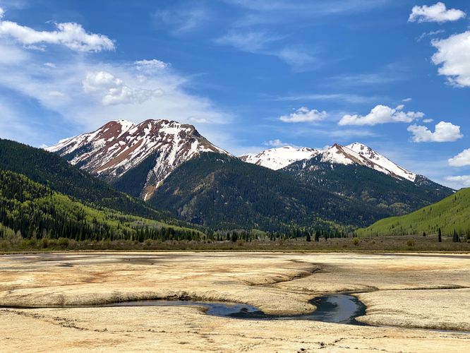
Crystal Lake (Hayden Trailhead) at Uncompahgre National Forest near Ouray, Colorado is an easy 0.3-mile out-and-back hike that features stunning views of Crystal Lake and the Red Mountains.

Hike
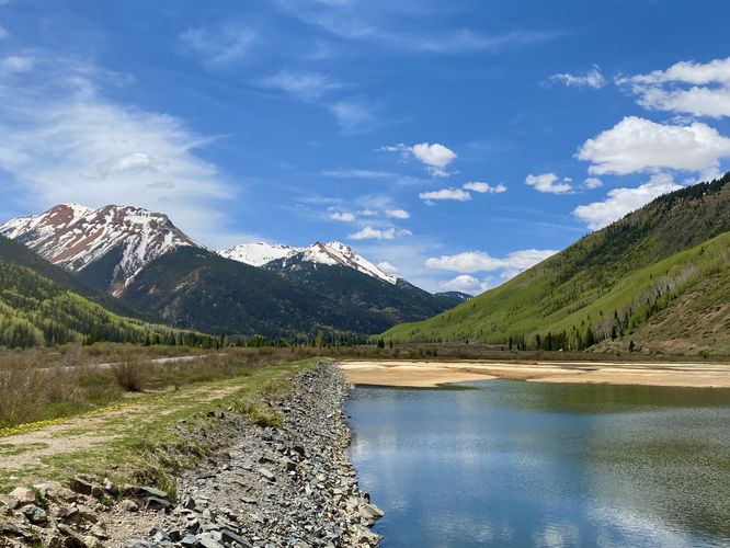
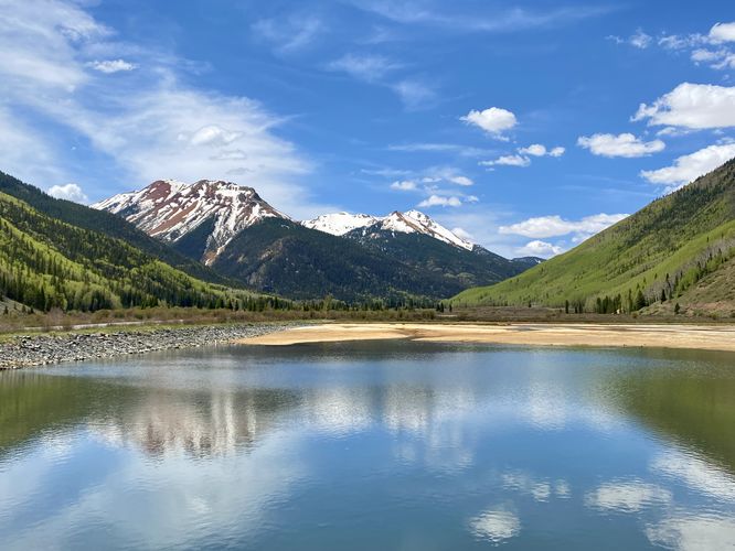
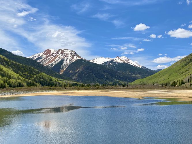
This short walk begins at the main parking lot for the Hayden Trailhead at Crystal Lake and follows the trail toward a trail junction located on the far northwest corner of the lake. The trail follows human-made dams, which appear to be built for water treatment of the acid mine runoff that flows from the mine-filled mountains to the south. Crystal Lake is one of the only (if not the only) clear and blue-body of water along the Million Dollar Highway due to the acid mine runoff that's prevalent in the creeks and streams here. This short route follows the main path as it leads around Crystal Lake featuring views for virtually the entire length of the walk. To the south are the Red Mountains (Brown Mountain, Red Mountain #1, Red Mountain #2, and Red Mountain #3) that sit in the distance above Crystal Lake. The route the leads to the banks of Crystal Lake where the creek flows in toward the main body of water -- here you can find mudflats that stretch out toward the creek as it snakes its way through the tall grass as it cuts through the landscape. After exploring Crystal Lake, the path leads out for a short 0.3-mile hike.

Parking
Hikers will find a large parking turnout at the coordinates provided, located on the west side of the Million Dollar Highway.

Pets
Dogs are allowed only if leashed and must be cleaned up after.
Explore 18 trails near Ouray, CO

Know Before You Go

  • Crystal Lake (Hayden Trailhead) is a short, easy 0.3-mile hike in Ouray, Colorado, offering beautiful views of Crystal Lake and the Red Mountains.
  • The lake's unique clear, blue color is due to acid mine runoff, and the trail passes by human-made dams used for water treatment.
  • Parking is readily available at the Hayden Trailhead, and leashed dogs are welcome but must be cleaned up after.
Interactive topographic map for Crystal Lake (Hayden Trailhead) located in Ouray, CO. Click the "View Map" button to load GPS coordinates and trail markers.
Get directions
Distance
0.3 mi
Difficulty
Easy
Type
Out-and-Back
Est. Time
9 min
Elev. Gain
27'
Rating
5.0
Added
June 03, 2024
Updated
August 01, 2024

Weather Forecast

M.L. King Jr. Day
High 34°F
Sunny
Tonight
Low 12°F
Mostly Clear
Tuesday
High 39°F
Sunny
Tuesday Night
Low 17°F
Mostly Clear
Wednesday
High 40°F
Sunny
Wednesday Night
Low 20°F
Partly Cloudy
Thursday
High 42°F
Partly Sunny
Thursday Night
Low 24°F
Chance Snow Showers
Friday
High 37°F
Snow Showers Likely
Friday Night
Low 21°F
Chance Snow Showers
Saturday
High 35°F
Chance Snow Showers
Saturday Night
Low 16°F
Slight Chance Snow Showers
Sunday
High 36°F
Slight Chance Snow Showers
Sunday Night
Low 17°F
Mostly Clear
Loading...
Total Change
24'
Ascent
27'
Descent
27'
Loading...

Download the GPX Data for Offline Use

Supporters get exclusive access to download trail routes to the MyHikes app for offline use. Stay prepared on your adventure, even without an internet connection! Become a Supporter today to unlock this feature and hike with confidence.

Download Crystal Lake (Hayden Trailhead) GPX Data to the MyHikes Mobile App

Features

Vista / Lookout Point
Dogs

Points of interest

  1. Parking

    37.959398, -107.662166
  2. Main Trailhead

    37.959466, -107.662196
  3. View of Crystal Lake by the dam

    37.959622, -107.662589
    View of Crystal Lake by the dam
  4. Mountain view, north toward Ouray

    37.959758, -107.662881
    Mountain view, north toward Ouray

Safety information

For your own safety: plan ahead, let someone know where you'll be, and hike at your own risk.

Availability

All seasons

Surface type

Dirt

Trip Reports (Reviews)

Rated 5.0 out of 5 based on 1 rating.

Ready to help fellow hikers? Add a trip report to share your experience and provide valuable insights for other hikers!

0.3 miles / 0.5 km
June 03, 2024
Short walk but the scenery was stunning. One of the only bodies of blue water in the valley along Million Dollar Highway
Hiking
No community routes found. To add your own hike as a Community Route for this Trail guide, leave a Trip Report with an attached GPX file.

Popular categories

Scenic mountain view representing vista trails
Vista trails
Scenic gorge of cascades representing waterfall trails
Waterfall hikes
Rugged mountain terrain representing summit trails
Summit trails
Scenic mountain view representing dog-friendly trails
Dog-friendly
Scenic campsite with a view representing camping trails
Camping trails
Appalachian Trail logo representing A.T. hikes
A.T. hikes

You May Also Like

Colorado's Million Dollar Highway - Plan a day's drive adventure along the iconic Million Dollar Highway in Colorado. Explore the best short trails, roadside stops, waterfalls, vistas, ghost towns, and hot springs within a ~6 hour road trip.
Explore

Colorado's Million Dollar Highway

Plan a day's drive adventure along the iconic Million Dollar Highway in Colorado. Explore the best short trails, roadside stops, waterfalls, vistas, ghost towns, and hot springs within a ~6 hour road trip.

Read
Glacier's Going-to-the-Sun Road - Discover the breathtaking beauty of Glacier National Park along the iconic Going-to-the-Sun Road. From stunning roadside stops to picturesque waterfalls and vistas, this engineering marvel offers endless opportunities for exploration.
Explore

Glacier's Going-to-the-Sun Road

Discover the breathtaking beauty of Glacier National Park along the iconic Going-to-the-Sun Road. From stunning roadside stops to picturesque waterfalls and vistas, this engineering marvel offers endless opportunities for exploration.

Read
🍪 We use cookies to learn about site usage and to serve map tiles. You may block cookies manually in the browser. By continuing you agree. Learn more