The Crowes Pasture Trail to East Beach at Crowes Pasture Conservation Area in Dennis, Massachusetts is an easy 0.9-mile out-and-back hike that features views of Quivett Neck Creek, dunes, Cape Cod Bay, and leads to East Beach.
Hike Description
This hike begins at a gated trailhead located just beyond the fork in the entrance road from where visitors can keep-right to head toward East Beach. The parking lot is located just a couple-hundred feet from that fork in the road. There's a trailhead sign with park information adjacent to the main trail. As of late March, 2023, this pasture was burned out in a controlled burn to likely help certain species of grasses, trees, and shrubs to grow - but appears like a wasteland as you hike alongside the charred remains of plants. Upon this hike on March 31, 2023, a stump was still smoldering. Regardless, the main trail heads southeast initially before curving north. Stay left along the trail to head to East Beach.
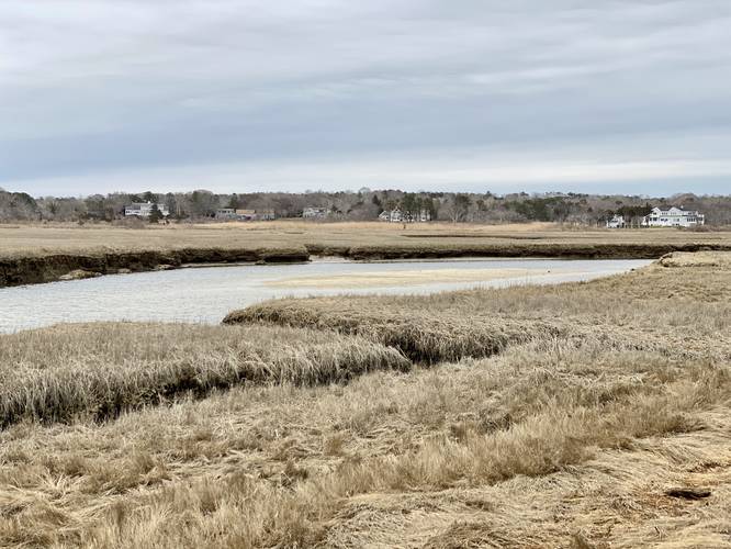
Quivett Neck Creek View - Mile 0.15
Around mile 0.15 is a small off-shoot path that leads down to a view of the Quivett Neck Creek. This is a nice spot to take a quick break and to take in the scenery on the way out to East Beach.
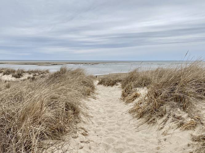
The trail will eventually reach a small parking lot around mile 0.4 where the trail heads east and into the dune area. Once at the dunes, take a left-hand turn to hike through a dune trail. This dune trail will reach East Beach around mile 0.5 where hikes can continue walking if they wish or turn back here. Before heading back, take in the views of Cape Cod Bay, East Beach, and the surrounding dunes with their wind-swept grasses.
Parking
Hikers will find a large parking lot at the coordinates provided along the entrance road to Crowes Pasture Conservation Area. Note that the road is full of large potholes as of March 2023. Drive slow.
Pets
Dogs are allowed if leashed and must be cleaned up after.
Biking
Biking appears to be allowed on this trail as the park rules do not say biking is prohibited. Please double-check to follow all rules and regulations.
Hike Description
This hike begins at a gated trailhead located just beyond the fork in the entrance road from where visitors can keep-right to head toward East Beach. The parking lot is located just a couple-hundred feet from that fork in the road. There's a trailhead sign with park information adjacent to the main trail. As of late March, 2023, this pasture was burned out in a controlled burn to likely help certain species of grasses, trees, and shrubs to grow - but appears like a wasteland as you hike alongside the charred remains of plants. Upon this hike on March 31, 2023, a stump was still smoldering. Regardless, the main trail heads southeast initially before curving north. Stay left along the trail to head to East Beach.
Quivett Neck Creek View - Mile 0.15
Around mile 0.15 is a small off-shoot path that leads down to a view of the Quivett Neck Creek. This is a nice spot to take a quick break and to take in the scenery on the way out to East Beach.
The trail will eventually reach a small parking lot around mile 0.4 where the trail heads east and into the dune area. Once at the dunes, take a left-hand turn to hike through a dune trail. This dune trail will reach East Beach around mile 0.5 where hikes can continue walking if they wish or turn back here. Before heading back, take in the views of Cape Cod Bay, East Beach, and the surrounding dunes with their wind-swept grasses.
Parking
Hikers will find a large parking lot at the coordinates provided along the entrance road to Crowes Pasture Conservation Area. Note that the road is full of large potholes as of March 2023. Drive slow.
Pets
Dogs are allowed if leashed and must be cleaned up after.
Biking
Biking appears to be allowed on this trail as the park rules do not say biking is prohibited. Please double-check to follow all rules and regulations.