Loading...

🎉 Enjoy a Free 7-Day Supporter Trial and Unlock Exclusive Perks — No Credit Card Required. Learn more.

Cranny Crow and Big Ridge Hike

Directions
Map
Pictures
Send to App
Distance:
10.8 Miles / 17.4 km
Type:
Out-and-Back
Difficulty:
Moderate
Time to Hike:
5 hours, ~24 minutes
Features:
Surface Type:
Dirt
Town:
Mathias, West Virginia
Directions:
38.892929, -78.909713
Added:
March 20, 2025
Updated:
April 06, 2025
Copy Trail Link Hiking this trail? Send a friend or family member a link to this trail guide for your own safety. Hike at your own risk (disclaimer)
Loading...
Loading...
1,266'

Total Change
2,132'

Ascent
2,125'

Descent

Download the Trail Route for Offline Use

Supporters get exclusive access to download trail routes to the MyHikes app for offline use. Stay prepared on your adventure, even without an internet connection! Become a Supporter today to unlock this feature and hike with confidence.

Send to App

Cranny Crow and Big Ridge Hike

West Virginia, renowned for its state park system, has another hidden gem in the Lost River State Park. The Cranny Crow/Big Ridge hike is a combination of a loop and out/back. With Cranny Crow, Cheeks Rock, and the Big Ridge vistas, as well as the ridge meadow, this hike has beautiful scenery around every corner in its trail system.

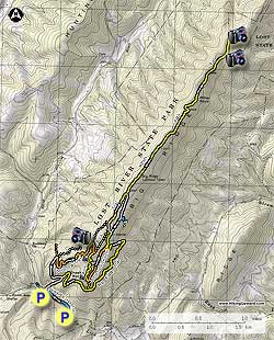
Note: As of October 2008 the blazes on several of the trails have become faded.

From the lower parking area at the Howard's Lick trailhead, cross the small suspension bridge and follow the blue blazed Howard's Lick trail 0.3 miles to the intersection of the state park service road and footbridge to the upper parking area. Turn right up the unblazed service road for 0.2 miles to the intersection of the Big Ridge Trail. Continue following the service road as it makes a sharp left continuing for another 0.5 miles to the intersection of the orange blazed White Oak Trail.

Turn right on the White Oak Trail as it continues to climb Big Ridge, then in 0.3 miles passes a small shelter and overlook. From here, the White Oak Trail will make several switchbacks before ending at the junction of the Millers Rock Trail and ridge. Turn right on the yellow blazed Millers Rock Trail, and arrive at Cranny Crow overlook in 200 yards.

Continue down the Millers Rock Trail, and pass several more overlooks of Lost River State Park, including Cheeks Rocks, before reaching the intersection of the orange blazed Virginia View Trail in another 0.3 miles.

Turn left on the Virginia View Trail for 0.6 miles to the junction of the yellow blazed Big Ridge Trail. Turn left uphill for 0.1 miles to the high meadow, large shelter, and intersection of the service road. Stay left on the service road and just after exiting the meadow pass the yellow blazed Millers Rock Trail that leads back down to the Cranny Crow Overlook. Continue downhill on the service road, and in 75 yards turn right on the continuation of the yellow blazed Millers Rock Trail.

From this point, the Millers Rock Trail will continue north along the ridge before rejoining the service road in 0.4 miles. Continue north on the service road and pass the old Big Ridge lookout tower, and caretakers cabin in 0.4 miles. From this point the Millers Rock Trail begins to descend along the ridge for 2.2 miles to first main vista to the east and south. Follow the trail another 0.1 miles to the main Big Ridge overlook.

Retrace the route back on the Millers Rock Trail past the lookout tower to the intersection where the Millers Rock Trail splits right, and the service road descends to the left. Follow the unblazed service road for 0.3 miles where the trail will pass a blue blazed trail leading to a spring. Just after passing the spring trail, the service road will enter the meadow and pass an old homestead. Continue through the meadow then start back down the yellow blazed Big Ridge Trail you ascended earlier.

In 0.1 miles pass the Virginia View Trail. Continue downhill on the Big Ridge Trail as it initially heads north, then makes a switchback back to the south. The Big Ridge Trail will continue for 1.7 miles where it ends at the service road you ascended earlier. Head down the service road for 0.2 miles to the upper parking area, then turn left back down the blue blazed Howard's Lick Trail to the lower parking area.

Explore 83 trails near Mathias, WV
  1. Parking

    38.892929, -78.909713
  2. Main Trailhead

    38.892603, -78.909302
No community routes found. To add your own hike as a Community Route for this Trail guide, leave a Trip Report with an attached GPX file.

Hazards

Ticks - Lyme Disease More Info (CDC)
Snakes
Poison Ivy/Oak

Seasons

All

Trip Reports

Trail Guide By:
HikingUpward user profile picture
10.8 miles / 17.4 km

Weather Forecast

In Mathias, WV

Explore Hiking Trails

You May Also Like

Colorado's Million Dollar Highway - Plan a day's drive adventure along the iconic Million Dollar Highway in Colorado. Explore the best short trails, roadside stops, waterfalls, vistas, ghost towns, and hot springs within a ~6 hour road trip.
Explore

Colorado's Million Dollar Highway

Plan a day's drive adventure along the iconic Million Dollar Highway in Colorado. Explore the best short trails, roadside stops, waterfalls, vistas, ghost towns, and hot springs within a ~6 hour road trip.

Read
New York's Best Waterfalls - Whether you're planning a day hike, roadside stop, or a leisurely short walk, this guide provides hikers, travelers, and locals alike with 63 different locations to over 100 scenic waterfalls to help plan your next adventure!
Explore

New York's Best Waterfalls

Whether you're planning a day hike, roadside stop, or a leisurely short walk, this guide provides hikers, travelers, and locals alike with 63 different locations to over 100 scenic waterfalls to help plan your next adventure!

Read

Before you boogie...

Find our trail guides useful? Consider becoming a Supporter to unlock perks!

MyHikes is an indie platform that makes exploring public trails easier for everyone. The platform has no investors, no ads, and is owned and operated by one person, Dave Miller. Dave has personally mapped and written over 1,800 trail guides on MyHikes for the public to explore. MyHikes has helped millions outdoor enthusiasts plan their next adventure.

But it takes a lot of time 🕦, money 💰, work, and espresso shots ☕ to run MyHikes, including hiking , mapping , writing , and publishing new trails with high-quality (accurate) information... along with software engineering (coding) the platform like building new features, website and mobile app development (iOS and Android), site maintainance . and much much more.

Supporters unlock website and mobile app perks with an annual one-time payment of $25 (you renew) 😎👍. Or you can simply make a Donation of your choice. Otherwise, you can support us by telling your friends about MyHikes - both quick and free 🎉

Admin user profile picture

Dave Miller
MyHikes Founder