Loading...

🔥 End of Summer sale! 50% off on Supporter Accounts — now through September 1st. Learn More.

Cranberry River Hike

Directions
Map
Pictures
Send to App
Distance:
17.9 Miles / 28.8 km
Type:
Loop
Difficulty:
Moderate
Time to Hike:
8 hours, ~57 minutes
Features:
Surface Type:
Dirt
Park:
Monongahela National Forest
Town:
Hillsboro, West Virginia
Directions:
38.184872, -80.280705
Added:
March 18, 2025
Updated:
April 05, 2025
Guide by:
Copy Trail Link Hiking this trail? Send a friend or family member a link to this trail guide for your own safety. Hike at your own risk (disclaimer)
Loading...
Loading...
1,415'

Total Change
2,168'

Ascent
2,163'

Descent

Download the Trail Route for Offline Use

Supporters get exclusive access to download trail routes to the MyHikes app for offline use. Stay prepared on your adventure, even without an internet connection! Become a Supporter today to unlock this feature and hike with confidence.

Send to App

Cranberry River Hike

In the Cranberry Backcountry, this 18.9 mile circuit hike traverses a ridge of old growth forest, and follows the banks of Cranberry River. Early October, when the leaves change color, is probably the prettiest time to take this backpack. The valley explodes in oranges, reds, and yellows.

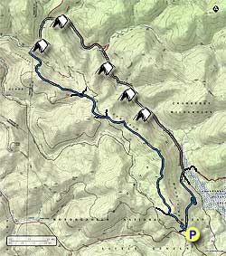
From the parking area start up the blue blazed Kennison Mountain Trail, and in 0.4 miles arrive at the intersection of the South Fork Trail. Continue straight on the Kennison Mount Trail as it climbs the ridge before reaching the junction of the Frosty Gap Trail in another 0.6 miles. Turn right, staying on the Kennison Mount Trail, and in 3.7 miles cross Forestry Road (FR) 738A.

Continue along the blue blazed Kennison Mountain Trail another 1.0 miles where the the trail crosses FR 738B. Turn right on FR 738B for 20 yards, then left uphill on the initially wider continuation of the Kennison Mount Trail. The trail will head uphill for another 0.4 miles before passing around the summit of Kennison Mountain. The Kennison trail makes a very steep descent in the last 0.5 miles before reaching Cranberry River.

Ford Cranberry River, then head 100 yards upstream to the first of many superb campsites. If this site is taken, it's only a short walk to the shelter and next camp site.

Head upstream on the non-blazed Cranberry River service road passing the Birchlog Trail, Tumbling Rock Trail and Shelter, North Fork Shelter (stay right where the North Fork Trail splits left), and South Fork Shelter where Cranberry River passes under the service road.

From this point, Cranberry River will be on the left and out of view. In another 2.1 miles, the service road arrives at the intersection of the Cow Pasture Trail on the left, and South Prong Trail on the right.

Turn right uphill on the blue blazed South Prong Trail as it climbs towards the Kennison Mountain Ridge. In 1.0 miles the trail will make a switchback to the right, then turn back to the left, and becoming steeper for the remaining 0.8 miles to the ridge, and junction of the Kennison Mountain Trail. Turn left on the Kennison Mountain Trail, and in 0.4 miles arrive back at the parking area.

Explore 19 trails near Hillsboro, WV
  1. Parking

    38.184872, -80.280705
  2. Main Trailhead

    38.185274, -80.280619
No community routes found. To add your own hike as a Community Route for this Trail guide, leave a Trip Report with an attached GPX file.

Hazards

Ticks - Lyme Disease More Info (CDC)
Snakes
Poison Ivy/Oak

Seasons

All

Blaze Color

Blue

Trip Reports (Reviews)

Rated 4.22 out of 5 based on 9 ratings.
By: Ava
17.9 miles / 28.8 km
October 09, 2019
This was my first solo backpacking trip and wow it was gorgeous. I hiked it in 2 days, following the suggestions provided, only I did day 1 in 5hrs and day 2 in 4hrs. A few things that I read in the reviews and used in my own adventure were as follows: (1) trekking poles are a must. I went after 2 days of heavy rainfall and the end of the first day was a very steep downhill. I had to go slow the last mile down to the river but it was manageable with my poles. Even if it hadn't rained I still feel poles would be very helpful. This is no easy hike, there are a lot of stretches of uphill climbs. (2) I had called the rangers station prior and was told to pack in all my water "to be safe" but man did I regret that. On the first day, yes, it is necessary to have all needed water but once you reach Cranberry river at the end of day 1, it is a great place to fill up. Also, the second half of the loop follows the river for a few miles and has many little streams you could use. (3) I didn't read this in any other review but most of the trail on day 2 is very easy. You follow the service road (which gets almost full sun FYI) and the killer hill isn't until the last 2 miles or so. Overall, this was a wonderful hike and a fun challenge, I highly recommend it!
Legacy Review
By: Joe Tinker
17.9 miles / 28.8 km
October 06, 2018
I went along with four friends to complete this hike. We elected to make this a shuttle hike, taking out the steep portion at the end by leaving a car at the gate along the river. The resulting hike was perfect. The uphill at the start of the Kennison Mountain Trail was enough to get warmed up. Most of the Kennison trail was gentle ups and downs. Trail markings were frequent, and the trail is obvious. For a ridgetop hike, there were many deep muddy spots that had to be navigated around. The last part of the Kennison Mountain Trail is a very steep, muddy downhill. The single water crossing is not difficult. Water was below the bottom of shorts, and not too fast moving. We camped at the first shelter you encounter. It is pleasant, with a great view of the stars. The road walk the following day was a nice change of pace from a tight trail. Overall I really enjoyed the hike and would highly recommend it as a wonderful 1 night trip.
Legacy Review
By: Benjamin
17.9 miles / 28.8 km
October 31, 2016
So me and my friends did this hike as a three day venture in the last weekend of October. The fall foliage was a couple of weeks past its peak, so I feel like the description is pretty accurate for the beginning of the month to be an ideal time to see fall colors. The first day we hiked from the parking area to the first campsite along the river. Water was EXTREMELY cold but all in all we had no problems crossing. The only things I would note from the first day is that when you come up to the first blue blazes that have an arrow on them pointing right, they are pointing right. We made the mistake of going straight. Also, when you come to the junction where it states to turn right up the trail, I feel like that was pretty accurate in that you have to go about 20 yards. We split the second half of the loop into two days. The walk along the service road next to the river was very easy and pleasant with PLENTY of awesome campsites along the river besides the shelters noted o the maps. The third day took us up the service road where it picks up the SOUTH FORK trial on the right. I know it says the south prong trail in the description but all three of us saw no signs with that name on it. The climb back up to the junction of the Kennison Mountain Trail was a little challenging but very manageable. All in all this was a GREAT HIKE!!!!
Legacy Review

Weather Forecast

In Hillsboro, WV

Explore Hiking Trails

You May Also Like

Colorado's Million Dollar Highway - Plan a day's drive adventure along the iconic Million Dollar Highway in Colorado. Explore the best short trails, roadside stops, waterfalls, vistas, ghost towns, and hot springs within a ~6 hour road trip.
Explore

Colorado's Million Dollar Highway

Plan a day's drive adventure along the iconic Million Dollar Highway in Colorado. Explore the best short trails, roadside stops, waterfalls, vistas, ghost towns, and hot springs within a ~6 hour road trip.

Read
New York's Best Waterfalls - Whether you're planning a day hike, roadside stop, or a leisurely short walk, this guide provides hikers, travelers, and locals alike with 63 different locations to over 100 scenic waterfalls to help plan your next adventure!
Explore

New York's Best Waterfalls

Whether you're planning a day hike, roadside stop, or a leisurely short walk, this guide provides hikers, travelers, and locals alike with 63 different locations to over 100 scenic waterfalls to help plan your next adventure!

Read

Before you boogie...

Find our trail guides useful? Consider becoming a Supporter to unlock perks!

MyHikes is an indie platform that makes exploring public trails easier for everyone. The platform has no investors, no ads, and is owned and operated by one person, Dave Miller. Dave has personally mapped and written over 1,800 trail guides on MyHikes for the public to explore. MyHikes has helped millions outdoor enthusiasts plan their next adventure.

But it takes a lot of time 🕦, money 💰, work, and espresso shots ☕ to run MyHikes, including hiking , mapping , writing , and publishing new trails with high-quality (accurate) information... along with software engineering (coding) the platform like building new features, website and mobile app development (iOS and Android), site maintainance . and much much more.

Supporters unlock website and mobile app perks with an annual one-time payment of $25 (you renew) 😎👍. Or you can simply make a Donation of your choice. Otherwise, you can support us by telling your friends about MyHikes - both quick and free 🎉

Admin user profile picture

Dave Miller
MyHikes Founder