Loading...

๐ŸŽ‰ Enjoy a Free 7-Day Supporter Trial and Unlock Exclusive Perks โ€” No Credit Card Required. Learn more.

Coyote Den Trail

Directions
Map
Pictures
Send to App
Distance:
0.7 Miles / 1.1 km
Type:
One-Way
Difficulty:
Easy
Time to Hike:
~21 minutes
Features:
Surface Type:
Dirt
Park:
Shawme-Crowell State Forest
Town:
Sandwich, Massachusetts
Directions:
41.754227, -70.514958
Added:
May 09, 2023
Updated:
May 16, 2023
Copy Trail Link Hiking this trail? Send a friend or family member a link to this trail guide for your own safety. Hike at your own risk (disclaimer)
Loading...
Loading...
62'

Total Change
38'

Ascent
87'

Descent

Download the Trail Route for Offline Use

Supporters get exclusive access to download trail routes to the MyHikes app for offline use. Stay prepared on your adventure, even without an internet connection! Become a Supporter today to unlock this feature and hike with confidence.

Send to App

Coyote Den Trail

The Coyote Den Trail at Shawme-Crowell State Forest in Sandwich, Massachusetts is an easy 0.7-mile one-way hike that features a peaceful forest setting.

Hike Description
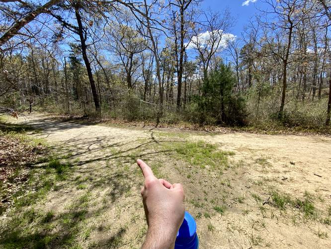
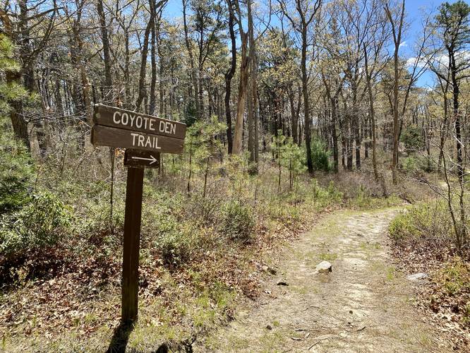
This hike begins at the parking coordinates provided within the Shawme-Crowell State Forest roads and follows a Fire Road (gated) south as it heads along a sandy trail. Hikers will reach a junction at mile 0.21 - take a right-hand turn here to reach the Coyote Den Trail trailhead just 50-feet to the east.

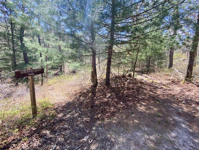
Once on the Coyote Den Trail, hikers will follow a mostly-flat sandy path as it twists and winds its way through the mixed forest full of evergreens and deciduous trees. Along the way hikers will pass the Sherri's Berry Trail, around mile 0.35 from the parking lot.

The trail will end after 0.73 miles at Pocasset Road. Hikers can hike back along the Heritage Plantation Trail.

Parking
Hikers will find a small parking turnout near the coordinates provided by the Fire Road gate. Do not block the gate. Do not park in the reserved campsite parking spots.

Pets
Dogs are allowed if leashed and must be cleaned up after.

Warning
Hunting: Hunting is allowed here year-round so it's smart to make noise or at the very least wear blaze orange so hunters can see you.

Parking & Navigating roads: The roads within Shawme-Crowell State Forest are very difficult to follow as they lack signage. Cell service is low here so it's best to use offline maps to get around the park.
Explore 45 trails near Sandwich, MA
  1. Parking

    41.754227, -70.514958
  2. Main Trailhead

    41.754227, -70.514958
  3. Left-hand turn to Coyote Den Trail

    41.751319, -70.514319
    Left-hand turn to Coyote Den Trail
  4. Coyote Den Trail trailhead

    41.751225, -70.514175
    Coyote Den Trail trailhead
  5. Sherris Berry Trail junction

    41.749767, -70.513894
    Sherris Berry Trail junction
No community routes found. To add your own hike as a Community Route for this Trail guide, leave a Trip Report with an attached GPX file.

Hazards

Ticks - Lyme Disease More Info (CDC)
Poison Ivy/Oak

Seasons

All

Blaze Color

Blue

Weather Forecast

In Sandwich, MA

Explore Hiking Trails

You May Also Like

Colorado's Million Dollar Highway - Plan a day's drive adventure along the iconic Million Dollar Highway in Colorado. Explore the best short trails, roadside stops, waterfalls, vistas, ghost towns, and hot springs within a ~6 hour road trip.
Explore

Colorado's Million Dollar Highway

Plan a day's drive adventure along the iconic Million Dollar Highway in Colorado. Explore the best short trails, roadside stops, waterfalls, vistas, ghost towns, and hot springs within a ~6 hour road trip.

Read
Glacier's Going-to-the-Sun Road - Discover the breathtaking beauty of Glacier National Park along the iconic Going-to-the-Sun Road. From stunning roadside stops to picturesque waterfalls and vistas, this engineering marvel offers endless opportunities for exploration.
Explore

Glacier's Going-to-the-Sun Road

Discover the breathtaking beauty of Glacier National Park along the iconic Going-to-the-Sun Road. From stunning roadside stops to picturesque waterfalls and vistas, this engineering marvel offers endless opportunities for exploration.

Read
New York's Best Waterfalls - Whether you're planning a day hike, roadside stop, or a leisurely short walk, this guide provides hikers, travelers, and locals alike with 63 different locations to over 100 scenic waterfalls to help plan your next adventure!
Explore

New York's Best Waterfalls

Whether you're planning a day hike, roadside stop, or a leisurely short walk, this guide provides hikers, travelers, and locals alike with 63 different locations to over 100 scenic waterfalls to help plan your next adventure!

Read

Before you boogie...

Find our trail guides useful? Consider becoming a Supporter to unlock perks!

MyHikes is an indie platform that makes exploring public trails easier for everyone. The platform has no investors, no ads, and is owned and operated by one person, Dave Miller. Dave has personally mapped and written over 1,800 trail guides on MyHikes for the public to explore. MyHikes has helped millions outdoor enthusiasts plan their next adventure.

But it takes a lot of time ๐Ÿ•ฆ, money ๐Ÿ’ฐ, work, and espresso shots โ˜• to run MyHikes, including hiking , mapping , writing , and publishing new trails with high-quality (accurate) information... along with software engineering (coding) the platform like building new features, website and mobile app development (iOS and Android), site maintainance . and much much more.

Supporters unlock website and mobile app perks with an annual one-time payment of $25 (you renew) ๐Ÿ˜Ž๐Ÿ‘. Or you can simply make a Donation of your choice. Otherwise, you can support us by telling your friends about MyHikes - both quick and free ๐ŸŽ‰

Admin user profile picture

Dave Miller
MyHikes Founder