Colyer Lake Trail
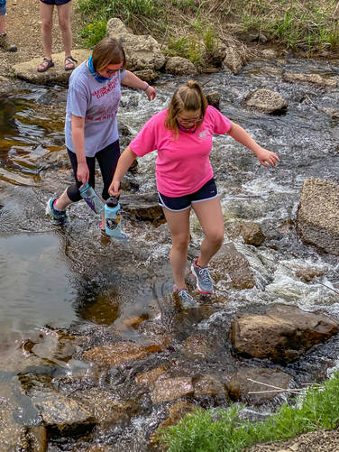
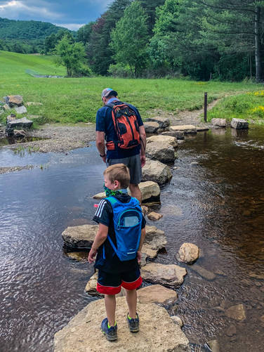
This is an easy, well maintained loop around around Colyer Lake. Perfect for a family hike. There are 3 stream crossings on the NE part of the loop. Two of them are pretty easy to navigate, the other is a little trickier during times of higher water flow.
Pets
Dogs are allowed if leashed. Note the stream crossings, so some dogs might need to be left at home especially if water levels are very high.
Biking
Biking is permitted along this trail.
Parking
Hikers will find a large parking lot at the coordinates provided.
Know Before You Go
Interactive topographic map for Colyer Lake Trail located in Centre Hall, PA. Click the "View Map" button to load GPS coordinates and trail markers.
View map
Get directions
- Distance
- 2.6 mi
- Difficulty
- Easy
- Type
- Loop
- Est. Time
- 1.3 hrs
- Elev. Gain
- 83'
- Rating
- 0.0
- Added
- March 15, 2021
- Updated
- March 15, 2021
Weather Forecast
Don't let Google decide who you trust.


Loading...
<strong>Trail map and elevation chart not rendering in print mode?</strong> Simply scroll to the trail map section, then try printing again!
Total Change
94 ft.
29 m
29 m
Ascent
83 ft.
25 m
25 m
Descent
81 ft.
25 m
25 m
Loading...
Features
- Dogs
- Biking
Points of interest
-
Parking
40.778053, -77.683887 -
Main Trailhead
40.777982, -77.683972 -
Stream crossing above dam
40.777504, -77.680361 -
Creek crossing
40.778561, -77.679908
Safety information
For your own safety: plan ahead, let someone know where you'll be, and hike at your own risk.
Availability
All seasons
Surface type
Dirt
Trip Reports (Reviews)
Ready to help fellow hikers? Add a trip report to share your experience!
No community routes found. To add your own hike as a Community Route for this Trail guide, leave a Trip Report with an attached GPX file.


You may also like

Explore
Pennsylvania's Grand Canyon
Explore Pennsylvania's Grand Canyon, officially named Pine Creek Gorge, including hiking trails, vistas, overlooks, waterfalls, backcountry campsites, backpacking trails.

Explore
New York's Best Waterfalls
Whether you're planning a day hike, roadside stop, or a leisurely short walk, this guide provides hikers, travelers, and locals alike with 63 different locations to over 100 scenic waterfalls to help plan your next adventure!

Explore
25 Best Day Hikes in West Virginia
Discover 25 of the best day hikes in West Virginia, from scenic overlooks to wilderness trails—perfect for every level of hiker.

Explore
Best of the Alps: Hiking, Adventure & Scenery
Plan your ultimate European Alps adventure! Discover the best hiking trails, epic scenery, and villages in the Swiss Alps, Dolomites, Chamonix, and Lake Como.

