Loading...

WINTER SALE! 50% OFF Supporter Accounts — now through January 31st. Learn More.

Colgate Lake Trail

The Colgate Lake Trail near East Jewett at Catskill Park is an easy 0.5-mile out-and-back walk that leads to the shores of the scenic Colgate Lake.

Walk Description
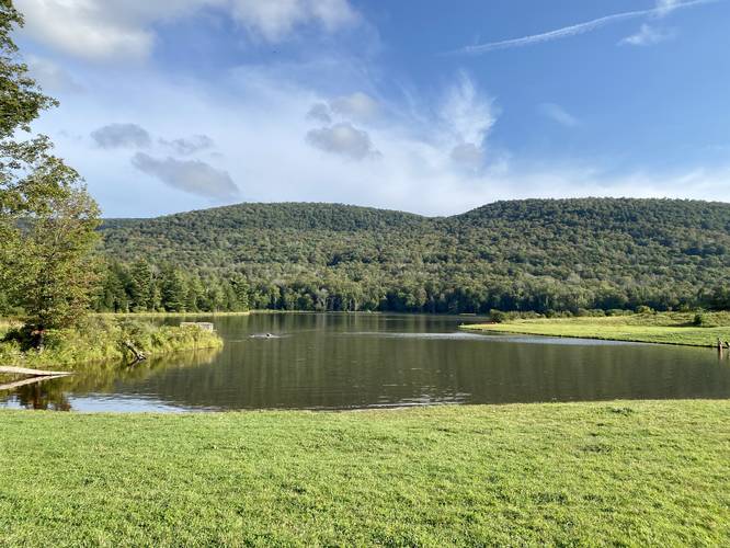
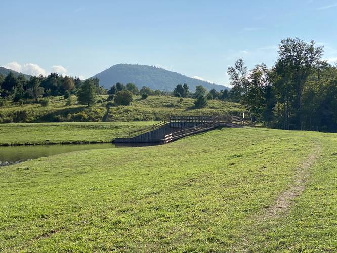
This walk begins at the main parking lot for Colgate Lake. Handicap vehicles are allowed to park right at the trailhead, but this walk begins just west of that lot and follows the road heading east to reach the handicap parking lot. At the handicap parking lot is the main trail that leads along the outer banks of Colgate Lake, crossing a footbridge that spans a spillway, and ends on the southern side of the lake. Along the way, hikers and walkers get views of Colgate Lake and the surrounding mountains.

Camping
First-come first-serve backcountry camping is permitted at Colgate Lake. Camping spots are located north of the main parking lot (coordinates provided for parking) or south of the footbridge that spans the lake's dam and spillway - located on the hill.

Parking
Hikers will find parking at the coordinates provided. The lot is large enough to fit a few dozen vehicles.

Pets
Dogs are allowed if leashed and must be cleaned up after.

Swimming
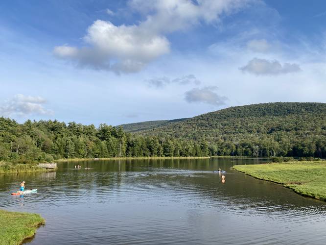
Swimming is permitted at Colgate Lake.
Explore 12 trails near East Jewett, NY

Know Before You Go

  • Colgate Lake Trail is an easy, 0.5-mile out-and-back trail in Catskill Park that leads to the shores of Colgate Lake.
  • The trail offers views of Colgate Lake and surrounding mountains, with the trailhead accessible from the main parking lot or handicap parking area.
  • Backcountry camping is permitted on a first-come, first-served basis, and swimming and leashed dogs are allowed at Colgate Lake.
Interactive topographic map for Colgate Lake Trail located in East Jewett, NY. Click the "View Map" button to load GPS coordinates and trail markers.
Get directions
Distance
0.5 mi
Difficulty
Easy
Type
Out-and-Back
Est. Time
15 min
Elev. Gain
36'
Rating
4.0
Added
September 11, 2023
Updated
September 11, 2023

Weather Forecast

Loading...
Total Change
43'
Ascent
36'
Descent
36'
Loading...

Download the GPX Data for Offline Use

Supporters get exclusive access to download trail routes to the MyHikes app for offline use. Stay prepared on your adventure, even without an internet connection! Become a Supporter today to unlock this feature and hike with confidence.

Download Colgate Lake Trail GPX Data to the MyHikes Mobile App

Features

Vista / Lookout Point
Dogs
Camping

Points of interest

  1. Parking

    42.23831, -74.12368
  2. Main Trailhead

    42.238308, -74.123603
  3. View of Colgate Lake

    42.238331, -74.121314
    View of Colgate Lake
  4. View of the Colgate Lake dam and mountains

    42.238419, -74.121117
    View of the Colgate Lake dam and mountains

Safety information

For your own safety: plan ahead, let someone know where you'll be, and hike at your own risk.

Availability

All seasons

Surface type

Dirt

Trip Reports (Reviews)

Rated 4.0 out of 5 based on 1 rating.

Ready to help fellow hikers? Add a trip report to share your experience and provide valuable insights for other hikers!

No community routes found. To add your own hike as a Community Route for this Trail guide, leave a Trip Report with an attached GPX file.

Popular categories

Scenic mountain view representing vista trails
Vista trails
Scenic gorge of cascades representing waterfall trails
Waterfall hikes
Rugged mountain terrain representing summit trails
Summit trails
Scenic mountain view representing dog-friendly trails
Dog-friendly
Scenic campsite with a view representing camping trails
Camping trails
Appalachian Trail logo representing A.T. hikes
A.T. hikes

You May Also Like

Colorado's Million Dollar Highway - Plan a day's drive adventure along the iconic Million Dollar Highway in Colorado. Explore the best short trails, roadside stops, waterfalls, vistas, ghost towns, and hot springs within a ~6 hour road trip.
Explore

Colorado's Million Dollar Highway

Plan a day's drive adventure along the iconic Million Dollar Highway in Colorado. Explore the best short trails, roadside stops, waterfalls, vistas, ghost towns, and hot springs within a ~6 hour road trip.

Read
Glacier's Going-to-the-Sun Road - Discover the breathtaking beauty of Glacier National Park along the iconic Going-to-the-Sun Road. From stunning roadside stops to picturesque waterfalls and vistas, this engineering marvel offers endless opportunities for exploration.
Explore

Glacier's Going-to-the-Sun Road

Discover the breathtaking beauty of Glacier National Park along the iconic Going-to-the-Sun Road. From stunning roadside stops to picturesque waterfalls and vistas, this engineering marvel offers endless opportunities for exploration.

Read
🍪 We use cookies to learn about site usage and to serve map tiles. You may block cookies manually in the browser. By continuing you agree. Learn more