Cold Run Waterfalls & Vista Loop at Worlds End State Park near Forksville, Pennsylvania is a moderate 3.1-mile lollipop loop hike that features a view of Loyalsock Canyon, waterfalls in Cold Run, and two rock ledge outcroppings with a boulder arch.
Trails
This hike follows two named trails and exists within both Worlds End State Park and Loyalsock State Forest. Trail names: Canyon Vista Trail (blue blazes), Cold Run Trail (yellow blazes).
Hike
This hike begins at the western-most trailhead for the Canyon Vista Trail located on PA-154 on the east side of Worlds End State Park. Hikers will have to walk up the road, heading north from the parking lot for about 300-feet to reach the trailhead. Once on the trail, the blue blazed Canyon Vista Trail ascends Loyalsock Canyon gradually along a moderate-grade trail. The terrain here can be very steep in some areas, so it's best to stay on-trail here. Along the way up the canyon, during colder months hikers will get obstructed views of Loyalsock Creek in the valley below in addition to the mountainous hillsides that line the canyon. During warmer months, these views are completely obstructed.
Cold Run Trail - Mile 0.63
Around mile 0.63, hikers will reach the trail junction with the Cold Run Trail. This is a good spot to take a short break and to catch your breath from the uphill ascent you just completed. Here, the hike becomes much more interesting as the Cold Run Trail has all of the neat scenery and points-of-interest. First up is the Cold Run Vista located down the trail.
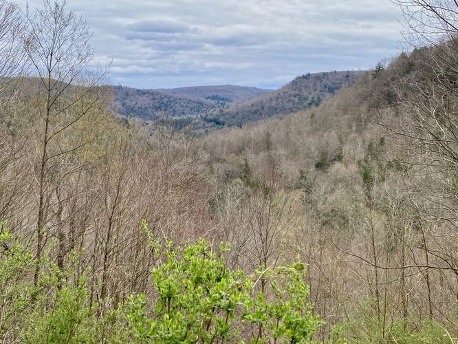
Cold Run Vista - Mile 0.87
Hikers will follow a mostly-flat but undulating path as the Cold Run Trail makes its way out and around the mountainside to reach the Cold Run Vista around mile 0.87. Cold Run Vista sits directly on-trail and as of April 2024, there was a bench with an unobstructed view of Loyalsock Canyon. Here, you can choose to sit around and take-in the views or continue onward at your own pace.
Just beyond Cold Run Vista, hikers will head down into the canyon once again to reach Cold Run creek. Along the way are interesting ledges that sit adjacent to the first switchback and make-up a good portion of the mountainside.
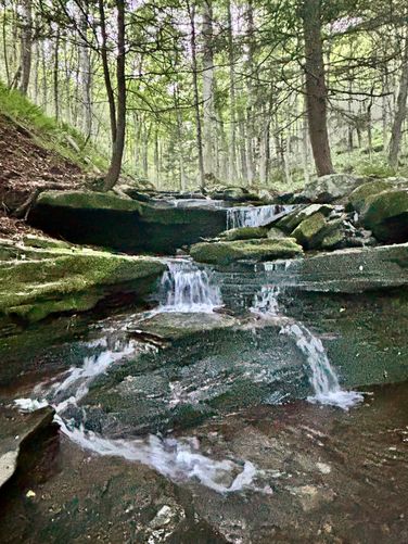
Cold Run Waterfalls - Mile 1.1 to 1.76
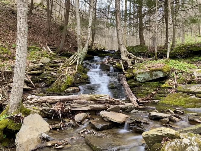
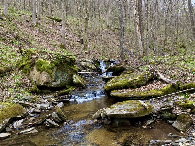
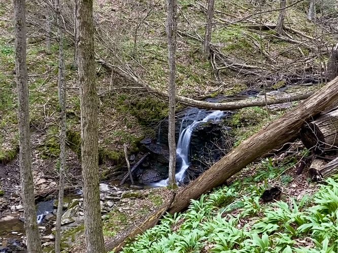
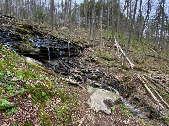
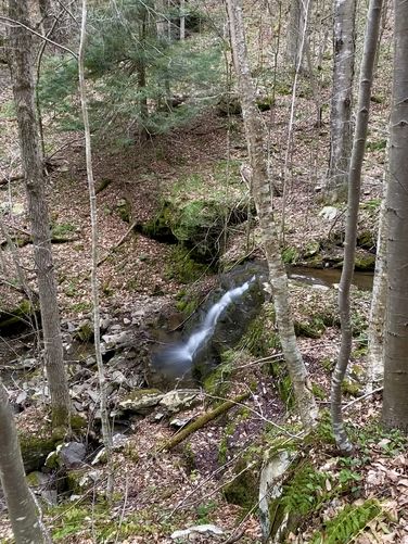
Starting around mile 1.1, located along Cold Run creek, hikers will begin to find waterfalls that cascade through this mountain hollow's bedrock. The first set of waterfalls is around mile 1.1 - this tumbling series of smaller cascades forms a ~12-foot waterfall in Cold Run. To the east lies the seasonal Gabriel Run Falls or Gabriel Falls - a ~10 to 12-foot tall free-falling waterfall. During this hike in late April 2024, Gabriel Falls was a trickle, so I did not photograph it. Further upstream, around mile 1.2 hikers will find a very short ~3-foot tall cascade that spills over bedrock within the creek - nothing super interesting, but it's something nice to look at along the hike upstream. Also note that around this mileage is where we found a hillside full of springtime red trillium wildflowers. At mile 1.3 is a ~8-foot tall waterfall that slides down the bedrock in a ravine. Just beyond, around mile 1.35 is the multi-tiered hillside waterfall known as North Branch Falls. Hikers will cross the waterfall to continue along the trail - here you can enjoy ~10-feet of cascades on either side of the trail. Watch your footing as the waterfall's bedrock can be very slippery when wet. At mile 1.4 is another ~10-foot tall waterfall that spills down Cold Run and can be best seen from the trail. One last POI that some hikers might want to head off-trail for is the base of Cold Run Falls, located around mile 1.45. To reach the base of Cold Run Falls, you must carefully hike up the creek's rocky bed to find Cold Run Falls cascading down a plethora of tiers from ~60-feet above. You really can't see a whole lot as most of the cascades are obstructed by trees, but it's a neat off-trail find if you're into that sort of thing.
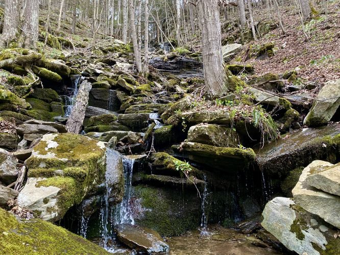
Upper Cold Run Falls - Mile 1.76
Around mile 1.76, hikers will reach the top of Cold Run Falls with its moss-covered bedrock and cliffs. The best view of the waterfall is from a precarious cliff edge (with large neighboring trees) that sits just downstream of the 2nd tier of Cold Run Falls. Due to the total height of Cold Run Falls being ~60-feet tall, you can only enjoy this waterfall in sections. This is by-far the best section to view the waterfall as the view from the base is mostly obstructed with dispersed water flow.
The hike and neat POI aren't over yet though. Continuing down the Cold Run Trail, hikers will have saved one of the best features for last - the two sections of rock ledges, boulders, and rock corridors.
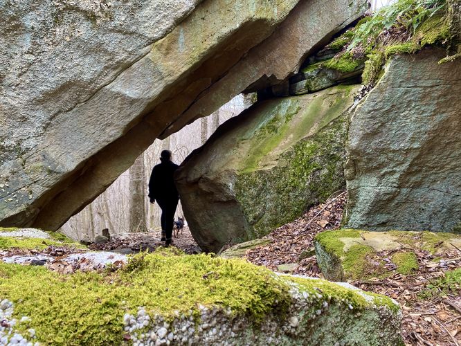
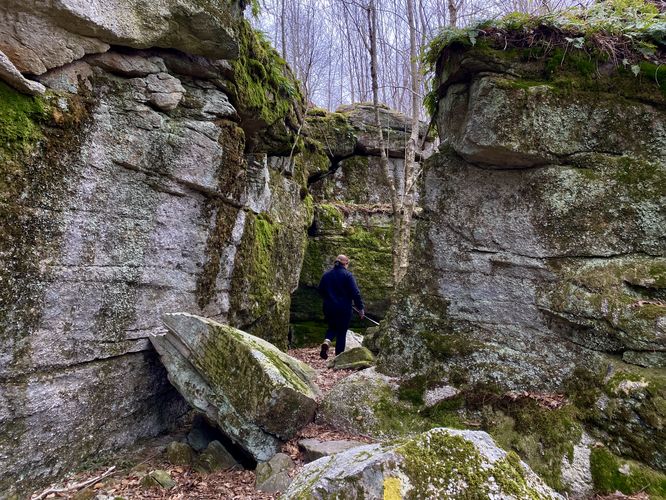
Rock Ledges & Boulder Arch - Mile 2
Around mile 2, hikers will approach the first series of rock ledges and corridors. Here, you'll step into a rock-filled world with ledges that span upwards of about 15-feet over your head on both sides. In the middle, around mile 2.1 is a neat boulder arch where the trail runs directly through it. The arch is about 6-feet tall, so most folks can just walk right through with ease.
Rock Corridor & Ledges - Mile 2.25
After passing through the first set of rock ledges and passing through the boulder arch, hikers will follow the trail through the forest to reach yet another set of rock ledges, located around mile 2.25. I nicknamed this the "rock corridor" as you pass through a stunning split in the rock ledge that feels very much like a corridor. The rock corridor bends in the middle, so you can't see through to the other side. The rock ledges are covered in moss, ferns, and lichen which add to the scenery. Just on the other side of the rock corridor, located around mile 2.3, the Cold Run Trail ends.
Canyon Vista Trail to Parking - Mile 2.3 to 3.1
Hikers will reach the end of the Cold Run Trail around mile 2.3, where you'll find blue blazes to follow back down to the trailhead. The hike back down is easy for the most part - stay left to avoid accidentally hiking the Cold Run Trail again - and stay on-trail during the super steep mountainside sections to keep safe. You'll reach the trailhead around mile 3.1 to complete this loop (lollipop) hike.
Parking
Hikers will find a large parking turnout at the coordinates provided, located along PA-154 on the east side of the park. The lot, as of April 2024, is large enough to fit a dozen vehicles.
Pets
Dogs are allowed only if leashed and must be cleaned up after.
Warnings
Steep terrain: This hike runs along very steep mountainsides, so it's best to stay on-trail. If planning to explore off-trail, be sure to do so on flatter ground. For example, a lot of the waterfalls exist within ravines that can be accessed via creek walking; however, most of the best views of the waterfalls are from the trail.
Timber Rattlesnakes: This area is home to the Timber Rattlesnake which can be found roaming the forest between the end of April and early October each year. While you're unlikely to run into any rattlers, be on the lookout and give any you find plenty of space.
Trails
This hike follows two named trails and exists within both Worlds End State Park and Loyalsock State Forest. Trail names: Canyon Vista Trail (blue blazes), Cold Run Trail (yellow blazes).
Hike
This hike begins at the western-most trailhead for the Canyon Vista Trail located on PA-154 on the east side of Worlds End State Park. Hikers will have to walk up the road, heading north from the parking lot for about 300-feet to reach the trailhead. Once on the trail, the blue blazed Canyon Vista Trail ascends Loyalsock Canyon gradually along a moderate-grade trail. The terrain here can be very steep in some areas, so it's best to stay on-trail here. Along the way up the canyon, during colder months hikers will get obstructed views of Loyalsock Creek in the valley below in addition to the mountainous hillsides that line the canyon. During warmer months, these views are completely obstructed.
Cold Run Trail - Mile 0.63
Around mile 0.63, hikers will reach the trail junction with the Cold Run Trail. This is a good spot to take a short break and to catch your breath from the uphill ascent you just completed. Here, the hike becomes much more interesting as the Cold Run Trail has all of the neat scenery and points-of-interest. First up is the Cold Run Vista located down the trail.
Cold Run Vista - Mile 0.87
Hikers will follow a mostly-flat but undulating path as the Cold Run Trail makes its way out and around the mountainside to reach the Cold Run Vista around mile 0.87. Cold Run Vista sits directly on-trail and as of April 2024, there was a bench with an unobstructed view of Loyalsock Canyon. Here, you can choose to sit around and take-in the views or continue onward at your own pace.
Just beyond Cold Run Vista, hikers will head down into the canyon once again to reach Cold Run creek. Along the way are interesting ledges that sit adjacent to the first switchback and make-up a good portion of the mountainside.
Cold Run Waterfalls - Mile 1.1 to 1.76
Starting around mile 1.1, located along Cold Run creek, hikers will begin to find waterfalls that cascade through this mountain hollow's bedrock. The first set of waterfalls is around mile 1.1 - this tumbling series of smaller cascades forms a ~12-foot waterfall in Cold Run. To the east lies the seasonal Gabriel Run Falls or Gabriel Falls - a ~10 to 12-foot tall free-falling waterfall. During this hike in late April 2024, Gabriel Falls was a trickle, so I did not photograph it. Further upstream, around mile 1.2 hikers will find a very short ~3-foot tall cascade that spills over bedrock within the creek - nothing super interesting, but it's something nice to look at along the hike upstream. Also note that around this mileage is where we found a hillside full of springtime red trillium wildflowers. At mile 1.3 is a ~8-foot tall waterfall that slides down the bedrock in a ravine. Just beyond, around mile 1.35 is the multi-tiered hillside waterfall known as North Branch Falls. Hikers will cross the waterfall to continue along the trail - here you can enjoy ~10-feet of cascades on either side of the trail. Watch your footing as the waterfall's bedrock can be very slippery when wet. At mile 1.4 is another ~10-foot tall waterfall that spills down Cold Run and can be best seen from the trail. One last POI that some hikers might want to head off-trail for is the base of Cold Run Falls, located around mile 1.45. To reach the base of Cold Run Falls, you must carefully hike up the creek's rocky bed to find Cold Run Falls cascading down a plethora of tiers from ~60-feet above. You really can't see a whole lot as most of the cascades are obstructed by trees, but it's a neat off-trail find if you're into that sort of thing.
Upper Cold Run Falls - Mile 1.76
Around mile 1.76, hikers will reach the top of Cold Run Falls with its moss-covered bedrock and cliffs. The best view of the waterfall is from a precarious cliff edge (with large neighboring trees) that sits just downstream of the 2nd tier of Cold Run Falls. Due to the total height of Cold Run Falls being ~60-feet tall, you can only enjoy this waterfall in sections. This is by-far the best section to view the waterfall as the view from the base is mostly obstructed with dispersed water flow.
The hike and neat POI aren't over yet though. Continuing down the Cold Run Trail, hikers will have saved one of the best features for last - the two sections of rock ledges, boulders, and rock corridors.
Rock Ledges & Boulder Arch - Mile 2
Around mile 2, hikers will approach the first series of rock ledges and corridors. Here, you'll step into a rock-filled world with ledges that span upwards of about 15-feet over your head on both sides. In the middle, around mile 2.1 is a neat boulder arch where the trail runs directly through it. The arch is about 6-feet tall, so most folks can just walk right through with ease.
Rock Corridor & Ledges - Mile 2.25
After passing through the first set of rock ledges and passing through the boulder arch, hikers will follow the trail through the forest to reach yet another set of rock ledges, located around mile 2.25. I nicknamed this the "rock corridor" as you pass through a stunning split in the rock ledge that feels very much like a corridor. The rock corridor bends in the middle, so you can't see through to the other side. The rock ledges are covered in moss, ferns, and lichen which add to the scenery. Just on the other side of the rock corridor, located around mile 2.3, the Cold Run Trail ends.
Canyon Vista Trail to Parking - Mile 2.3 to 3.1
Hikers will reach the end of the Cold Run Trail around mile 2.3, where you'll find blue blazes to follow back down to the trailhead. The hike back down is easy for the most part - stay left to avoid accidentally hiking the Cold Run Trail again - and stay on-trail during the super steep mountainside sections to keep safe. You'll reach the trailhead around mile 3.1 to complete this loop (lollipop) hike.
Parking
Hikers will find a large parking turnout at the coordinates provided, located along PA-154 on the east side of the park. The lot, as of April 2024, is large enough to fit a dozen vehicles.
Pets
Dogs are allowed only if leashed and must be cleaned up after.
Warnings
Steep terrain: This hike runs along very steep mountainsides, so it's best to stay on-trail. If planning to explore off-trail, be sure to do so on flatter ground. For example, a lot of the waterfalls exist within ravines that can be accessed via creek walking; however, most of the best views of the waterfalls are from the trail.
Timber Rattlesnakes: This area is home to the Timber Rattlesnake which can be found roaming the forest between the end of April and early October each year. While you're unlikely to run into any rattlers, be on the lookout and give any you find plenty of space.