Loading...

๐ŸŽ‰ Enjoy a Free 7-Day Supporter Trial and Unlock Exclusive Perks โ€” No Credit Card Required. Learn more.

Clarendon Falls

Directions
Map
Pictures
Send to App
Distance:
0.2 Miles / 0.3 km
Type:
Loop
Difficulty:
Easy
Time to Hike:
~6 minutes
Features:
Surface Type:
Dirt
Town:
Holley, New York
Directions:
43.191839, -78.065335
Added:
September 25, 2022
Updated:
November 10, 2022
Copy Trail Link Hiking this trail? Send a friend or family member a link to this trail guide for your own safety. Hike at your own risk (disclaimer)
Loading...
Loading...
58'

Total Change
35'

Ascent
22'

Descent

Download the Trail Route for Offline Use

Supporters get exclusive access to download trail routes to the MyHikes app for offline use. Stay prepared on your adventure, even without an internet connection! Become a Supporter today to unlock this feature and hike with confidence.

Send to App

Clarendon Falls

Clarendon Falls in Holley, New York is a 25-foot waterfall that can be visited in a short 0.2-mile loop or out-and-back walk.

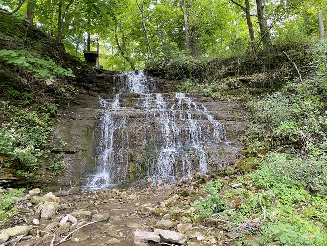
This is not a hike but rather a quick walk out to the 25-foot tall Clarendon Falls, which has two main tiers that cascade down the bedrock. Visitors can choose to simply walk to the waterfall and back to parking or walk the entire park in a short 0.2-mile loop. There's a bench that sits just below the waterfall so you can relax and enjoy the cascading water.

Private Property
Note that surrounding the park are private homes and lots. Please be respectful of the locals and stay on public land.

History - Farwell's Mills
At this site, Eldred Farwell, first white settler of the town, built the first mills in Clarendon. A saw mill was built in 1811 and a grist mill was built in 1813.

Parking
Visitors will find a small parking lot at the coordinates provided. It's large enough to fit a half-dozen vehicles as of September, 2022.

Pets
Dogs are allowed if leashed and their waste must be carried out by the hiker.
Explore 8 trails near Holley, NY
  1. Parking

    43.191839, -78.065335
  2. Main Trailhead

    43.191895, -78.065393
  3. Clarendon Falls, approx. 25-feet tall

    43.191947, -78.066161
    Clarendon Falls, approx. 25-feet tall
No community routes found. To add your own hike as a Community Route for this Trail guide, leave a Trip Report with an attached GPX file.

Hazards

Ticks - Lyme Disease More Info (CDC)
Poison Ivy/Oak

Seasons

All

Weather Forecast

In Holley, NY

Explore Hiking Trails

You May Also Like

Colorado's Million Dollar Highway - Plan a day's drive adventure along the iconic Million Dollar Highway in Colorado. Explore the best short trails, roadside stops, waterfalls, vistas, ghost towns, and hot springs within a ~6 hour road trip.
Explore

Colorado's Million Dollar Highway

Plan a day's drive adventure along the iconic Million Dollar Highway in Colorado. Explore the best short trails, roadside stops, waterfalls, vistas, ghost towns, and hot springs within a ~6 hour road trip.

Read
Glacier's Going-to-the-Sun Road - Discover the breathtaking beauty of Glacier National Park along the iconic Going-to-the-Sun Road. From stunning roadside stops to picturesque waterfalls and vistas, this engineering marvel offers endless opportunities for exploration.
Explore

Glacier's Going-to-the-Sun Road

Discover the breathtaking beauty of Glacier National Park along the iconic Going-to-the-Sun Road. From stunning roadside stops to picturesque waterfalls and vistas, this engineering marvel offers endless opportunities for exploration.

Read
New York's Best Waterfalls - Whether you're planning a day hike, roadside stop, or a leisurely short walk, this guide provides hikers, travelers, and locals alike with 63 different locations to over 100 scenic waterfalls to help plan your next adventure!
Explore

New York's Best Waterfalls

Whether you're planning a day hike, roadside stop, or a leisurely short walk, this guide provides hikers, travelers, and locals alike with 63 different locations to over 100 scenic waterfalls to help plan your next adventure!

Read

Before you boogie...

Find our trail guides useful? Consider becoming a Supporter to unlock perks!

MyHikes is an indie platform that makes exploring public trails easier for everyone. The platform has no investors, no ads, and is owned and operated by one person, Dave Miller. Dave has personally mapped and written over 1,800 trail guides on MyHikes for the public to explore. MyHikes has helped millions outdoor enthusiasts plan their next adventure.

But it takes a lot of time ๐Ÿ•ฆ, money ๐Ÿ’ฐ, work, and espresso shots โ˜• to run MyHikes, including hiking , mapping , writing , and publishing new trails with high-quality (accurate) information... along with software engineering (coding) the platform like building new features, website and mobile app development (iOS and Android), site maintainance . and much much more.

Supporters unlock website and mobile app perks with an annual one-time payment of $25 (you renew) ๐Ÿ˜Ž๐Ÿ‘. Or you can simply make a Donation of your choice. Otherwise, you can support us by telling your friends about MyHikes - both quick and free ๐ŸŽ‰

Admin user profile picture

Dave Miller
MyHikes Founder