Loading...

🍂 Prep for Fall! Unlock exclusive features to plan your perfect late-summer and autumn hikes — become a Supporter today. Learn more.

Chimney Hollow and Elliot Knob Hike

Directions
Map
Pictures
Send to App
Distance:
14.9 Miles / 24.0 km
Type:
One-Way
Difficulty:
Strenuous
Time to Hike:
7 hours, ~27 minutes
Features:
Surface Type:
Dirt
Park:
George Washington National Forest
Town:
Churchville, Virginia
Directions:
38.275044, -79.296237
Added:
January 25, 2025
Updated:
April 04, 2025
Guide by:
Copy Trail Link Hiking this trail? Send a friend or family member a link to this trail guide for your own safety. Hike at your own risk (disclaimer)
Loading...
Loading...
2,526'

Total Change
4,166'

Ascent
4,135'

Descent

Download the Trail Route for Offline Use

Supporters get exclusive access to download trail routes to the MyHikes app for offline use. Stay prepared on your adventure, even without an internet connection! Become a Supporter today to unlock this feature and hike with confidence.

Send to App

Key Takeaways

  • This is a strenuous shuttle hike (14.9 miles with significant elevation gain) near Churchville, VA, offering both challenging terrain and rewarding scenic views.
  • The hike follows a route through Chimney Hollow, up Crawford Mountain, then ascends Elliott Knob before descending via Falls Hollow.
  • An alternative, shorter shuttle hike (9.4 miles) is possible by starting at VA688.

Chimney Hollow and Elliot Knob Hike

The Chimney Hollow/Elliott Knob shuttle hike is the big brother of the Elliott Knob out and back route. At 15.4 miles and over 3,600 feet in altitude gain, this day hike is a serious workout. With great vistas, as well as nice stream walks, the hard workout is well worth the effort.

However, if that's a little more than your willing to do, you can also start at VA688 and make this a 9.4ml 2,700ft shuttle hike.

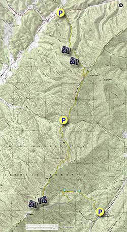
  • Mile 0.0 – From the parking area on U.S. 250 walk 50 yards to the trailhead of the yellow blazed Chimney Hollow Trail, then cross a small foot bridge built a local boy scout troop. Continue along the Chimney Hollow stream as it gradually begins to climb more steeply up the hollow then arrives at the first good viewpoint of Shenandoah Mountain. This vista spot is located just below Coalpit Knob.
  • Mile 1.7 - Continue along the Chimney Hollow Trail with the Crawford Mountain ridge visible directly ahead. At 3.2 miles the trail makes a share turn back to the left and climbs the remaining 0.2 miles to the Crawford Mountain Trail intersection and ridgeline.
  • Mile 3.3 - Turn right south along the yellow blazed Crawford Mountain Trail as the first couple of miles are a gradual decline, then the trail descends much more steeply for the next 1.6 miles down to Dry Branch Gap.
  • Mile 5.5 - Pass a closed gate at Dry Branch Gap, and cross VA688 onto the yellow blazed Elliott Knob Trail. Pass another gate as the trail starts up towards Lead-off Ridge on Great North Mountain. In 1.8 miles pass a side trail that goes down to Buffalo Spring. The spring is no longer flowing reliably. From the Buffalo Spring side trail it's a further 0.8 miles on the Elliott Knob Trail to the ridgeline.
  • Mile 8.1 - Continue to follow the Elliott Knob Trail for 1.6 miles where the trail ends at the Elliott Knob fire road.
  • Mile 9.7 - Turn right uphill on the fire road for 0.2 miles passing through a pine stand. From here the Elliott Knob Lookout Trail heads around the west side of the mountain then in 0.2 miles reach the Elliott Knob summit and fire tower. Enjoy the beautiful 270° panorama!
  • Mile 10.1 - From the summit retrace your steps back down the fire road and pass the Elliott Knob Trail you ascended earlier. Continue down the fire road another 2.0 miles at which point the yellow blazed Falls Hollow Trail enters from the left.
  • Mile 12.4 - Turn left onto the Falls Hollow Trail and follow it for 0.8 miles to the creek where the trail makes a sharp right downhill.
  • Mile 13.2 - Continue downstream on the Falls Hollow Trail passing several small waterfalls. The trail then becomes wider joining an old logging road. Continue along the logging road for another 1.0 miles where the Falls Hollow Trail ends at the parking area on VA42
  • Mile 14.9 Arrive at the VA42 and parking area.
Explore 34 trails near Churchville, VA
  1. Parking

    38.275044, -79.296237
  2. Main Trailhead

    38.27503, -79.296377
No community routes found. To add your own hike as a Community Route for this Trail guide, leave a Trip Report with an attached GPX file.

Hazards

Ticks - Lyme Disease More Info (CDC)
Snakes
Poison Ivy/Oak

Seasons

All

Blaze Color

Yellow

Photo Albums

+ Add Photo Album

Upload your photos from the trail to help others know what to expect.

Preview of the MyHikes mobile app interface

Track, Log, and Explore Hikes with the MyHikes App

Explore Autumn Foliage

No Change
Some Color
Low Color
Moderate Color
High Color
Peak Color
Past Peak
Sept 1 Sept 8 Sept 15 Sept 22 Sept 29 Oct 6 Oct 13 Oct 20 Oct 27 Nov 3 Nov 10 Nov 17 Nov 24

Trip Reports (Reviews)

Rated 4.0 out of 5 based on 2 ratings.
By: Alien Hiker
14.9 miles / 24.0 km
August 25, 2018
If this is the big brother to the Elliot knob out and back, I did the step-sister hike which is to start and end at 250. I was told to wear pants and I did, however the trail appeared to have been weeded recently. Within the first 2 miles I saw one tiny tiny tiny bear cub. It was so tiny and he/she scurried up a tree and made its way out onto a small little limb. I didn't stick around too long just cause. The rest of the hike was pretty mellow with not a lot to see. The tower was neat and so I had lunch there and scouted out the campsites. The second half of the hike was ok. It felt steep at times due to the tired legs, but it wasn't a killer. The best thing about this hike is that it was the second hike this year that I didn't have sopping wet feet from rains or flooded streams.
Legacy Review
By: Trewbie
14.9 miles / 24.0 km
May 21, 2016
A group of us hiked here this past weekend. It rained most of the time and it was a pretty brutal hike, so be in decent shape if you are planning this hike. We hiked up to Elliots Knob the first night and then back down the fire road and out to the car the next day. There was a nice flat area near the watchtower which made for a nice place to pitch tents. There is also a large area of rocks that worked well for us to cook our food (we all brought personal mini stoves). As far as water, there is a small stream once you come to fire road however after hiking all day going up that fire road and up the last little hill almost did most of us in. There is water available, but you should have a gps or something to show you where because it was right over a small mound and into the woods maybe 50 feet. (The leader of the group had his own GPS and knew where it was located.) So being plenty of water because there is nothing at the top of the hill in regards to a water source. On the trip back down it was lovely to see the water falls, and we did have to cross multiple streams so expect to wear quick drying clothes and bring extra socks as all of our shoes and socks were soaked from crossing in some parts there was no "dry" way across. Overall a nice uphill hike
Legacy Review

Weather Forecast

In Churchville, VA

Explore Hiking Trails

You May Also Like

New York's Best Waterfalls - Whether you're planning a day hike, roadside stop, or a leisurely short walk, this guide provides hikers, travelers, and locals alike with 63 different locations to over 100 scenic waterfalls to help plan your next adventure!
Explore

New York's Best Waterfalls

Whether you're planning a day hike, roadside stop, or a leisurely short walk, this guide provides hikers, travelers, and locals alike with 63 different locations to over 100 scenic waterfalls to help plan your next adventure!

Read
25 Best Day Hikes in North Carolina - Discover the top 25 best day hikes in North Carolina, from breathtaking waterfalls to mountain peaks. Explore hidden gems, scenic views, and trails suitable for all skill levels, perfect for your next outdoor adventure.
Explore

25 Best Day Hikes in North Carolina

Discover the top 25 best day hikes in North Carolina, from breathtaking waterfalls to mountain peaks. Explore hidden gems, scenic views, and trails suitable for all skill levels, perfect for your next outdoor adventure.

Read

Before you boogie...

Find our trail guides useful? Consider becoming a Supporter to unlock perks!

MyHikes is an indie platform that makes exploring public trails easier for everyone. The platform has no investors, no ads, and is owned and operated by one person, Dave Miller. Dave has personally mapped and written over 1,800 trail guides on MyHikes for the public to explore. MyHikes has helped millions outdoor enthusiasts plan their next adventure.

But it takes a lot of time 🕦, money 💰, work, and espresso shots ☕ to run MyHikes, including hiking , mapping , writing , and publishing new trails with high-quality (accurate) information... along with software engineering (coding) the platform like building new features, website and mobile app development (iOS and Android), site maintainance . and much much more.

Supporters unlock website and mobile app perks with an annual one-time payment of $25 (you renew) 😎👍. Or you can simply make a Donation of your choice. Otherwise, you can support us by telling your friends about MyHikes - both quick and free 🎉

Admin user profile picture

Dave Miller
MyHikes Founder