Loading...

🎉 Enjoy a Free 7-Day Supporter Trial and Unlock Exclusive Perks — No Credit Card Required. Learn more.

Chester Gap to Jenkins Gap Hike

Directions
Map
Pictures
Send to App
Distance:
8.2 Miles / 13.2 km
Type:
One-Way
Difficulty:
Hard
Time to Hike:
4 hours, ~6 minutes
Features:
Appalachian Trail hike
Surface Type:
Dirt
Park:
Shenandoah National Park
Town:
Warren County, Virginia
Directions:
38.877969, -78.150743
Added:
March 18, 2025
Updated:
April 05, 2025
Copy Trail Link Hiking this trail? Send a friend or family member a link to this trail guide for your own safety. Hike at your own risk (disclaimer)
Loading...
Loading...
1,974'

Total Change
2,739'

Ascent
1,340'

Descent

Download the Trail Route for Offline Use

Supporters get exclusive access to download trail routes to the MyHikes app for offline use. Stay prepared on your adventure, even without an internet connection! Become a Supporter today to unlock this feature and hike with confidence.

Send to App

Chester Gap to Jenkins Gap Hike

Chester Gap to Jenkins Gap completes the last section of the Appalachian Trail in the Northern Section of Shenandoah National Park. This is a tough climb up from Route 522, gaining about 2900' but there are some great views at Possum Rest, Compton Peak and an awesome Basalt Column Rock formation on the east overlook of Compton Peak.

We did this as a shuttle hike but with a twist, one group started from Jenkins Gap, one from Route 522, and then we traded keys when we met on the trail. If you have a big enough group (we had 8), this is a cool way to get in a point-to-point hike. Park at Compton Gap for a short version to Compton Peak and the Basalt Columns.

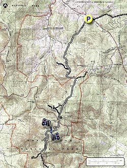
Our group of 4 did the hike from Route 522 (Chester Gap) to Jenkins Gap (MP 12.5) so that is how we will describe the hike. The White-Blazed AT heading South begins directly at the rear of the Route 522 parking area.

  • Mile 1.4 – Head south from the Parking area to Joy Spring Rd. There will be a tall metal fence for about the first mile. Just after crossing the road you will cross a small creek.
  • Mile 2.0 – Intersection to 4H Center will be on the right.
  • Mile 2.6 – Intersection to Route 601 Harmony Hollow, blue blazed trail.
  • Mile 2.9 – Spur Trail to Tom Floyd Wayside Shelter. From Route 601 to the shelter are 2 seperate trails leading to the same Spring and to a small campsite at the first sign.
  • Mile 3.6 – Possums Rest Overlook. Lots of work on this section of the trail up to the overlook, thanks PATC trail maintainers. This is a nice overlook, worth a stop just prior to entering the boundary to SNP.
  • Mile 3.8 – Intersection with Compton Gap Trail, Trail is both Yellow and White-Blazed. You can make good time on this section through to Compton Gap Parking as it is pretty level and wide.
  • Mile 5.0 – Intersection with Spring House Road on the right, yellow blazed trail bears to the right onto this.
  • Mile 5.3 – Intersection with Dickey Ridge Trail. Fort Windham Rocks are just up the trail a little ways on Dickey Ridge Trail, supposed to be nice, we did not go due to time.
  • Mile 5.5 – Compton Gap Parking - MP 10.5, cross Skyline Drive to head to Compton Peak on the AT.
  • Mile 6.4 – Compton Peak intersection, blue blazes. To the right is an overlook to the west, to the left is an overlook to the east with the Basalt Columns. These are out and back trails.
  • Mile 6.6 – West Overlook, Front Royal
  • Mile 7.0 – East Overlook and Basalt Columns, really wild rock formation. Search for “Giant's Causeway” in N. Ireland for a grander display of this same type of formation. Return to Intersection and bear left onto the AT
  • Mile 8.4 – Intersection to Jenkins Gap Parking spur trail, bear left.
  • Mile 8.5 – Jenkins Gap Parking
Explore 84 trails near Warren County, VA
  1. Parking

    38.877969, -78.150743
  2. Main Trailhead

    38.877971, -78.150687
No community routes found. To add your own hike as a Community Route for this Trail guide, leave a Trip Report with an attached GPX file.

Hazards

Ticks - Lyme Disease More Info (CDC)
Snakes
Poison Ivy/Oak

Seasons

All

Blaze Color

White

Trip Reports

Trail Guide By:
HikingUpward user profile picture
8.2 miles / 13.2 km

Weather Forecast

In Warren County, VA

Explore Hiking Trails

You May Also Like

New York's Best Waterfalls - Whether you're planning a day hike, roadside stop, or a leisurely short walk, this guide provides hikers, travelers, and locals alike with 63 different locations to over 100 scenic waterfalls to help plan your next adventure!
Explore

New York's Best Waterfalls

Whether you're planning a day hike, roadside stop, or a leisurely short walk, this guide provides hikers, travelers, and locals alike with 63 different locations to over 100 scenic waterfalls to help plan your next adventure!

Read
25 Best Day Hikes in North Carolina - Discover the top 25 best day hikes in North Carolina, from breathtaking waterfalls to mountain peaks. Explore hidden gems, scenic views, and trails suitable for all skill levels, perfect for your next outdoor adventure.
Explore

25 Best Day Hikes in North Carolina

Discover the top 25 best day hikes in North Carolina, from breathtaking waterfalls to mountain peaks. Explore hidden gems, scenic views, and trails suitable for all skill levels, perfect for your next outdoor adventure.

Read

Before you boogie...

Find our trail guides useful? Consider becoming a Supporter to unlock perks!

MyHikes is an indie platform that makes exploring public trails easier for everyone. The platform has no investors, no ads, and is owned and operated by one person, Dave Miller. Dave has personally mapped and written over 1,800 trail guides on MyHikes for the public to explore. MyHikes has helped millions outdoor enthusiasts plan their next adventure.

But it takes a lot of time 🕦, money 💰, work, and espresso shots ☕ to run MyHikes, including hiking , mapping , writing , and publishing new trails with high-quality (accurate) information... along with software engineering (coding) the platform like building new features, website and mobile app development (iOS and Android), site maintainance . and much much more.

Supporters unlock website and mobile app perks with an annual one-time payment of $25 (you renew) 😎👍. Or you can simply make a Donation of your choice. Otherwise, you can support us by telling your friends about MyHikes - both quick and free 🎉

Admin user profile picture

Dave Miller
MyHikes Founder