Loading...

Distance:
0 Miles / 0 km
Type:
Out-and-Back
Difficulty:
Easy
Time to Hike:
~5 minutes
Features:
PA Wilds
Surface Type:
Dirt
Park:
Susquehannock State Forest
Town:
Abbott, Pennsylvania
Directions:
41.645284, -77.799677
Added:
July 31, 2023
Updated:
August 24, 2023
Loading...
Loading...
1 '

Total Change
1 '

Ascent
1 '

Descent

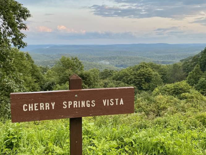
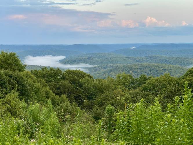
Cherry Springs Vista at Susquehannock State Forest in Abbott Township, Pennsylvania is a drive-able roadside view of the mountainous plateau of the Allegheny Mountain Range.

This is not a hike or a walk, but rather a few steps out of your car to take in the views of the mountains. This is a great spot for folks to enjoy the mountains of the PA Wilds without having to do any hiking or really any walking if they choose not to or physically can't. If you choose to walk, the distance is negligible, but there are different vantage points from each end of the parking turnout. Note that if you walk down PA-44 west just a little bit, there's a wider view of the mountains; however, watch out for highway traffic.

Parking
Visitors will find parking at the coordinates provided along PA-44. The turnout is large enough to fit just over a half-dozen vehicles.

Pets
Dogs are allowed if leashed and cleaned up after.

Explore 247 trails near Abbott, PA
  1. Parking

    41.645284, -77.799677
  2. Main Trailhead

    41.645264, -77.799607
  3. Cherry Springs Vista

    41.645208, -77.799582
    Cherry Springs Vista
  4. Cherry Springs Vista

    41.645253, -77.79995
    Cherry Springs Vista
No community routes found. To add your own hike as a Community Route for this Trail guide, leave a Trip Report with an attached GPX file.

Hazards

Ticks - Lyme Disease More Info (CDC)
Snakes
Poison Ivy/Oak

Seasons

All

Photo Albums

1 Trip Report

No Star-Ratings
Write-up by:
Admin user profile picture
0 miles / 0 km
Trail added
July 31, 2023
Hiked on
July 31, 2023
Updated on
August 24, 2023

Weather Forecast

In Abbott, PA

Explore Hiking Trails

New Hikes

Angel Falls Loop
2.8 Miles
4.5 km
Moderate
Loop
Silver Cascade
0.2 Miles
0.3 km
Easy
Out-and-Back
Bates Ferry Trail and General Greene Tree
2.7 Miles
4.3 km
Easy
Out-and-Back
Diana's Baths Trail
1.2 Miles
1.9 km
Easy
Out-and-Back

Before you leave...

MyHikes is an indie web platform aimed to make exploring public trails easier for everyone. The site has no investors and is owned and operated by one person, Dave Miller (Founder & Admin). As the Founder, main contributor, and doer-of-all-things for MyHikes, I share my trips with over-detailed write-ups for fun on a volunteer basis and I believe that public trail information should be available to everyone.

It takes a lot of time 🕦, money 💰, and effort (including espresso shots ☕) to run MyHikes, including hiking , mapping , writing , and publishing new trails with high-quality content... along with building new features, moderating, site maintainance, and app development for iOS and Android . I simply ask that if you find MyHikes' trail guides helpful to please consider becoming a Supporter to help keep the site, iOS, and Android apps available to everyone.

Supporters unlock website and in-app perks with a one-time payment of $25 (you renew) 😎👍. Or you can simply make a Donation of your choice without a MyHikes user account. Otherwise, telling your friends about MyHikes is the next-best thing - both quick and free 🎉

Thanks for visiting MyHikes and have a great hike!️

Admin user profile picture

Dave Miller
MyHikes Founder & Admin