Chapel Falls Trail
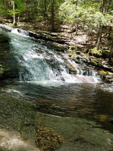
Chapel Falls is a multi-level waterfall with a few swimming spots. You can slide down the falls into some of the pools below. Hiking trails both on the bottom and top of the falls. Very popular hiking spot near Ashfield MA, but is a really cool short hike.
Know Before You Go
Interactive topographic map for Chapel Falls Trail located in Ashfield, MA. Click the "View Map" button to load GPS coordinates and trail markers.
View map
Get directions
- Distance
- 0.8 mi
- Difficulty
- Easy
- Type
- Out-and-Back
- Est. Time
- 24 min
- Elev. Gain
- 178'
- Rating
- 0.0
- Added
- July 13, 2017
- Updated
- May 30, 2019
Weather Forecast
Don't let Google decide who you trust.


Loading...
<strong>Trail map and elevation chart not rendering in print mode?</strong> Simply scroll to the trail map section, then try printing again!
Total Change
153 ft.
47 m
47 m
Ascent
178 ft.
54 m
54 m
Descent
178 ft.
54 m
54 m
Loading...
Features
- Dogs
- Waterfalls
- Water Source
- Biking
Points of interest
-
Parking
42.481988, -72.760377 -
Main Trailhead
42.481958, -72.760455
Safety information
For your own safety: plan ahead, let someone know where you'll be, and hike at your own risk.
Availability
Spring
Surface type
Dirt
No community routes found. To add your own hike as a Community Route for this Trail guide, leave a Trip Report with an attached GPX file.


You may also like

Explore
Best of the Alps: Hiking, Adventure & Scenery
Plan your ultimate European Alps adventure! Discover the best hiking trails, epic scenery, and villages in the Swiss Alps, Dolomites, Chamonix, and Lake Como.

Explore
Colorado's Million Dollar Highway
Plan a day's drive adventure along the iconic Million Dollar Highway in Colorado. Explore the best short trails, roadside stops, waterfalls, vistas, ghost towns, and hot springs within a ~6 hour road trip.

Explore
Glacier's Going-to-the-Sun Road
Discover the breathtaking beauty of Glacier National Park along the iconic Going-to-the-Sun Road. From stunning roadside stops to picturesque waterfalls and vistas, this engineering marvel offers endless opportunities for exploration.

Explore
Hike Washington's National Parks & Forests
Find the best day hikes in Washington's National Parks and Forests. Explore panoramic alpine vistas, turquoise lakes, and stunning waterfalls.
chapel brook reservation

