The Cave Spring Trail at Canyonlands National Park near Moab, Utah is an easy 0.6-mile loop hike that features a rare desert spring, an old cowboy camp, and ancient cave pictographs/markings.
Hike Description
This hike begins at the main trailhead located on the west side of the parking lot at the coordinates provided and heads-in on the Cave Spring Trail. Within the first 50-feet hikers will find a split in the loop -- since this trail has a 10-foot ladder to climb -- it's easier to hike this trail in a clockwise formation, so hence these trail notes follow that route.
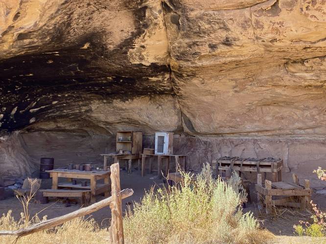
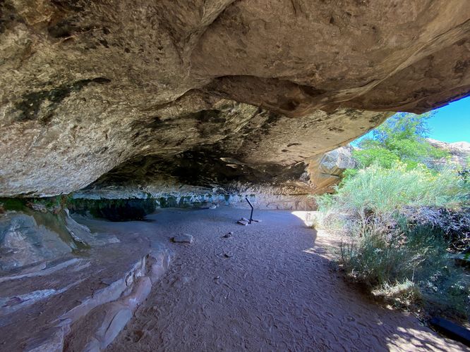
Old Cowboy Camp (1890s to 1975) - Mile 0.05
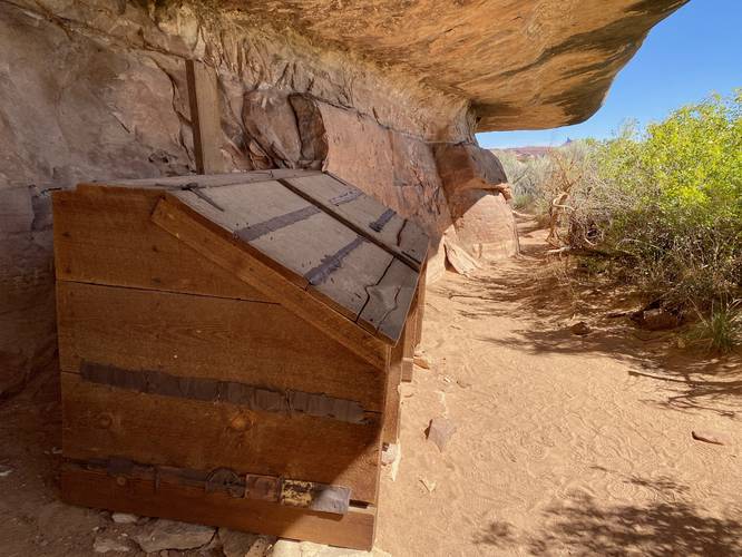
Within the first 300-feet, hikers will reach the old cowboy camp which was used by cattle ranchers from the 1890s through the 1975. This old cowboy camp alcove served as an open-air bunkhouse for cattle ranchers from the 1890s until ranching was discontinued in Canyonlands in 1975. Just around the corner, around mile 0.1, hikers will find a large wooden chest-like container which appears to be connected with the old cowboy camp, likely to store specific goods, food, or tools. Do not enter the cowboy camp as to preserve it.
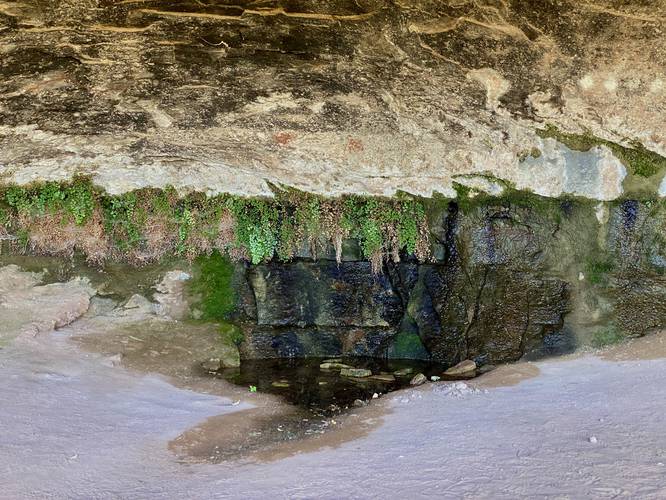
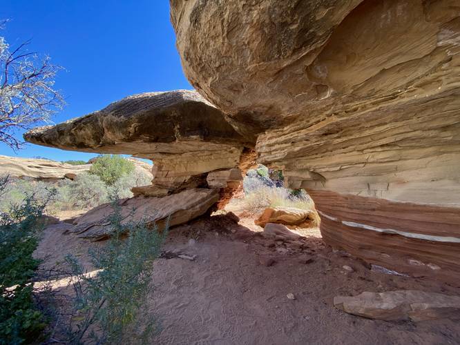
Cave Spring - Mile 0.13
Around mile 0.13, hikers will reach the massive rock overhang that houses the sacred Cave Spring. This natural spring is a rare find in a desert like Canyonland's as this is one of just a few in the area. Cave Spring is a year-round water source, which means animals and insects will travel far distances to drink its waters -- also why this water source is considered sacred. Do not drink out of or touch the spring. Upon our hike here in September 2023, we found a dozen yellow jacket hornets drinking from the spring -- clearly a sign that life depends on this water source to survive.
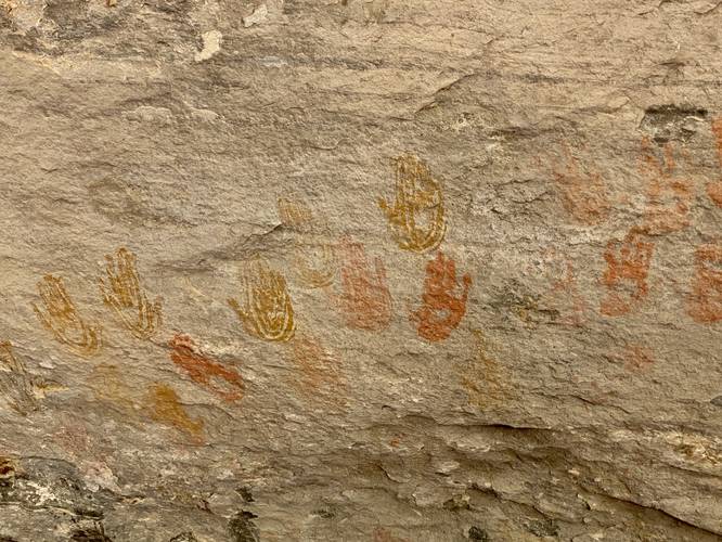
Ancient Pictographs / Markings - Mile 0.17
Around mile 0.17, hikers will find beautiful yellow, red, and orange pictographs / cave markings on the cave ceiling. These ancient markings are unique and provide more clues that the area has been used for almost 1,000 years by humans. Do not touch these markings.
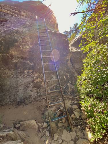
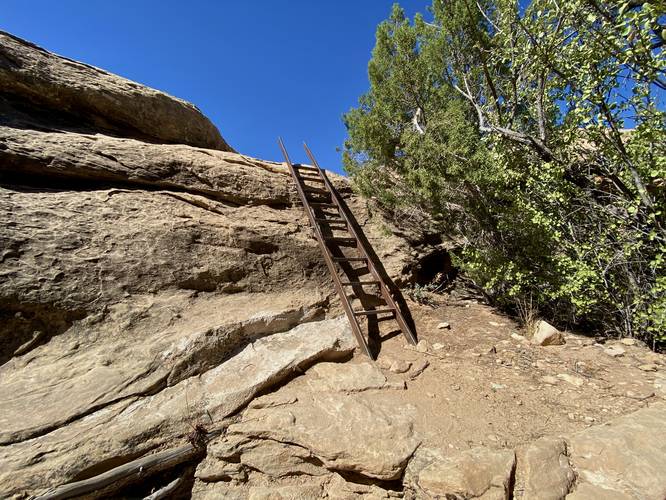
Ladder Climbs - Mile 0.2
Around mile 0.2, hikers will reach the first or two ladder climbs. The first ladder is a ~10-foot climb up a bolted-in metal ladder. The ladder is extremely sturdy and safe -- just climb to the top and head straight onto the cliff. Next, hop ~1-foot over a void to reach the continuation of the trail. Right beyond the small jump is a ~5-foot ladder that's even easier to climb.
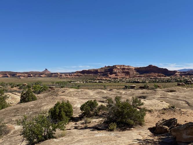
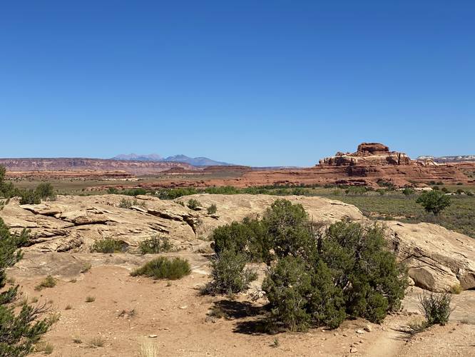
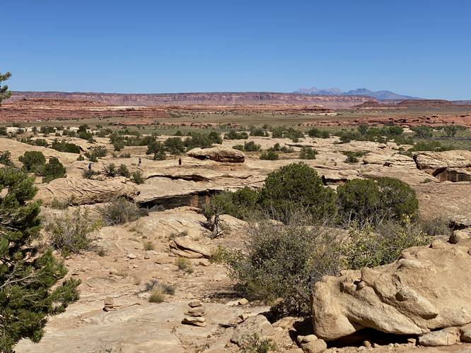
Stone Cairn Path & Views - Mile 0.2 to 0.4
After the ladder climbs, the trail follows a very-loosely defined path as it meanders around bedrock by following small stone cairns. These small stone cairns can be a bit tough to spot, so be on the lookout. Additionally, hikers will get nice views of the distant mountains and rock formations from this part of the trail.
Last Cave Overhang - Mile 0.45 to 0.6
The last noteworthy part of the hike is between mile 0.45 and 0.6 -- where hikers will pass more neat rock features including a large mushroom-shaped rock along with a very-long rock overhang that spans for a few-hundred feet. The hike will end once back at the parking lot after passing the loop junction.
Parking
Hikers will find a parking lot at the coordinates provided. The turnout is large enough to fit less than 10 cars max.
Pets
Dogs are not allowed on any trails at Canyonlands National Park. Please do not bring your dog here.
Warning
Sun exposure: This trail has very little shade and no water sources. Pack-in all water and wear sun screen and a hat to protect against sun exposure. It's smart to hike either in the early morning or late afternoon to avoid the intense desert sun.
Lack of water: Hikers must pack-in all water as there are no potable or filterable water sources along this trail. Rule of thumb in the desert is to pack-in 1 gallon of water per person per day.
Rattlesnakes: This is rattlesnake territory, so be on the lookout and give any rattlers you find plenty of space.
Fees
Vehicle entry fees to Canyonlands National Park is $30 as of September 2023.
Hike Description
This hike begins at the main trailhead located on the west side of the parking lot at the coordinates provided and heads-in on the Cave Spring Trail. Within the first 50-feet hikers will find a split in the loop -- since this trail has a 10-foot ladder to climb -- it's easier to hike this trail in a clockwise formation, so hence these trail notes follow that route.
Old Cowboy Camp (1890s to 1975) - Mile 0.05
Within the first 300-feet, hikers will reach the old cowboy camp which was used by cattle ranchers from the 1890s through the 1975. This old cowboy camp alcove served as an open-air bunkhouse for cattle ranchers from the 1890s until ranching was discontinued in Canyonlands in 1975. Just around the corner, around mile 0.1, hikers will find a large wooden chest-like container which appears to be connected with the old cowboy camp, likely to store specific goods, food, or tools. Do not enter the cowboy camp as to preserve it.
Cave Spring - Mile 0.13
Around mile 0.13, hikers will reach the massive rock overhang that houses the sacred Cave Spring. This natural spring is a rare find in a desert like Canyonland's as this is one of just a few in the area. Cave Spring is a year-round water source, which means animals and insects will travel far distances to drink its waters -- also why this water source is considered sacred. Do not drink out of or touch the spring. Upon our hike here in September 2023, we found a dozen yellow jacket hornets drinking from the spring -- clearly a sign that life depends on this water source to survive.
Ancient Pictographs / Markings - Mile 0.17
Around mile 0.17, hikers will find beautiful yellow, red, and orange pictographs / cave markings on the cave ceiling. These ancient markings are unique and provide more clues that the area has been used for almost 1,000 years by humans. Do not touch these markings.
Ladder Climbs - Mile 0.2
Around mile 0.2, hikers will reach the first or two ladder climbs. The first ladder is a ~10-foot climb up a bolted-in metal ladder. The ladder is extremely sturdy and safe -- just climb to the top and head straight onto the cliff. Next, hop ~1-foot over a void to reach the continuation of the trail. Right beyond the small jump is a ~5-foot ladder that's even easier to climb.
Stone Cairn Path & Views - Mile 0.2 to 0.4
After the ladder climbs, the trail follows a very-loosely defined path as it meanders around bedrock by following small stone cairns. These small stone cairns can be a bit tough to spot, so be on the lookout. Additionally, hikers will get nice views of the distant mountains and rock formations from this part of the trail.
Last Cave Overhang - Mile 0.45 to 0.6
The last noteworthy part of the hike is between mile 0.45 and 0.6 -- where hikers will pass more neat rock features including a large mushroom-shaped rock along with a very-long rock overhang that spans for a few-hundred feet. The hike will end once back at the parking lot after passing the loop junction.
Parking
Hikers will find a parking lot at the coordinates provided. The turnout is large enough to fit less than 10 cars max.
Pets
Dogs are not allowed on any trails at Canyonlands National Park. Please do not bring your dog here.
Warning
Sun exposure: This trail has very little shade and no water sources. Pack-in all water and wear sun screen and a hat to protect against sun exposure. It's smart to hike either in the early morning or late afternoon to avoid the intense desert sun.
Lack of water: Hikers must pack-in all water as there are no potable or filterable water sources along this trail. Rule of thumb in the desert is to pack-in 1 gallon of water per person per day.
Rattlesnakes: This is rattlesnake territory, so be on the lookout and give any rattlers you find plenty of space.
Fees
Vehicle entry fees to Canyonlands National Park is $30 as of September 2023.