The Cassidy Trail at Dixie National Forest's Red Canyon near Panguitch, Utah is an easy 1.8-mile out-and-back hike that passes through Red Canyon and features views of the surrounding rock formations and mountains.
Hike Description
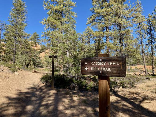
Note that this track leads hikers along a portion of the Cassidy Trail for 0.9-miles one-way before turning around -- however, the full Cassidy Trail is much longer and leads further into Red Canyon.
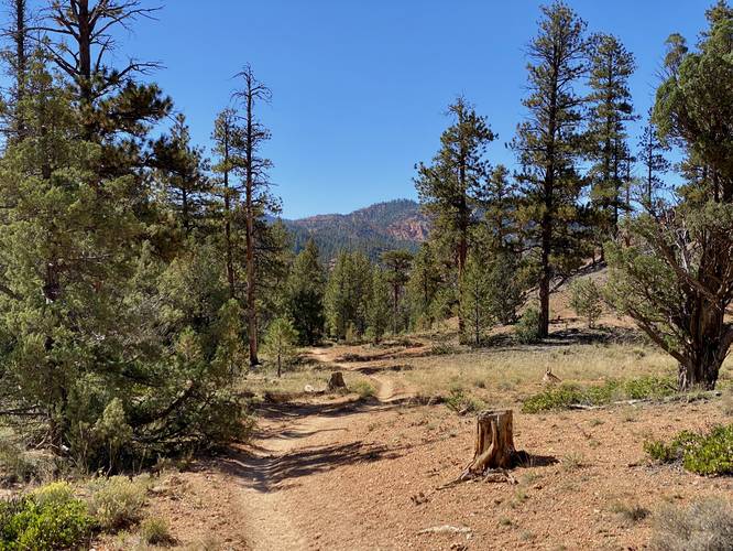
This hike begins at the Red Canyon Trailhead, which follows the Cassidy Trail that leads into Red Canyon. The trail begins by heading up a small hill before descending back down to a sandy trail that leads up a dry wash of Red Canyon. When crossing the dry wash, the trail, at times, can be a bit difficult to follow as it disappears before continuing on the other side -- often with little indication of exactly which direction it went; however, instinctively heading straight generally turns out fine and the hiker will continue along the Cassidy Trail with ease.
Along the way, hikers will find neat rock formations, especially high-up in cliffs, located pretty far off-trail. Most of these rock formations become a lot more interesting as you approach the Rich Trail, located at the 0.9-mile turn around point; however, Red Canyon is still a beautiful place to hike and explore -- especially due to the lack of people. During this hike in September 2023, we were the only hikers on the trail for the ~1 hour we were hiking.
This hike turns around at the Rich Trail, which provides neat views of the surrounding cliffs and rock formations. Here, Red Canyon appears to become even more interesting; however, we didn't have time to explore further hence the short out-and-back hike.
Views
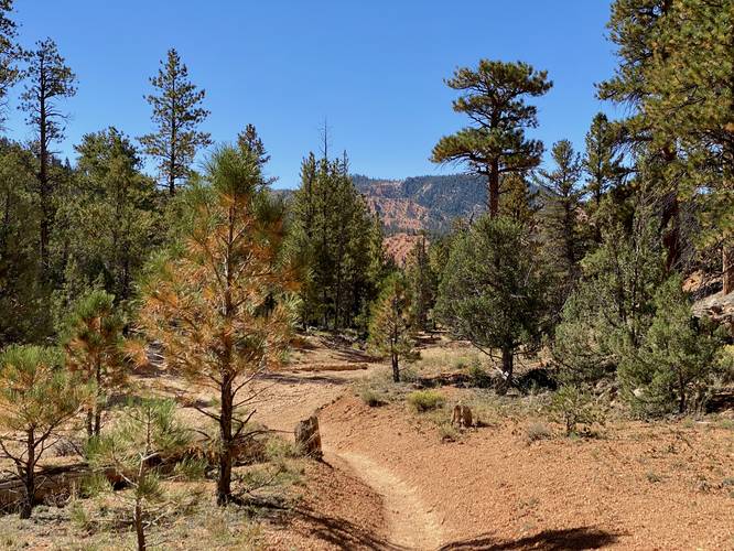
On your hike out, you'll find beautiful views of the surrounding mountains as you hike down and out of Red Canyon.
Seclusion
Red Canyon is known as "Little Bryce Canyon" and for good reason. The rock formations found in Red Canyon are the same as the ones found in Bryce Canyon. However, Red Canyon is virtually undiscovered and offers hikers spectacular views without the crowds.
Parking
Hikers will find a large parking lot at the coordinates provided along UT-12 -- this parking lot is also known as the Red Canyon Trailhead which is the main entrance to Red Canyon.
Pets
Dogs are allowed if leashed and must be cleaned up after.
Horseback Riding
This is a popular horseback riding trail.
Warnings
Rattlesnakes: This trail passes through rattlesnake territory, so be on the lookout. Give any rattlers you find plenty of space.
Mountain lions: This trail passes through canyon territory that might be good habitat for Utah's native mountain lions. It's smart to make some noise while hiking and if you can, hike with another person.
Lack of water: There are no water sources along this hike, so you must pack-in all water for yourself. It's smart to carry about 1 gallon of water per person per day of hiking.
Flash flooding: Due to the dry wash crossing, hikers should be aware of local weather upstream before hitting the trail to ensure they avoid flash flooding.
Hike Description
Note that this track leads hikers along a portion of the Cassidy Trail for 0.9-miles one-way before turning around -- however, the full Cassidy Trail is much longer and leads further into Red Canyon.
This hike begins at the Red Canyon Trailhead, which follows the Cassidy Trail that leads into Red Canyon. The trail begins by heading up a small hill before descending back down to a sandy trail that leads up a dry wash of Red Canyon. When crossing the dry wash, the trail, at times, can be a bit difficult to follow as it disappears before continuing on the other side -- often with little indication of exactly which direction it went; however, instinctively heading straight generally turns out fine and the hiker will continue along the Cassidy Trail with ease.
Along the way, hikers will find neat rock formations, especially high-up in cliffs, located pretty far off-trail. Most of these rock formations become a lot more interesting as you approach the Rich Trail, located at the 0.9-mile turn around point; however, Red Canyon is still a beautiful place to hike and explore -- especially due to the lack of people. During this hike in September 2023, we were the only hikers on the trail for the ~1 hour we were hiking.
This hike turns around at the Rich Trail, which provides neat views of the surrounding cliffs and rock formations. Here, Red Canyon appears to become even more interesting; however, we didn't have time to explore further hence the short out-and-back hike.
Views
On your hike out, you'll find beautiful views of the surrounding mountains as you hike down and out of Red Canyon.
Seclusion
Red Canyon is known as "Little Bryce Canyon" and for good reason. The rock formations found in Red Canyon are the same as the ones found in Bryce Canyon. However, Red Canyon is virtually undiscovered and offers hikers spectacular views without the crowds.
Parking
Hikers will find a large parking lot at the coordinates provided along UT-12 -- this parking lot is also known as the Red Canyon Trailhead which is the main entrance to Red Canyon.
Pets
Dogs are allowed if leashed and must be cleaned up after.
Horseback Riding
This is a popular horseback riding trail.
Warnings
Rattlesnakes: This trail passes through rattlesnake territory, so be on the lookout. Give any rattlers you find plenty of space.
Mountain lions: This trail passes through canyon territory that might be good habitat for Utah's native mountain lions. It's smart to make some noise while hiking and if you can, hike with another person.
Lack of water: There are no water sources along this hike, so you must pack-in all water for yourself. It's smart to carry about 1 gallon of water per person per day of hiking.
Flash flooding: Due to the dry wash crossing, hikers should be aware of local weather upstream before hitting the trail to ensure they avoid flash flooding.