Cascade Overlook at Adirondack Park within the Sentinel Range Wilderness in North Elba, New York is a moderate 3-mile out-and-back hike that leads to a mountainside overlook of Cascade Mountain and Upper Cascade Lake.
Trails
This hike follows the Pitchoff Mountain Trail.
Hike Description
Hikers will begin along NY-73 across the street for Cascade Mountain, located just down the hill. There's a brown trailhead sign for the Sentinel Ranger Wilderness Area and Pitchoff Mountain. Hike up the stairs / hillside here to reach a trail registry. Signing-in and signing-out here is smart just in case something were to happen on the trail.
The hike up the mountain is not very difficult but starts out at a moderate grade almost immediately from the trailhead along NY-73. Eventually, around mile 0.25, the elevation grade levels out as the trail follows the top of a somewhat-flat mountain ridge.
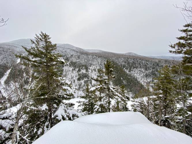
Cascade Mountain Vista - Mile 0.85
Around mile 0.85, hikers will find a rocky outcropping south of the trail that provides a decent view of Cascade Mountain with some evergreen trees in the foreground that block part of the view.
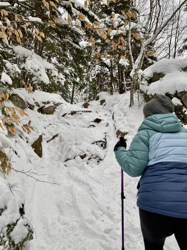
Rock Scrambles (8-feet) - Mile 0.9 & 1
Around mile 0.9, hikers will reach a ~8-foot tall rock scramble. During warmer months this scramble might not be difficult, but during the winter, with snowshoes, this scramble can be a bit tricky. Since snowshoes are not required by law in the Sentinel Range Wilderness, winter hikers can substitute ice spikes / crampons here instead. Shortly after this rock scramble is yet another short rock scramble around mile 1, but this time it's a skinnier path. In snowshoes this scramble is a bit tricky too.
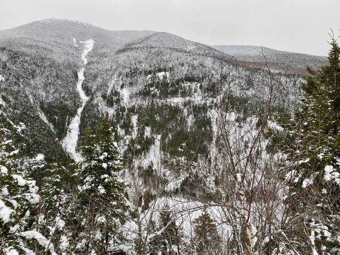
Cascade Overlook - Mile 1.05
Just after 1 mile (1.05), hikers will reach the main destination for this hike - Cascade Overlook, which provides an awesome view of Cascade Mountain and the brooks that runs down its northwest slopes. This overlook also provides views of Upper Cascade Lake. If turning back here, this hike is a 2.1-mile out-and-back hike.
Hiking Further
The original goal of this hike was to summit Pitchoff Mountain in late January; however, we decided to turn around after the saddle in the mountain in the middle of the large boulder field as the trail started ascending the mountain once more. Maybe someday we'll be back to explore the top of Pitchoff Mountain; however, hopefully Cascade Overlook (and this write-up) makes for a fun hike for folks in the future.
Parking
Hikers will find parking at the coordinates provided. The parking lots are separated into three sections with two larger parking lots. The smaller of the three lots can fit a handful of cars while the larger of the three lots can fit more than 5, but less than 10 cars. Note the parking situation because of the popularity of the Cascade Mountain hike which shares the same lots.
Pets
Dogs are allowed if leashed and their waste should be carried out by the hiker.
Blaze Color
This hike follows circular red blazes. Some are so faded that they appear a light red / orange as of late January, 2023.
Trails
This hike follows the Pitchoff Mountain Trail.
Hike Description
Hikers will begin along NY-73 across the street for Cascade Mountain, located just down the hill. There's a brown trailhead sign for the Sentinel Ranger Wilderness Area and Pitchoff Mountain. Hike up the stairs / hillside here to reach a trail registry. Signing-in and signing-out here is smart just in case something were to happen on the trail.
The hike up the mountain is not very difficult but starts out at a moderate grade almost immediately from the trailhead along NY-73. Eventually, around mile 0.25, the elevation grade levels out as the trail follows the top of a somewhat-flat mountain ridge.
Cascade Mountain Vista - Mile 0.85
Around mile 0.85, hikers will find a rocky outcropping south of the trail that provides a decent view of Cascade Mountain with some evergreen trees in the foreground that block part of the view.
Rock Scrambles (8-feet) - Mile 0.9 & 1
Around mile 0.9, hikers will reach a ~8-foot tall rock scramble. During warmer months this scramble might not be difficult, but during the winter, with snowshoes, this scramble can be a bit tricky. Since snowshoes are not required by law in the Sentinel Range Wilderness, winter hikers can substitute ice spikes / crampons here instead. Shortly after this rock scramble is yet another short rock scramble around mile 1, but this time it's a skinnier path. In snowshoes this scramble is a bit tricky too.
Cascade Overlook - Mile 1.05
Just after 1 mile (1.05), hikers will reach the main destination for this hike - Cascade Overlook, which provides an awesome view of Cascade Mountain and the brooks that runs down its northwest slopes. This overlook also provides views of Upper Cascade Lake. If turning back here, this hike is a 2.1-mile out-and-back hike.
Hiking Further
The original goal of this hike was to summit Pitchoff Mountain in late January; however, we decided to turn around after the saddle in the mountain in the middle of the large boulder field as the trail started ascending the mountain once more. Maybe someday we'll be back to explore the top of Pitchoff Mountain; however, hopefully Cascade Overlook (and this write-up) makes for a fun hike for folks in the future.
Parking
Hikers will find parking at the coordinates provided. The parking lots are separated into three sections with two larger parking lots. The smaller of the three lots can fit a handful of cars while the larger of the three lots can fit more than 5, but less than 10 cars. Note the parking situation because of the popularity of the Cascade Mountain hike which shares the same lots.
Pets
Dogs are allowed if leashed and their waste should be carried out by the hiker.
Blaze Color
This hike follows circular red blazes. Some are so faded that they appear a light red / orange as of late January, 2023.