Loading...

๐ŸŽ‰ Enjoy a Free 7-Day Supporter Trial and Unlock Exclusive Perks โ€” No Credit Card Required. Learn more.

Carp River Kiln - Iron Ore Heritage Trail

Directions
Map
Pictures
Send to App
Distance:
0.1 Miles / 0.2 km
Type:
Out-and-Back
Difficulty:
Easy
Time to Hike:
~5 minutes
Features:
Surface Type:
Dirt
Park:
Iron Ore Heritage Trail
Town:
Marquette, Michigan
Directions:
46.517991, -87.383631
Added:
September 25, 2022
Updated:
September 30, 2022
Copy Trail Link Hiking this trail? Send a friend or family member a link to this trail guide for your own safety. Hike at your own risk (disclaimer)
Loading...
Loading...
3'

Total Change
3'

Ascent
3'

Descent

Download the Trail Route for Offline Use

Supporters get exclusive access to download trail routes to the MyHikes app for offline use. Stay prepared on your adventure, even without an internet connection! Become a Supporter today to unlock this feature and hike with confidence.

Send to App

Carp River Kiln - Iron Ore Heritage Trail

The Carp River Kiln in Marquette, Michigan is and easy 0.1-mile out-and-back walk that leads to the historical iron ore kiln that was once a part of the critical iron industry that used to thrive here.

Trails
This short walk is just a tiny segment of the 42-mile Iron Ore Heritage Trail. Note that this section of the Iron Ore Heritage Trail also follows a segment of the North Country Trail here.

Walk Description
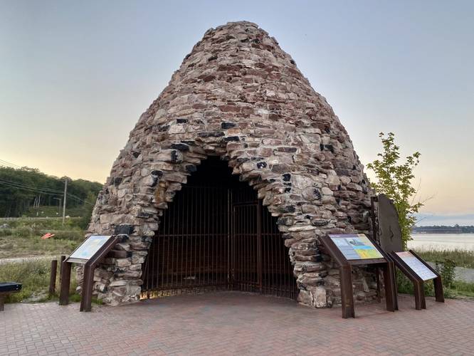
This is not a hike, but rather a short walk to a resurrected iron furnace that was used to feed the Carp River Blast Furnace which produced pig iron. The original kiln collapsed during a snow storm in 2016 and thus, the Iron Ore Heritage Trail raised funds to rebuild the furnace and to setup an interpretive site. The Carp River kiln that stands today was rebuilt using the same sandstone from other collapsed Carp River kilns.

The history of pig iron and Michigan's iron ore ties in with Pittsburgh's history as well, as much of Michigan's iron ore was processed and shipped through the Great Lakes to reach Pittsburgh for further processing. After living in Pittsburgh, PA for ~4 years, visiting by this furnace was personally really neat as it reminded me of hiking and exploring around the old iron ore furnaces, mostly located around Western Pennsylvania like the Eliza Furnace along the Ghost Town Trail.

Parking
Hikers will find parking located at the coordinates provided. The lot is large enough to fit a dozen vehicles or so.

Pets
Dogs are allowed if leashed and their waste must be carried out by the hiker.
Explore 5 trails near Marquette, MI
  1. Parking

    46.517991, -87.383631
  2. Main Trailhead

    46.518291, -87.383742
  3. View of Lake Superior from the North Country Trail / Iron Ore Heritage Trail

    46.518392, -87.383806
    View of Lake Superior from the North Country Trail / Iron Ore Heritage Trail
  4. Carp River Furnace (iron ore furnace)

    46.518842, -87.384422
    Carp River Furnace (iron ore furnace)
No community routes found. To add your own hike as a Community Route for this Trail guide, leave a Trip Report with an attached GPX file.

Hazards

Ticks - Lyme Disease More Info (CDC)

Seasons

All

Photo Albums

Trip Reports

Trail Guide By:
Admin user profile picture
0.1 miles / 0.2 km
0.1 miles / 0.2 km
September 20, 2022
Hiking

Weather Forecast

In Marquette, MI

Explore Hiking Trails

You May Also Like

Colorado's Million Dollar Highway - Plan a day's drive adventure along the iconic Million Dollar Highway in Colorado. Explore the best short trails, roadside stops, waterfalls, vistas, ghost towns, and hot springs within a ~6 hour road trip.
Explore

Colorado's Million Dollar Highway

Plan a day's drive adventure along the iconic Million Dollar Highway in Colorado. Explore the best short trails, roadside stops, waterfalls, vistas, ghost towns, and hot springs within a ~6 hour road trip.

Read
Glacier's Going-to-the-Sun Road - Discover the breathtaking beauty of Glacier National Park along the iconic Going-to-the-Sun Road. From stunning roadside stops to picturesque waterfalls and vistas, this engineering marvel offers endless opportunities for exploration.
Explore

Glacier's Going-to-the-Sun Road

Discover the breathtaking beauty of Glacier National Park along the iconic Going-to-the-Sun Road. From stunning roadside stops to picturesque waterfalls and vistas, this engineering marvel offers endless opportunities for exploration.

Read
New York's Best Waterfalls - Whether you're planning a day hike, roadside stop, or a leisurely short walk, this guide provides hikers, travelers, and locals alike with 63 different locations to over 100 scenic waterfalls to help plan your next adventure!
Explore

New York's Best Waterfalls

Whether you're planning a day hike, roadside stop, or a leisurely short walk, this guide provides hikers, travelers, and locals alike with 63 different locations to over 100 scenic waterfalls to help plan your next adventure!

Read

Before you boogie...

Find our trail guides useful? Consider becoming a Supporter to unlock perks!

MyHikes is an indie platform that makes exploring public trails easier for everyone. The platform has no investors, no ads, and is owned and operated by one person, Dave Miller. Dave has personally mapped and written over 1,800 trail guides on MyHikes for the public to explore. MyHikes has helped millions outdoor enthusiasts plan their next adventure.

But it takes a lot of time ๐Ÿ•ฆ, money ๐Ÿ’ฐ, work, and espresso shots โ˜• to run MyHikes, including hiking , mapping , writing , and publishing new trails with high-quality (accurate) information... along with software engineering (coding) the platform like building new features, website and mobile app development (iOS and Android), site maintainance . and much much more.

Supporters unlock website and mobile app perks with an annual one-time payment of $25 (you renew) ๐Ÿ˜Ž๐Ÿ‘. Or you can simply make a Donation of your choice. Otherwise, you can support us by telling your friends about MyHikes - both quick and free ๐ŸŽ‰

Admin user profile picture

Dave Miller
MyHikes Founder