Loading...

🎉 Enjoy a Free 7-Day Supporter Trial and Unlock Exclusive Perks — No Credit Card Required. Learn more.

Cape Sebastian Trail (Coast Trail)

Directions
Map
Pictures
Send to App
Distance:
2.7 Miles / 4.3 km
Type:
Out-and-Back
Difficulty:
Easy
Time to Hike:
1 hour, ~21 minutes
Features:
Surface Type:
Dirt
Park:
Cape Sebastian State Scenic Corridor
Town:
Gold Beach, Oregon
Directions:
Cape Sebastian Trail

42.328887, -124.425797
Added:
August 14, 2019
Updated:
August 22, 2019
Copy Trail Link Hiking this trail? Send a friend or family member a link to this trail guide for your own safety. Hike at your own risk (disclaimer)
Loading...
Loading...
696'

Total Change
784'

Ascent
784'

Descent

Download the Trail Route for Offline Use

Supporters get exclusive access to download trail routes to the MyHikes app for offline use. Stay prepared on your adventure, even without an internet connection! Become a Supporter today to unlock this feature and hike with confidence.

Send to App

Cape Sebastian Trail (Coast Trail)

The Cape Sebastian Trail (Coast Trail) at the Cape Sebastian State Scenic Corridor in Gold Beach, Oregon is a moderate 2.7-mile out-and-back trail that runs along a steep ridge and down to Hunters Cove and features stunning views of the Oregon coastline.

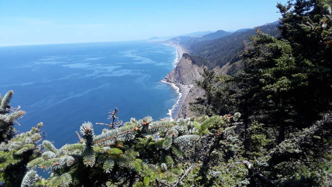
This trail begins at the main parking lot and heads southwest and then eventually due-south heading downhill towards Hunters Cove. Along the hike down, hikers will pass benches at vista points that feature breathtaking views of the Oregon coast.

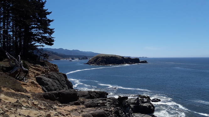
The trail winds down the hill, passing several switchbacks, before reaching Hunter Cove. Hunter Cove is yet another breathtaking beach where hikers can settle down for a picnic or just rest to take in the views before heading back uphill.

Views: The best view point along the trail can be found just 0.15-miles from the parking lot - just before the trail starts heading downhill. For people with not much time, at the very least, it's worth stopping by this lookout point.

Pets: Dogs are allowed if leashed and their waste must be carried out by the hiker.

Parking: Parking can be found at the coordinates provided in the large lot suitable for at least 20 vehicles.
Explore 21 trails near Gold Beach, OR
  1. Parking

    42.328887, -124.425797
  2. Main Trailhead

    42.328934, -124.426173
  3. Beautiful vista point - oregon coastline

    42.328611, -124.428611
    Beautiful vista point - oregon coastline
  4. Vista point

    42.319722, -124.428611
    Vista point
No community routes found. To add your own hike as a Community Route for this Trail guide, leave a Trip Report with an attached GPX file.

Hazards

Snakes
Poison Ivy/Oak
Rockfalls / Ledges / or Scrambles

Seasons

All

Photo Albums

Trip Reports

Trail Guide By:
VanDemanJr user profile picture
2.7 miles / 4.3 km

Weather Forecast

In Gold Beach, OR

Explore Hiking Trails

You May Also Like

Colorado's Million Dollar Highway - Plan a day's drive adventure along the iconic Million Dollar Highway in Colorado. Explore the best short trails, roadside stops, waterfalls, vistas, ghost towns, and hot springs within a ~6 hour road trip.
Explore

Colorado's Million Dollar Highway

Plan a day's drive adventure along the iconic Million Dollar Highway in Colorado. Explore the best short trails, roadside stops, waterfalls, vistas, ghost towns, and hot springs within a ~6 hour road trip.

Read
Glacier's Going-to-the-Sun Road - Discover the breathtaking beauty of Glacier National Park along the iconic Going-to-the-Sun Road. From stunning roadside stops to picturesque waterfalls and vistas, this engineering marvel offers endless opportunities for exploration.
Explore

Glacier's Going-to-the-Sun Road

Discover the breathtaking beauty of Glacier National Park along the iconic Going-to-the-Sun Road. From stunning roadside stops to picturesque waterfalls and vistas, this engineering marvel offers endless opportunities for exploration.

Read
New York's Best Waterfalls - Whether you're planning a day hike, roadside stop, or a leisurely short walk, this guide provides hikers, travelers, and locals alike with 63 different locations to over 100 scenic waterfalls to help plan your next adventure!
Explore

New York's Best Waterfalls

Whether you're planning a day hike, roadside stop, or a leisurely short walk, this guide provides hikers, travelers, and locals alike with 63 different locations to over 100 scenic waterfalls to help plan your next adventure!

Read

Before you boogie...

Find our trail guides useful? Consider becoming a Supporter to unlock perks!

MyHikes is an indie platform that makes exploring public trails easier for everyone. The platform has no investors, no ads, and is owned and operated by one person, Dave Miller. Dave has personally mapped and written over 1,800 trail guides on MyHikes for the public to explore. MyHikes has helped millions outdoor enthusiasts plan their next adventure.

But it takes a lot of time 🕦, money 💰, work, and espresso shots ☕ to run MyHikes, including hiking , mapping , writing , and publishing new trails with high-quality (accurate) information... along with software engineering (coding) the platform like building new features, website and mobile app development (iOS and Android), site maintainance . and much much more.

Supporters unlock website and mobile app perks with an annual one-time payment of $25 (you renew) 😎👍. Or you can simply make a Donation of your choice. Otherwise, you can support us by telling your friends about MyHikes - both quick and free 🎉

Admin user profile picture

Dave Miller
MyHikes Founder