The Canfield Island Loop in Montoursville, Pennsylvania is an easy universally-accessible 1.2-mile loop hike that features views of the West Branch Susquehanna River and passes through an archeological site.
Universal Access
This trail follows an ADA universally-accessible pathway, as of June 2020.
Hike Description
This hike begins at the main parking lot for Canfield Island Park located off of Greevey Road. There are two trails that lead into the park and each trail leads into the same place - the Canfield Island Loop. Once on the loop trail, the hiker will pass through an open field that the trail encompasses. Along the way are information kiosks that educate the walker about Canfield Islands archeological sites and the people that once occupied this land. Note that this GPS data and mileage provided follow the loop counter-clockwise.
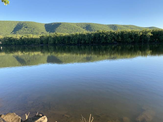
River & Mountains View - Mile 0.4
Around mile 0.4, hikers will reach the first view of the West Branch Susquehanna River with the rugged mountains in the background. This is a nice spot to take in the views for a minute before continuing.
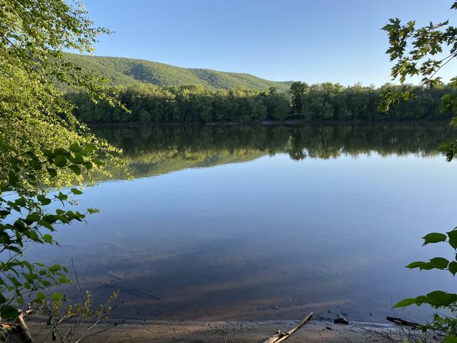
2nd River & Mountain View - Mile 0.65
Just down the trail is another view of the river and surrounding mountains, located around mile 0.65.
The loop trail will quickly reach the beginning where the walker has the choice to either end and head back to the parking lot or continue the loop for more exercise.
Parking
Hikers will find parking at the coordinates provided, located off of Greevey Road.
Pets
Dogs are allowed if leashed and should be cleaned up after.
Archeological Site
The Society for Pennsylvania Archeology has conducted numerous excavations on Canfield Island. While studying the Canfield Archeological Site, volunteers unearthed evidence of human occupation dating as far back as 4835 B.C. Ten feet of excavation unearthed evidence of at least ten different cultural groups. Spear heads and tools were used to date societies from 4835 B.C. to 1550 A.D.
Universal Access
This trail follows an ADA universally-accessible pathway, as of June 2020.
Hike Description
This hike begins at the main parking lot for Canfield Island Park located off of Greevey Road. There are two trails that lead into the park and each trail leads into the same place - the Canfield Island Loop. Once on the loop trail, the hiker will pass through an open field that the trail encompasses. Along the way are information kiosks that educate the walker about Canfield Islands archeological sites and the people that once occupied this land. Note that this GPS data and mileage provided follow the loop counter-clockwise.
River & Mountains View - Mile 0.4
Around mile 0.4, hikers will reach the first view of the West Branch Susquehanna River with the rugged mountains in the background. This is a nice spot to take in the views for a minute before continuing.
2nd River & Mountain View - Mile 0.65
Just down the trail is another view of the river and surrounding mountains, located around mile 0.65.
The loop trail will quickly reach the beginning where the walker has the choice to either end and head back to the parking lot or continue the loop for more exercise.
Parking
Hikers will find parking at the coordinates provided, located off of Greevey Road.
Pets
Dogs are allowed if leashed and should be cleaned up after.
Archeological Site
The Society for Pennsylvania Archeology has conducted numerous excavations on Canfield Island. While studying the Canfield Archeological Site, volunteers unearthed evidence of human occupation dating as far back as 4835 B.C. Ten feet of excavation unearthed evidence of at least ten different cultural groups. Spear heads and tools were used to date societies from 4835 B.C. to 1550 A.D.